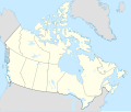
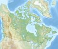
Faili halisi (faili la SVG, husemwa kuwa piseli 1,114 × 942, saizi ya faili: 365 KB)
Muhtasari Map Info
Properties
Projection:
Lambert conformal conic
Datum:
WGS84
Central Meridian:
95.000000°W
Latitude of Origin:
60.000000°N
Standard Parallel #1:
49.000000°N
Standard Parallel #2:
77.000000°N
Mathematics (conversion from latitude and longitude to image coordinate)
x (%)=
201.7818903*(((tan(pi*(90-$1)/360))*(((1+0.08181919084*sin(pi*$1/180))/(1-0.08181919084*sin(pi*$1/180)))^0.04090959542))^0.9007900864)*sin(0.01572175288*($2+95))+43.98563734
y (%)=
238.6252927*(((tan(pi*(90-$1)/360))*(((1+0.08181919084*sin(pi*$1/180))/(1-0.08181919084*sin(pi*$1/180)))^0.04090959542))^0.9007900864)*cos(0.01572175288*($2+95))-15.81495465
$1:
latitude in degrees (positive for all locations in Canada).
$2:
longitude in degrees (negative for all locations in Canada).
x (%):
x coordinate expressed as percentage of image width (measured from left edge).
y (%):
y coordinate expressed as percentage of image height (measured from top edge).
POIs
x (px)
y (px)
x (%)
y (%)
Latitude
Longitude
Top Left Corner:
0.000
0.000
0.00
0.00
68.220310°N
176.138684°W
Top Right Corner:
1114.000
0.000
100.00
0.00
62.238635°N
9.994317°W
Bottom Right Corner:
1114.000
942.000
100.00
100.00
34.831244°N
61.953430°W
Bottom Left Corner:
0.000
942.000
0.00
100.00
37.392537°N
121.850536°W
Centre:
557.000
471.000
50.00
50.00
63.068962°N
88.152750°W
Origin:
490.000
541.000
43.99
57.43
60.000000°N
95.000000°W
North Pole:
490.000
-148.977
43.99
-15.81
90.000000°N
⸻
Thechàl Dhâl:
67.523
368.241
6.06
39.09
61.022873°N
138.564925°W
Hatimiliki I, the copyright holder of this work, hereby publish it under the following license:
Uko huru:
kushiriki – kunakili na kusambaza kazi hiyokwa remix – kurekebisha kazi
Chini ya masharti yafuatayo:
sifa – Ni lazima utoe mkopo unaofaa, utoe kiungo cha leseni, na uonyeshe ikiwa mabadiliko yalifanywa. Unaweza kufanya hivyo kwa njia yoyote inayofaa, lakini si kwa njia yoyote inayopendekeza mtoa leseni akuidhinishe wewe au matumizi yako.
shiriki sawa
– Ukichanganya, kubadilisha, au kujenga juu ya nyenzo, lazima usambaze michango yako chini ya same or compatible license kama ya awali. https://creativecommons.org/licenses/by-sa/4.0 CC BY-SA 4.0 Creative Commons Attribution-Share Alike 4.0 true true Kiswahili Add a one-line explanation of what this file represents
Kifaransa carte politique du Canada
Kifaransa cha Kajuni Location map of Canada
Historia ya faili
Matumizi ya faili
Kurasa hizi 4 zimeunganishwa na faili hili:
Matumizi ya faili ulimwenguni
Wiki nyingine hutumia faili hizi:
Matumizi kwa af.wikipedia.org
Matumizi kwa azb.wikipedia.org
Matumizi kwa ban.wikipedia.org
Matumizi kwa ca.wikipedia.org
Matumizi kwa en.wikipedia.org
Tazama matumizi zaidi ya kimataifa ya faili hii.
Faili hili lina maarifa mengine, yamkini kutoka kemra au skana iliyotumiwa kulitengeneza au kuliandaa kwa tarakilishi.
Kama faili limebadilishwa kutoka hali yake ya awali, inawezekana kwamba vipengele kadhaa vitakuwa tofauti kuliko hali ya picha ilivyo sasa.


