Faili:Mohammad adil-Rashidun-empire-at-its-peak-close.PNG
Ukubwa wa hakikisho: piseli 800 × 388. Ukubwa zingine: piseli 320 × 155 | piseli 640 × 310 | piseli 1,196 × 580.
Faili halisi (piseli 1,196 × 580, saizi ya faili: 58 KB, aina ya MIME: image/png)
| Faili hili linatoka Wikimedia Commons. Maelezo yapo kule kwenye ukurasa wake wa maelezo unaonekana hapo chini.
|

|
This map image could be re-created using vector graphics as an SVG file. This has several advantages; see Commons:Media for cleanup for more information. If an SVG form of this image is available, please upload it and afterwards replace this template with
{{vector version available|new image name}}.
It is recommended to name the SVG file “Mohammad adil-Rashidun-empire-at-its-peak-close.svg”—then the template Vector version available (or Vva) does not need the new image name parameter. |
Muhtasari
| Maelezo |
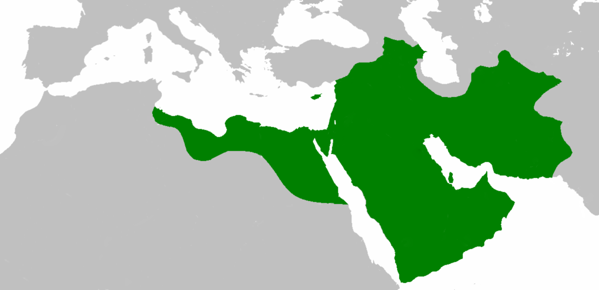
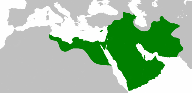
العربية: اتساع الدولة الإسلامية في عهد الخليفة عثمان بن عفان English: Empire of the Rashidun Caliphate at its peak. |
|||
| Tarehe | 21 Julai 2007 (original upload date) | |||
| Chanzo | Transferred from en.wikipedia to Commons. | |||
| Mwandishi | Mohammad adil at Kiingereza Wikipedia | |||
| Matoleo mengine |
|

Hatimiliki
Mohammad adil from en.wikipedia.org, the copyright holder of this work, hereby publishes it under the following license:
| Faili hii imeidhinishwa chini ya Creative Commons Attribution- Attribution-Share Alike 3.0 Unported leseni. Subject to disclaimers. | ||
| Sifa: Mohammad adil from en.wikipedia.org | ||
shiriki sawa – Ukichanganya, kubadilisha, au kujenga juu ya nyenzo, lazima usambaze michango yako chini ya same or compatible license kama ya awali. | ||
| This licensing tag was added to this file as part of the GFDL licensing update. |

|
Ruhusa inakubalika kunakili, kusambaza na/au kurekebisha chini ya matakwa ya GNU Free Documentation License, Toleo 1.2 au toleo lolote lile la baadaye ambalo litachapishwa na Free Software Foundation; lisilo na Sehemu Tofauti, lisilo na Maandishi-Kava-Kwa-Mbele, na lisilo na Maandishi-Kava-Kwa -Nyuma. Nakala ya hatimiliki inajumlishwa kwenye sehemu ilioitwa GNU Free Documentation License. Subject to disclaimers. |
Kumbukumbu ya upakizaji wa asili
The original description page was here. All following user names refer to en.wikipedia.
- 2010-04-25 09:06 Cplakidas 1196×580× (50435 bytes) whoops
- 2010-04-25 08:59 Cplakidas 1196×580× (50513 bytes) corrections: Crete, Rhodes, Sicily, Cilicia, W. Armenia & Iberia were raided and invaded, but not permanently occupied until much later. In Africa, the Exarchate of Carthage still controlled most of Tunisia, and no Arabs had yet reached Spain.
- 2009-05-01 06:26 Mohammad adil 1196×580× (46594 bytes) {{GFDL-self-with-disclaimers}}
- 2009-01-26 14:13 Mohammad adil 1196×580× (95308 bytes)
- 2008-03-28 21:12 Mohammad adil 1400×680× (48613 bytes) {{GFDL-self-with-disclaimers}}
- 2008-03-28 21:08 Mohammad adil 1400×680× (48472 bytes) {{GFDL-self-with-disclaimers}}
- 2007-07-21 19:15 Mohammad adil 1400×690× (47455 bytes) {{GFDL-self-with-disclaimers}}
Historia ya faili
Bonyeza tarehe/saa kuona faili kama ilivyoonekana wakati huo.
| Tarehe/Saa | Picha ndogo | Vipimo | Mtumiaji | Maelezo | |
|---|---|---|---|---|---|
| sasa hivi | 19:59, 10 Desemba 2018 | | 1,196 × 580 (58 KB) | عبد الله | Reverted to version as of 19:41, 10 December 2018 (UTC) |
| 19:57, 10 Desemba 2018 |  | 1,196 × 580 (58 KB) | عبد الله | إزالة خطوط مزعجة | |
| 19:41, 10 Desemba 2018 |  | 1,196 × 580 (58 KB) | عبد الله | إزالة خطوط مضايقة | |
| 04:29, 12 Desemba 2017 |  | 1,196 × 580 (37 KB) | Swazzo | Reverted to version as of 23:30, 2 May 2014 (UTC) unnecessary | |
| 11:25, 9 Desemba 2017 |  | 1,196 × 580 (44 KB) | Mehrdad 12 | [[]][[Media:]]]] | |
| 23:30, 2 Mei 2014 |  | 1,196 × 580 (37 KB) | HistoryofIran | Corrected map; regions such as Ghur was not under Rashidun control. | |
| 09:27, 19 Oktoba 2012 |  | 1,196 × 580 (45 KB) | Cplakidas | correction: the Muslims had not yet established themselves beyond the Caucasus, Derbent and its environs were conquered in the 8th century | |
| 08:51, 25 Julai 2012 |  | 1,196 × 580 (46 KB) | محک | see also:File:Age of Caliphs.png and:[http://en.wikipedia.org/wiki/Mazandaran#Post_Islamic_history] and:tapuria history book (Ibn Esfandiyar) | |
| 09:07, 17 Juni 2012 |  | 1,196 × 580 (49 KB) | OgreBot | (BOT): Reverting to most recent version before archival | |
| 09:06, 17 Juni 2012 |  | 1,196 × 580 (49 KB) | OgreBot | (BOT): Uploading old version of file from en.wikipedia; originally uploaded on 2010-04-25 09:06:38 by Cplakidas |
Matumizi ya faili
Ukurasa huu umeunganishwa na faili hili:
Matumizi ya faili ulimwenguni
Wiki nyingine hutumia faili hizi:
- Matumizi kwa ace.wikipedia.org
- Matumizi kwa af.wikipedia.org
- Matumizi kwa ar.wikipedia.org
- عثمان بن عفان
- الخلفاء الراشدون
- زيد بن ثابت
- معركة أجنادين
- الحسن بن علي
- الحسين بن علي
- بلال بن رباح
- سقيفة بني ساعدة
- حروب الردة
- الفسطاط
- خالد بن الوليد
- أبو هريرة
- أبو الأسود الدؤلي
- مارية القبطية
- عمرو بن العاص
- سلمان الفارسي
- أسيد بن حضير
- سعد بن أبي وقاص
- عائشة بنت أبي بكر
- أم حبيبة
- سودة بنت زمعة
- أم سلمة
- الزبير بن العوام
- سعيد بن زيد
- سعد بن عبادة
- عبد الله بن عمر بن الخطاب
- أبان بن سعيد بن العاص
- أبو أيوب الأنصاري
- فتنة مقتل عثمان
- القوقاز
- عبد الله بن الزبير
- أبان بن عثمان بن عفان
- أنس بن مالك
- يزيد بن أبي سفيان
- معركة اليرموك
- معركة ذات الصواري
- طلحة بن عبيد الله
- المغيرة بن شعبة
- عبد الله بن سبأ
- زينب بنت جحش
- زينب بنت خزيمة
- جويرية بنت الحارث
- صفية بنت حيي بن أخطب
- ميمونة بنت الحارث
- أبو سفيان بن حرب
- أبو ذر الغفاري
- عبد الله بن عباس
Tazama matumizi zaidi ya kimataifa ya faili hii.