Faili:The States of Austria Numbered.svg

Size of this PNG preview of this SVG file: piseli 512 × 280. Ukubwa zingine: piseli 320 × 175 | piseli 640 × 350 | piseli 1,024 × 560 | piseli 1,280 × 700 | piseli 2,560 × 1,400.
Faili halisi (faili la SVG, husemwa kuwa piseli 512 × 280, saizi ya faili: 68 KB)
| Faili hili linatoka Wikimedia Commons. Maelezo yapo kule kwenye ukurasa wake wa maelezo unaonekana hapo chini.
|
Muhtasari
| Maelezo |
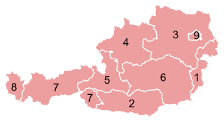
Deutsch: Karte der Bundesländer Österreichs.
English: Map of the States of Austria.
Français : Carte des Länder autrichiens.
Svenska: Karta över Österrikes förbundsländer. |
|||
| Tarehe | ||||
| Chanzo |
This file was derived from: Karte A Wien.svg |
|||
| Mwandishi |
Original: Vector: . |
|||
| Ruhusa (Kutumia faili tena) |
|
|||
| SVG genesis | This vector image was created with unknown tool.
|


Historia ya faili
Bonyeza tarehe/saa kuona faili kama ilivyoonekana wakati huo.
| Tarehe/Saa | Picha ndogo | Vipimo | Mtumiaji | Maelezo | |
|---|---|---|---|---|---|
| sasa hivi | 00:41, 25 Desemba 2012 | | 512 × 280 (68 KB) | GeMet | {{Information |Description = {{de|Karte der Bundesländer Österreichs.}} {{en|Map of the States of Austria.}} {{fr|Carte des Länder autrichiens.}} {{sv|Karta öve... |
Matumizi ya faili
Ukurasa huu umeunganishwa na faili hili:
Matumizi ya faili ulimwenguni
Wiki nyingine hutumia faili hizi:
- Matumizi kwa ami.wikipedia.org
- Matumizi kwa an.wikipedia.org
- Matumizi kwa ar.wikipedia.org
- Matumizi kwa azb.wikipedia.org
- Matumizi kwa az.wikipedia.org
- Matumizi kwa ba.wikipedia.org
- Matumizi kwa be-tarask.wikipedia.org
- Matumizi kwa be.wikipedia.org
- Matumizi kwa bs.wikipedia.org
- Matumizi kwa ca.wikipedia.org
- Matumizi kwa cs.wikipedia.org
- Matumizi kwa de.wikipedia.org
- Matumizi kwa de.wikinews.org
- Matumizi kwa el.wikipedia.org
- Matumizi kwa eml.wikipedia.org
- Matumizi kwa en.wikipedia.org
- Matumizi kwa eo.wikipedia.org
- Matumizi kwa es.wikipedia.org
- Matumizi kwa et.wikipedia.org
- Matumizi kwa eu.wikipedia.org
- Matumizi kwa fa.wikipedia.org
- Matumizi kwa frr.wikipedia.org
- Matumizi kwa fr.wikipedia.org
- Matumizi kwa gag.wikipedia.org
- Matumizi kwa gd.wikipedia.org
- Matumizi kwa gl.wikipedia.org
- Matumizi kwa he.wikipedia.org
Tazama matumizi zaidi ya kimataifa ya faili hii.