Faili:Şanlıurfa districts.png
Ukubwa wa hakikisho: piseli 788 × 600. Ukubwa zingine: piseli 315 × 240 | piseli 631 × 480 | piseli 1,010 × 769.
Faili halisi (piseli 1,010 × 769, saizi ya faili: 27 KB, aina ya MIME: image/png)
| Faili hili linatoka Wikimedia Commons. Maelezo yapo kule kwenye ukurasa wake wa maelezo unaonekana hapo chini.
|

|
This locator map image could be re-created using vector graphics as an SVG file. This has several advantages; see Commons:Media for cleanup for more information. If an SVG form of this image is available, please upload it and afterwards replace this template with
{{vector version available|new image name}}.
It is recommended to name the SVG file “Şanlıurfa districts.svg”—then the template Vector version available (or Vva) does not need the new image name parameter. |
Muhtasari
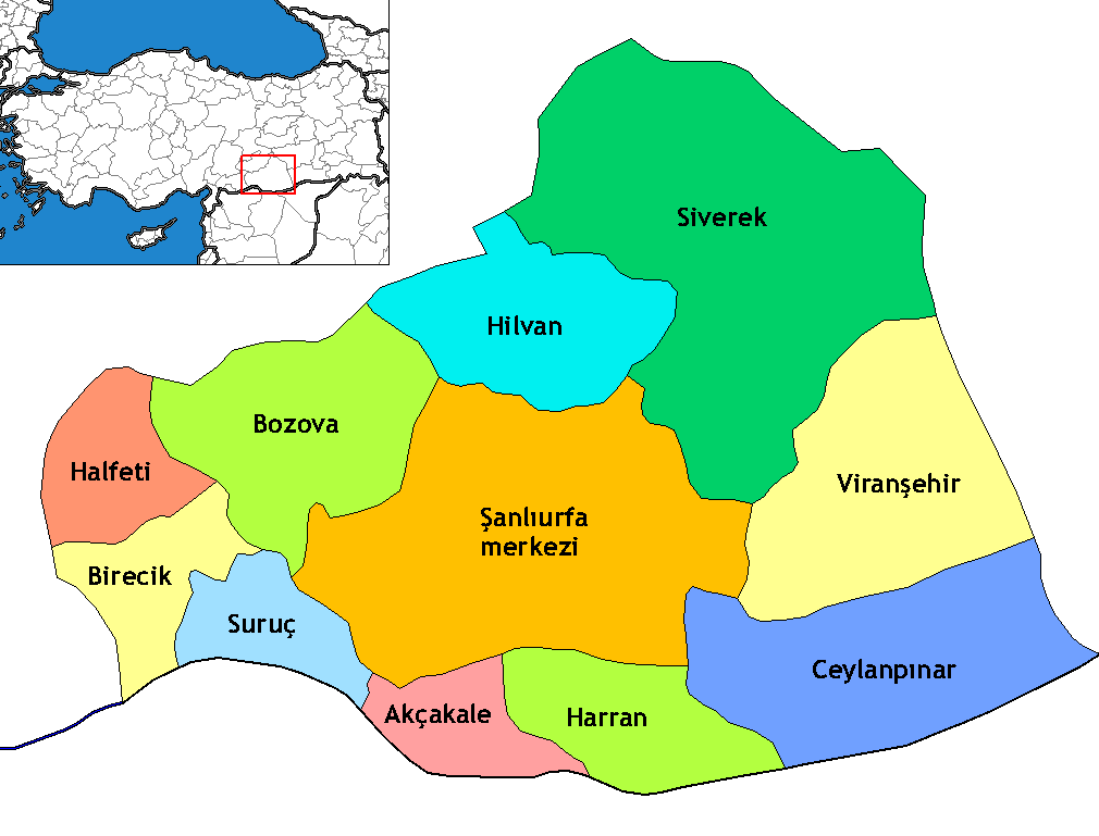
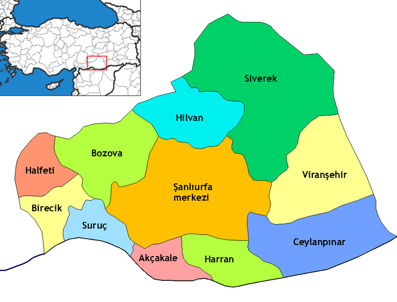
Map of the districts of Şanlıurfa province in Turkey. Created by Rarelibra 17:13, 4 December 2006 (UTC) for public domain use, using MapInfo Professional v8.5 and various mapping resources. Edited by One Homo Sapiens Corrected text where İ,Ş,ı,ğ,or ş occurs in name. Source: [statoids-com]. Increased font size and enhanced color differences among adjacent districts.
Hatimiliki
I, the copyright holder of this work, hereby publish it under the following license:
This file is licensed under the Creative Commons Attribution-Share Alike 2.5 Generic license.
- Uko huru:
- kushiriki – kunakili na kusambaza kazi hiyo
- kwa remix – kurekebisha kazi
- Chini ya masharti yafuatayo:
- sifa – Ni lazima utoe mkopo unaofaa, utoe kiungo cha leseni, na uonyeshe ikiwa mabadiliko yalifanywa. Unaweza kufanya hivyo kwa njia yoyote inayofaa, lakini si kwa njia yoyote inayopendekeza mtoa leseni akuidhinishe wewe au matumizi yako.
Historia ya faili
Bonyeza tarehe/saa kuona faili kama ilivyoonekana wakati huo.
| Tarehe/Saa | Picha ndogo | Vipimo | Mtumiaji | Maelezo | |
|---|---|---|---|---|---|
| sasa hivi | 01:19, 6 Novemba 2009 | | 1,010 × 769 (27 KB) | ZooFari | Trimmed |
| 02:29, 29 Desemba 2008 |  | 1,056 × 816 (28 KB) | One Homo Sapiens | Corrected text where İ,Ş,ı,ğ,or ş occurs in name. Source: [statoids-com]. Increased font size and enhanced color differences among adjacent districts. | |
| 22:03, 15 Aprili 2007 |  | 1,056 × 816 (33 KB) | Denizz~commonswiki | == Summary == Map of the districts of Şanlıurfa province in Turkey. Created by Rarelibra 17:13, 4 December 2006 (UTC) for public domain use, using MapInfo Professional v8.5 and various mapping resources. == Licensing == {{self|cc-by-s |
Matumizi ya faili
Kurasa hizi 11 zimeunganishwa na faili hili:
Matumizi ya faili ulimwenguni
Wiki nyingine hutumia faili hizi:
- Matumizi kwa ar.wikipedia.org
- Matumizi kwa ast.wikipedia.org
- Matumizi kwa avk.wikipedia.org
- Matumizi kwa ca.wikipedia.org
- Matumizi kwa diq.wikipedia.org
- Qori
- Babıci
- Şablon:Karber Sêwrege
- Şablon:Karber Rıha
- Alan, Sêwrege
- Alanqoz
- Anazo
- Arastul
- Axsun
- Bab
- Babvêren
- Bahser
- Sahrık
- İniyoderg
- Tıl
- Xırabrês
- Hop, Sêwrege
- Modan, Sêwrege
- Mextele
- Qetine
- Hadro
- Kelosk
- Kolik
- Baxce
- Benek
- Bexdes
- Bideri
- Boxcık
- Bitik
- Buxdikan
- Catax
- Celkani
- Celtug
- Dewık (Sêwrege)
- Alangoza Cêri
- Cepni
- Cımo qelısi
- Daragon
- Dinar (dewe)
- Gerisar
- Bılerız
- Qışlan
- Herheri
- Xalokend
- Salıcan
- Xarzeno
Tazama matumizi zaidi ya kimataifa ya faili hii.