Faili:Akiaki Island - Map.jpg

Ukubwa wa hakikisho: piseli 800 × 582. Ukubwa zingine: piseli 320 × 233 | piseli 640 × 466 | piseli 1,024 × 745 | piseli 1,240 × 902.
Faili halisi (piseli 1,240 × 902, saizi ya faili: 111 KB, aina ya MIME: image/jpeg)
| Faili hili linatoka Wikimedia Commons. Maelezo yapo kule kwenye ukurasa wake wa maelezo unaonekana hapo chini.
|

|
This map image could be re-created using vector graphics as an SVG file. This has several advantages; see Commons:Media for cleanup for more information. If an SVG form of this image is available, please upload it and afterwards replace this template with
{{vector version available|new image name}}.
It is recommended to name the SVG file “Akiaki Island - Map.svg”—then the template Vector version available (or Vva) does not need the new image name parameter. |


Muhtasari
| Maelezo |
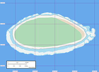
English: Map of Akiaki Island, Tuamotu Archipelago, French Polynesia.
Reef awash
Reef shallow
Land sand
Vegetation forest
Vegetation arid |
| Tarehe | |
| Chanzo | Akiaki Island - Map |
| Mwandishi | Mr Minton from San Diego, US |
Hatimiliki
This file is licensed under the Creative Commons Attribution 2.0 Generic license.
- Uko huru:
- kushiriki – kunakili na kusambaza kazi hiyo
- kwa remix – kurekebisha kazi
- Chini ya masharti yafuatayo:
- sifa – Ni lazima utoe mkopo unaofaa, utoe kiungo cha leseni, na uonyeshe ikiwa mabadiliko yalifanywa. Unaweza kufanya hivyo kwa njia yoyote inayofaa, lakini si kwa njia yoyote inayopendekeza mtoa leseni akuidhinishe wewe au matumizi yako.
| This image, originally posted to Flickr, was reviewed on 9 June 2008 by the administrator or reviewer Jonny-mt, who confirmed that it was available on Flickr under the stated license on that date. |
Historia ya faili
Bonyeza tarehe/saa kuona faili kama ilivyoonekana wakati huo.
| Tarehe/Saa | Picha ndogo | Vipimo | Mtumiaji | Maelezo | |
|---|---|---|---|---|---|
| sasa hivi | 08:45, 9 Juni 2008 | | 1,240 × 902 (111 KB) | Vriullop | {{Information |Description= {{en|Map of Akiaki, Tuamotu Archipelago, French Polynesia. {{legend|#edf3f3|Reef awash}} {{legend|#a9dcef|Reef shallow}} {{legend|#f7f4ef|Land sand}} {{legend|#aedab6|Vegetation forest}} {{legend|#e9dac5|Vegetation arid}}}} |So |
Matumizi ya faili
Ukurasa huu umeunganishwa na faili hili:
Matumizi ya faili ulimwenguni
Wiki nyingine hutumia faili hizi:
- Matumizi kwa az.wikipedia.org
- Matumizi kwa ca.wikipedia.org
- Matumizi kwa de.wikipedia.org
- Matumizi kwa en.wikipedia.org
- Matumizi kwa es.wikipedia.org
- Matumizi kwa fi.wikipedia.org
- Matumizi kwa fr.wikipedia.org
- Matumizi kwa gl.wikipedia.org
- Matumizi kwa it.wikipedia.org
- Matumizi kwa nl.wikipedia.org
- Matumizi kwa pt.wikipedia.org
- Matumizi kwa ru.wikipedia.org
- Matumizi kwa sk.wikipedia.org
- Matumizi kwa ty.wikipedia.org
- Matumizi kwa www.wikidata.org
- Matumizi kwa zh.wikipedia.org