Faili:Arshakuni Armenia 150-en.svg

Size of this PNG preview of this SVG file: piseli 800 × 470. Ukubwa zingine: piseli 320 × 188 | piseli 640 × 376 | piseli 1,024 × 601 | piseli 1,280 × 751 | piseli 2,560 × 1,503 | piseli 2,717 × 1,595.
Faili halisi (faili la SVG, husemwa kuwa piseli 2,717 × 1,595, saizi ya faili: 850 KB)
| Faili hili linatoka Wikimedia Commons. Maelezo yapo kule kwenye ukurasa wake wa maelezo unaonekana hapo chini.
|
Muhtasari
| Maelezo |
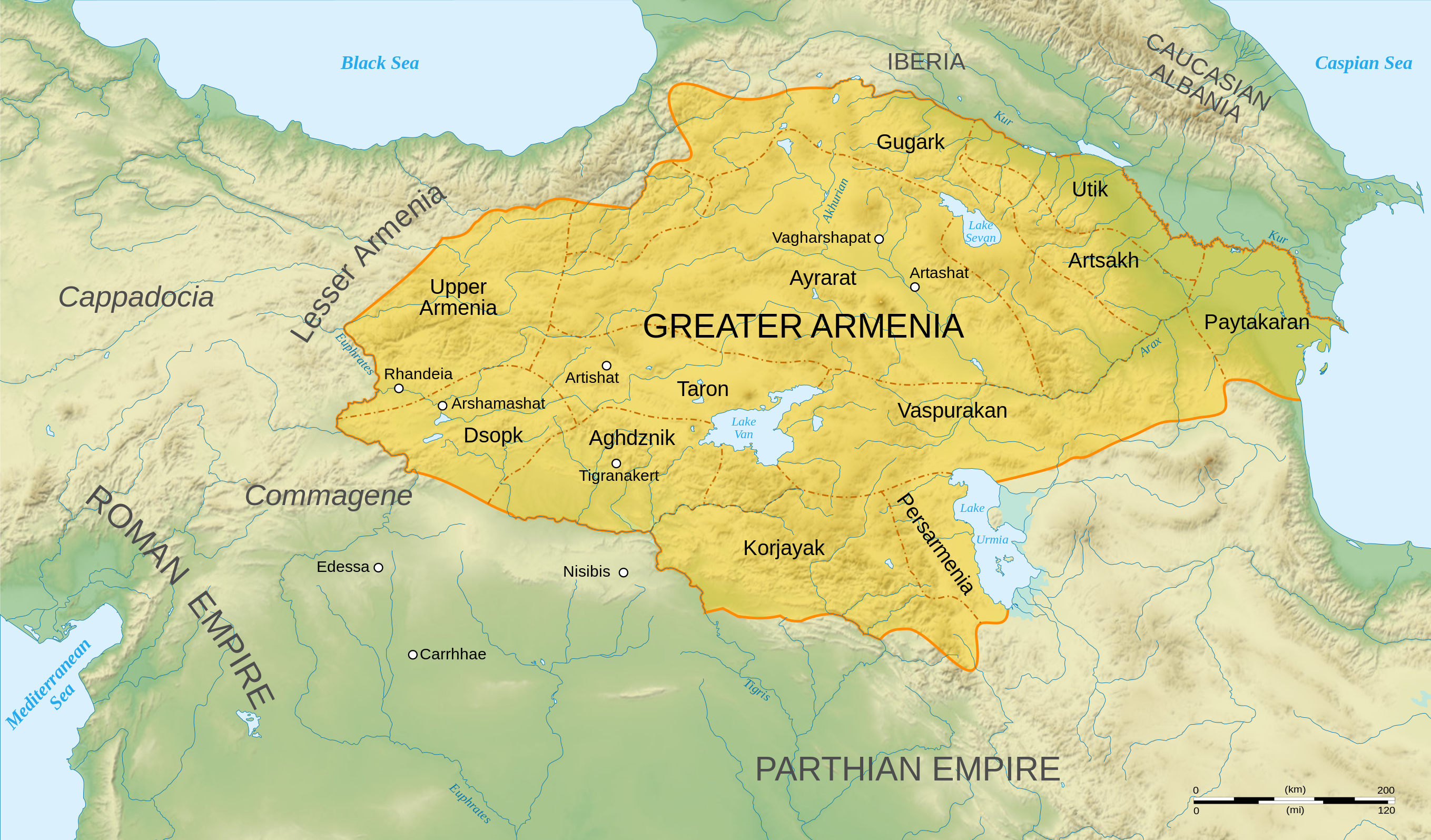
English: Map of Arshakuni Armenia, around the year 150 AD.
Français : Carte en anglais de l'Arménie Arsacide, vers l'an 150. |
||
| Tarehe | |||
| Chanzo |
Own work.
Sources :
Software used :
Autres données :
|
||
| Mwandishi | Sémhur | ||
| Matoleo mengine |
[]
| ||
| Sifa (required by the license) | © Sémhur / Wikimedia Commons / | ||
| SVG | W3C-validity not checked.
|
||
| Atelier graphique |


.png)


| Camera location | | View this and other nearby images on: OpenStreetMap |
|---|
Hatimiliki
I, the copyright holder of this work, hereby publish it under the following licenses:
| Copyleft: This work of art is free; you can redistribute it and/or modify it according to terms of the Free Art License. You will find a specimen of this license on the Copyleft Attitude site as well as on other sites. |
This file is licensed under the Creative Commons Attribution-Share Alike 4.0 International, 3.0 Unported, 2.5 Generic, 2.0 Generic and 1.0 Generic license.
- Uko huru:
- kushiriki – kunakili na kusambaza kazi hiyo
- kwa remix – kurekebisha kazi
- Chini ya masharti yafuatayo:
- sifa – Ni lazima utoe mkopo unaofaa, utoe kiungo cha leseni, na uonyeshe ikiwa mabadiliko yalifanywa. Unaweza kufanya hivyo kwa njia yoyote inayofaa, lakini si kwa njia yoyote inayopendekeza mtoa leseni akuidhinishe wewe au matumizi yako.
Unaweza kuchagua leseni ya chaguo lako.
Historia ya faili
Bonyeza tarehe/saa kuona faili kama ilivyoonekana wakati huo.
| Tarehe/Saa | Picha ndogo | Vipimo | Mtumiaji | Maelezo | |
|---|---|---|---|---|---|
| sasa hivi | 04:22, 30 Juni 2023 | | 2,717 × 1,595 (850 KB) | Luckie Luke | File uploaded using svgtranslate tool (https://svgtranslate.toolforge.org/). Added translation for fa. |
| 01:54, 30 Juni 2023 |  | 2,717 × 1,595 (808 KB) | Luckie Luke | File uploaded using svgtranslate tool (https://svgtranslate.toolforge.org/). Added translation for fa. | |
| 12:47, 12 Januari 2008 |  | 2,717 × 1,595 (798 KB) | Sémhur | == Description == {{Information |Description= {{en| Map of Arshakuni Armenia, around the year 150 AD.}} {{fr| Carte en anglais de l'Arménie Arsacide, vers l'an 150.}} |Source=Own work. {{clr}} Sources : * Topographic background : [http://www2.jpl.nasa.go |
Matumizi ya faili
Ukurasa huu umeunganishwa na faili hili:
Matumizi ya faili ulimwenguni
Wiki nyingine hutumia faili hizi:
- Matumizi kwa ar.wikipedia.org
- Matumizi kwa arz.wikipedia.org
- Matumizi kwa azb.wikipedia.org
- Matumizi kwa bg.wikipedia.org
- Matumizi kwa bn.wikipedia.org
- Matumizi kwa de.wikipedia.org
- Matumizi kwa diq.wikipedia.org
- Matumizi kwa el.wikipedia.org
- Χοσρόης Α΄ της Αρμενίας
- Τιριδάτης Β΄ της Αρμενίας
- Χοσρόης Β΄ της Αρμενίας
- Τιριδάτης Γ΄ της Αρμενίας
- Χοσρόης Γ΄ της Αρμενίας
- Τιράν της Αρμενίας
- Αρσάκης Β΄ της Αρμενίας
- Παπ της Αρμενίας
- Βαρασδάτης της Αρμενίας
- Αρσάκης Γ΄ της Αρμενίας
- Χοσρόης Δ΄ της Αρμενίας
- Βραχμσαπώρ της Αρμενίας
- Αρταξίας Δ΄ της Αρμενίας
- Τιγράνης ΣΤ΄ της Αρμενίας
- Τιριδάτης Α΄ της Αρμενίας
- Βολογέσης Γ΄ της Παρθίας
- Πρότυπο:Δυναστεία των Αρσακιδών της Αρμενίας
- Δυναστεία των Αρσακιδών της Αρμενίας
- Άνω Αρμενία
- Αρζανηνή
- Γογαρινή
- Matumizi kwa en.wikipedia.org
- Matumizi kwa en.wiktionary.org
- Matumizi kwa eo.wikipedia.org
Tazama matumizi zaidi ya kimataifa ya faili hii.