Faili:Bjornoya Location Map-en.svg

Size of this PNG preview of this SVG file: piseli 478 × 600. Ukubwa zingine: piseli 191 × 240 | piseli 383 × 480 | piseli 612 × 768 | piseli 816 × 1,024 | piseli 1,632 × 2,048 | piseli 1,010 × 1,267.
Faili halisi (faili la SVG, husemwa kuwa piseli 1,010 × 1,267, saizi ya faili: 242 KB)
| Faili hili linatoka Wikimedia Commons. Maelezo yapo kule kwenye ukurasa wake wa maelezo unaonekana hapo chini.
|
Muhtasari
| Maelezo |
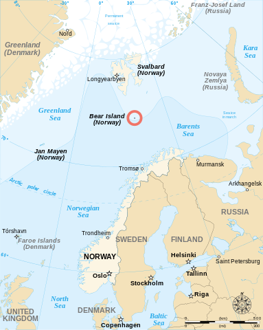
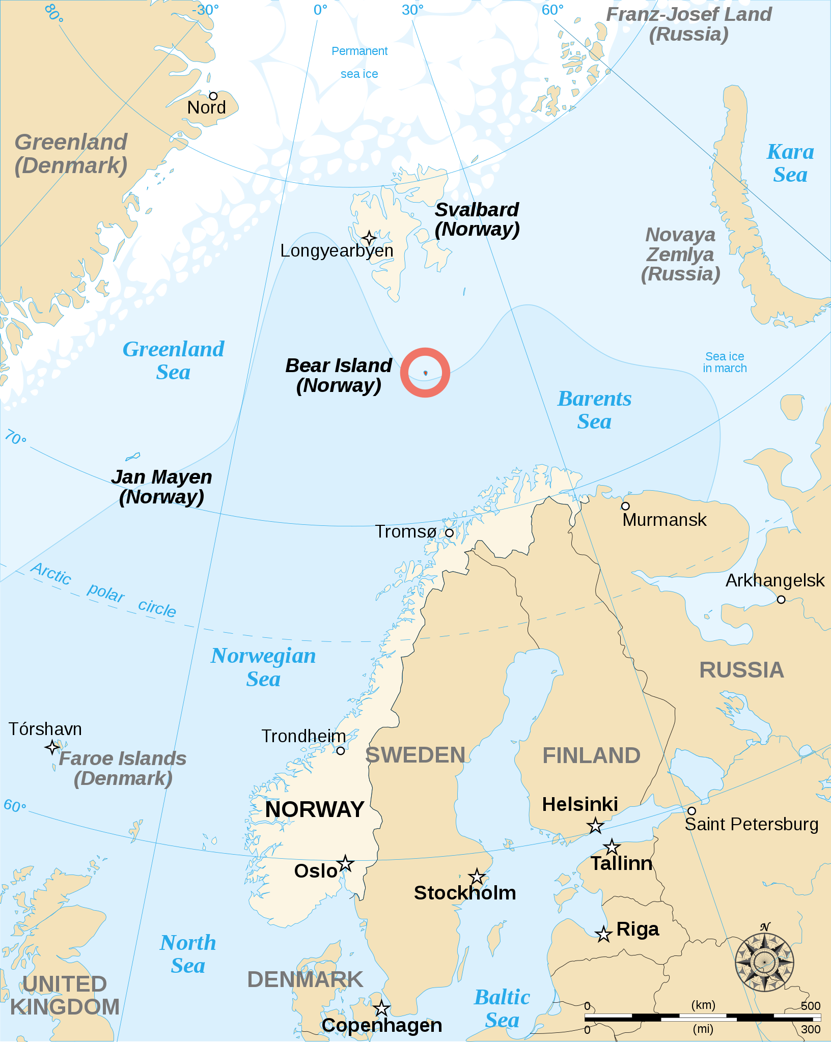
English: English map showing the location of Bear Island (Bjørnøya), a Norwegian island between Norway and Svalbard. Español: Carta en inglés con Bear Island (la isla del Oso). Français : Carte en anglais montrant l'emplacement de l'île aux Ours (Bjørnøya en norvégien), située entre la Norvège et l'archipel de Svalbard. |
||
| Tarehe | |||
| Chanzo | |||
| Mwandishi | Sémhur | ||
| Matoleo mengine |
[]
|
||
| Sifa (required by the license) | © Sémhur / Wikimedia Commons / | ||
| SVG | W3C-validity not checked.
|
||
| Atelier graphique |


| Camera location | | View this and other nearby images on: OpenStreetMap |
|---|
Hatimiliki
I, the copyright holder of this work, hereby publish it under the following licenses:
| Copyleft: This work of art is free; you can redistribute it and/or modify it according to terms of the Free Art License. You will find a specimen of this license on the Copyleft Attitude site as well as on other sites. |
This file is licensed under the Creative Commons Attribution-Share Alike 4.0 International, 3.0 Unported, 2.5 Generic, 2.0 Generic and 1.0 Generic license.
- Uko huru:
- kushiriki – kunakili na kusambaza kazi hiyo
- kwa remix – kurekebisha kazi
- Chini ya masharti yafuatayo:
- sifa – Ni lazima utoe mkopo unaofaa, utoe kiungo cha leseni, na uonyeshe ikiwa mabadiliko yalifanywa. Unaweza kufanya hivyo kwa njia yoyote inayofaa, lakini si kwa njia yoyote inayopendekeza mtoa leseni akuidhinishe wewe au matumizi yako.
Unaweza kuchagua leseni ya chaguo lako.
Historia ya faili
Bonyeza tarehe/saa kuona faili kama ilivyoonekana wakati huo.
| Tarehe/Saa | Picha ndogo | Vipimo | Mtumiaji | Maelezo | |
|---|---|---|---|---|---|
| sasa hivi | 12:48, 17 Mei 2013 | | 1,010 × 1,267 (242 KB) | Sémhur | Correcting svg bugs |
| 14:00, 2 Novemba 2007 |  | 1,010 × 1,267 (242 KB) | Sémhur | {{Information| Description= {{en}}English map showing the location of Bjørnøya (''Bear Island'' in English), an island between Norway and Svalbard. {{fr}}Carte en anglais montrant la localisation de l'île aux Ours (''Bjørnøya'' en Norvégien), situ� |
Matumizi ya faili
Ukurasa huu umeunganishwa na faili hili:
Matumizi ya faili ulimwenguni
Wiki nyingine hutumia faili hizi:
- Matumizi kwa ar.wikipedia.org
- Matumizi kwa br.wikipedia.org
- Matumizi kwa de.wikipedia.org
- Matumizi kwa en.wikipedia.org
- Matumizi kwa es.wikipedia.org
- Matumizi kwa fa.wikipedia.org
- Matumizi kwa fo.wikipedia.org
- Matumizi kwa fy.wikipedia.org
- Matumizi kwa gl.wikipedia.org
- Matumizi kwa hr.wikipedia.org
- Matumizi kwa li.wikipedia.org
- Matumizi kwa nl.wikipedia.org
- Matumizi kwa nn.wikipedia.org
- Matumizi kwa sk.wikipedia.org
- Matumizi kwa sl.wikipedia.org
- Matumizi kwa sr.wikipedia.org
- Matumizi kwa sv.wikipedia.org
- Matumizi kwa uk.wikipedia.org
- Matumizi kwa ur.wikipedia.org