Faili:Bo-map.png
Hakuna saizi kubwa zaidi.
Bo-map.png (piseli 330 × 355, saizi ya faili: 11 KB, aina ya MIME: image/png)
| Faili hili linatoka Wikimedia Commons. Maelezo yapo kule kwenye ukurasa wake wa maelezo unaonekana hapo chini.
|
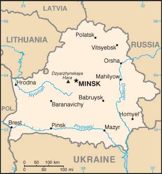
Belarus map from CIA World Factbook
This image is in the public domain because it contains materials that originally came from the United States Central Intelligence Agency's World Factbook.
|
 |

|
This map image could be re-created using vector graphics as an SVG file. This has several advantages; see Commons:Media for cleanup for more information. If an SVG form of this image is available, please upload it and afterwards replace this template with
{{vector version available|new image name}}.
It is recommended to name the SVG file “Bo-map.svg”—then the template Vector version available (or Vva) does not need the new image name parameter. |
Historia ya faili
Bonyeza tarehe/saa kuona faili kama ilivyoonekana wakati huo.
| Tarehe/Saa | Picha ndogo | Vipimo | Mtumiaji | Maelezo | |
|---|---|---|---|---|---|
| sasa hivi | 20:28, 27 Novemba 2004 | | 330 × 355 (11 KB) | Kneiphof | CIA Belarus map |
Matumizi ya faili
Kurasa hizi 2 zimeunganishwa na faili hili:
Matumizi ya faili ulimwenguni
Wiki nyingine hutumia faili hizi:
- Matumizi kwa be.wikipedia.org
- Matumizi kwa bg.wikipedia.org
- Matumizi kwa bn.wikipedia.org
- Matumizi kwa bs.wikipedia.org
- Matumizi kwa dsb.wikipedia.org
- Matumizi kwa el.wikipedia.org
- Matumizi kwa en.wikipedia.org
- Matumizi kwa es.wikipedia.org
- Matumizi kwa eu.wikipedia.org
- Matumizi kwa fa.wikipedia.org
- Matumizi kwa ff.wikipedia.org
- Matumizi kwa gag.wikipedia.org
- Matumizi kwa hu.wikipedia.org
- Matumizi kwa hu.wiktionary.org
- Matumizi kwa ka.wikipedia.org
- Matumizi kwa ko.wikipedia.org
- Matumizi kwa mk.wikipedia.org
- Matumizi kwa mn.wikipedia.org
- Matumizi kwa mr.wikipedia.org
- Matumizi kwa nap.wikipedia.org
- Matumizi kwa nl.wiktionary.org
- Matumizi kwa nn.wikipedia.org
- Matumizi kwa no.wikipedia.org
- Matumizi kwa ro.wikipedia.org
- Matumizi kwa ru.wikipedia.org
- Matumizi kwa ru.wiktionary.org
- Matumizi kwa sh.wikipedia.org
- Matumizi kwa simple.wikipedia.org
- Matumizi kwa sl.wikipedia.org
- Matumizi kwa sr.wikipedia.org
- Matumizi kwa th.wikipedia.org
- Matumizi kwa tr.wikipedia.org
- Matumizi kwa udm.wikipedia.org
- Matumizi kwa uk.wikipedia.org
- Matumizi kwa xmf.wikipedia.org
- Matumizi kwa zh.wikipedia.org