Faili:Bulgaria Simeon I (893-927).svg

Size of this PNG preview of this SVG file: piseli 627 × 599. Ukubwa zingine: piseli 251 × 240 | piseli 502 × 480 | piseli 803 × 768 | piseli 1,071 × 1,024 | piseli 2,142 × 2,048 | piseli 752 × 719.
Faili halisi (faili la SVG, husemwa kuwa piseli 752 × 719, saizi ya faili: 232 KB)
| Faili hili linatoka Wikimedia Commons. Maelezo yapo kule kwenye ukurasa wake wa maelezo unaonekana hapo chini.
|
| Maelezo | |
| Tarehe | created and uploaded 4 March 2007 |
| Chanzo | Kazi yangu |
| Mwandishi | Todor Bozhinov |
| Ruhusa (Kutumia faili tena) |
This file is licensed under the Creative Commons Attribution-Share Alike 2.5 Generic license.
|
| Matoleo mengine |
[]
|
cs.png)
.png)
.svg)
_es.svg)
-hu.svg)
_pt.svg)
-zh.svg)
-ar.svg)
.svg)
Notes
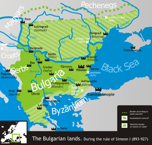
- 1 According to, among others, Crampton, Delev, Dobrev and Lalkov.
- 2 Bulgaria ruled all land east of the Danube and west of the Dnieper according to Constantine VII's De Administrando Imperio (c. 950), but actual Bulgarian control was often partial, weak and/or inconsistent in many of the scarcely-populated areas north of the Danube.
- 3 That is, unconfirmed by a peace treaty and only controlled during military campaigns in the Byzantine lands. These, however, comprised much if not most of Simeon's rule.
- The northern border is conjectural, as its exact location is practically unattested.
References
- Crampton, R.J. (2005) A Concise History of Bulgaria, Cambridge University Press, pp. p. 13 ISBN 0521850851
- Delev, Petǎr; Valeri Kacunov, Plamen Mitev, Evgenija Kalinova, Iskra Baeva, Bojan Dobrev (2006) "9 Bǎlgarskata dǎržava pri Car Simeon" in (bulgarian) Istorija i civilizacija za 11. klas, Trud, Sirma
- Dobrev, Hristo (1979) (bulgarian) Bǎlgarski voenen atlas, Sofia: Voenno izdatelstvo, pp. pp. 152−153 OCLC 46136451
- Koledarov, Petǎr (1989) (bulgarian) Političeska geografija na srednovekovnata bǎlgarska dǎržava 2 (1186–1396), Bulgarian Academy of Sciences
- Lalkov, Milčo (1997) Rulers of Bulgaria, Kibea, pp. p. 24, p. 66 ISBN 954-474-098-8
| Annotations | This image is annotated: View the annotations at Commons |
Historia ya faili
Bonyeza tarehe/saa kuona faili kama ilivyoonekana wakati huo.
.svg&dir=prev)
.svg&offset=20070304205903)
.svg&offset=&limit=20)
.svg&offset=&limit=50)
.svg&offset=&limit=100)
.svg&offset=&limit=250)
.svg&offset=&limit=500)
| Tarehe/Saa | Picha ndogo | Vipimo | Mtumiaji | Maelezo | |
|---|---|---|---|---|---|
| sasa hivi | 14:50, 18 Novemba 2019 | | 752 × 719 (232 KB) | Claude Zygiel | Side |
| 14:49, 18 Novemba 2019 |  | 744 × 1,052 (520 KB) | Claude Zygiel | Details | |
| 20:38, 18 Februari 2011 |  | 752 × 719 (232 KB) | Ilmari Karonen | add missing xmlns attribute(s) | |
| 20:49, 7 Machi 2007 | Hakuna picha ndogo | (232 KB) | Martyr | ||
| 09:13, 6 Machi 2007 | Hakuna picha ndogo | (232 KB) | Martyr | ||
| 21:10, 5 Machi 2007 | Hakuna picha ndogo | (230 KB) | Martyr | ||
| 20:03, 5 Machi 2007 | Hakuna picha ndogo | (230 KB) | Martyr | larger names of battles, etc. | |
| 19:29, 5 Machi 2007 | Hakuna picha ndogo | (232 KB) | Martyr | names of some important battles, etc. | |
| 10:22, 5 Machi 2007 | Hakuna picha ndogo | (211 KB) | Martyr | river names, Thessaloniki name, rm line (northern border is conjectural), etc. | |
| 20:59, 4 Machi 2007 | Hakuna picha ndogo | (194 KB) | Martyr | new |
Matumizi ya faili
Ukurasa huu umeunganishwa na faili hili:
Matumizi ya faili ulimwenguni
Wiki nyingine hutumia faili hizi:
- Matumizi kwa ar.wikipedia.org
- Matumizi kwa bn.wikipedia.org
- Matumizi kwa ckb.wikipedia.org
- Matumizi kwa da.wikipedia.org
- Matumizi kwa de.wikipedia.org
- Matumizi kwa el.wikipedia.org
- Matumizi kwa en.wikipedia.org
- Matumizi kwa eo.wikipedia.org
- Matumizi kwa es.wikipedia.org
- Matumizi kwa eu.wikipedia.org
- Matumizi kwa fa.wikipedia.org
- Matumizi kwa fr.wikipedia.org
- Matumizi kwa he.wikipedia.org
- Matumizi kwa hr.wikipedia.org
- Matumizi kwa hy.wikipedia.org
- Matumizi kwa it.wikipedia.org
- Matumizi kwa ja.wikipedia.org
- Matumizi kwa ka.wikipedia.org
- Matumizi kwa kk.wikipedia.org
- Matumizi kwa lt.wikipedia.org
- Matumizi kwa lv.wikipedia.org
- Matumizi kwa mk.wikipedia.org
- Matumizi kwa nds.wikipedia.org
- Matumizi kwa nl.wikipedia.org
- Matumizi kwa no.wikipedia.org
- Matumizi kwa oc.wikipedia.org
- Matumizi kwa pl.wikipedia.org
- Matumizi kwa pt.wikipedia.org
Tazama matumizi zaidi ya kimataifa ya faili hii.
.svg)
.svg)