Faili:Dallas County Texas Incorporated Areas Grand Prairie highighted.svg

Size of this PNG preview of this SVG file: piseli 800 × 457. Ukubwa zingine: piseli 320 × 183 | piseli 640 × 366 | piseli 1,024 × 585 | piseli 1,280 × 731 | piseli 2,560 × 1,463.
Faili halisi (faili la SVG, husemwa kuwa piseli 1,050 × 600, saizi ya faili: 248 KB)
| Faili hili linatoka Wikimedia Commons. Maelezo yapo kule kwenye ukurasa wake wa maelezo unaonekana hapo chini.
|
Muhtasari
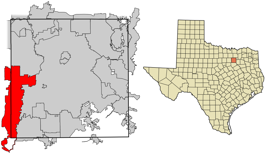
| Maelezo | This map shows the incorporated areas in Dallas County, Texas. Grand Prairie is highlighted in red. I created it in Inkscape using data from the following links: North Central Texas Council of Governments Maps Website, Dallas County Commissioner District Map (PDF) |
| Tarehe | |
| Chanzo | My own work, based on government information. Though I strove to be as accurate in the detail as possible, the information shown is not guaranteed to be completely accurate. |
| Mwandishi | Ixnayonthetimmay |
| Ruhusa (Kutumia faili tena) |
Public Domain |
| Matoleo mengine | See Category:Maps of Dallas County, Texas for other versions of this image. |
Hatimiliki
| I, the copyright holder of this work, release this work into the public domain. This applies worldwide. Katika nchi zingine hii haiwezekani kisheria; kama ni hivyo: I grant anyone the right to use this work for any purpose, without any conditions, unless such conditions are required by law. |
Historia ya faili
Bonyeza tarehe/saa kuona faili kama ilivyoonekana wakati huo.
| Tarehe/Saa | Picha ndogo | Vipimo | Mtumiaji | Maelezo | |
|---|---|---|---|---|---|
| sasa hivi | 18:39, 9 Agosti 2007 | | 1,050 × 600 (248 KB) | Ixnayonthetimmay | == Summary == {{Information |Description=This map shows the incorporated areas in Dallas County, Texas. Grand Prairie is highlighted in red. I created it in [[en: |
Matumizi ya faili
Ukurasa huu umeunganishwa na faili hili:
Matumizi ya faili ulimwenguni
Wiki nyingine hutumia faili hizi:
- Matumizi kwa ar.wikipedia.org
- Matumizi kwa arz.wikipedia.org
- Matumizi kwa ca.wikipedia.org
- Matumizi kwa ceb.wikipedia.org
- Matumizi kwa cy.wikipedia.org
- Matumizi kwa de.wikipedia.org
- Matumizi kwa en.wikipedia.org
- Matumizi kwa eo.wikipedia.org
- Matumizi kwa eu.wikipedia.org
- Matumizi kwa fa.wikipedia.org
- Matumizi kwa fr.wikipedia.org
- Matumizi kwa ga.wikipedia.org
- Matumizi kwa hr.wikipedia.org
- Matumizi kwa ht.wikipedia.org
- Matumizi kwa id.wikipedia.org
- Matumizi kwa it.wikipedia.org
- Matumizi kwa ja.wikipedia.org
- Matumizi kwa kab.wikipedia.org
- Matumizi kwa la.wikipedia.org
- Matumizi kwa mdf.wikipedia.org
- Matumizi kwa ml.wikipedia.org
- Matumizi kwa ms.wikipedia.org
- Matumizi kwa pl.wikipedia.org
- Matumizi kwa pnb.wikipedia.org
- Matumizi kwa pt.wikipedia.org
- Matumizi kwa ro.wikipedia.org
- Matumizi kwa simple.wikipedia.org
- Matumizi kwa sk.wikipedia.org
- Matumizi kwa sr.wikipedia.org
- Matumizi kwa tr.wikipedia.org
- Matumizi kwa tt.wikipedia.org
- Matumizi kwa ur.wikipedia.org
- Matumizi kwa vo.wikipedia.org
- Matumizi kwa www.wikidata.org
- Matumizi kwa zh.wikipedia.org