Faili:Denton County Texas Incorporated Areas Denton highlighted.svg

Size of this PNG preview of this SVG file: piseli 800 × 400. Ukubwa zingine: piseli 320 × 160 | piseli 640 × 320 | piseli 1,024 × 512 | piseli 1,280 × 640 | piseli 2,560 × 1,280 | piseli 1,050 × 525.
Faili halisi (faili la SVG, husemwa kuwa piseli 1,050 × 525, saizi ya faili: 370 KB)
| Faili hili linatoka Wikimedia Commons. Maelezo yapo kule kwenye ukurasa wake wa maelezo unaonekana hapo chini.
|
Muhtasari
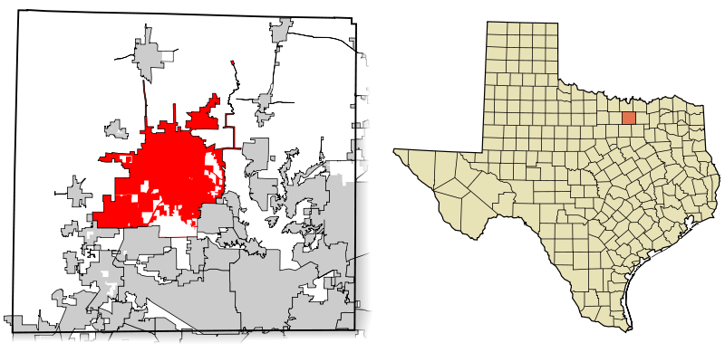
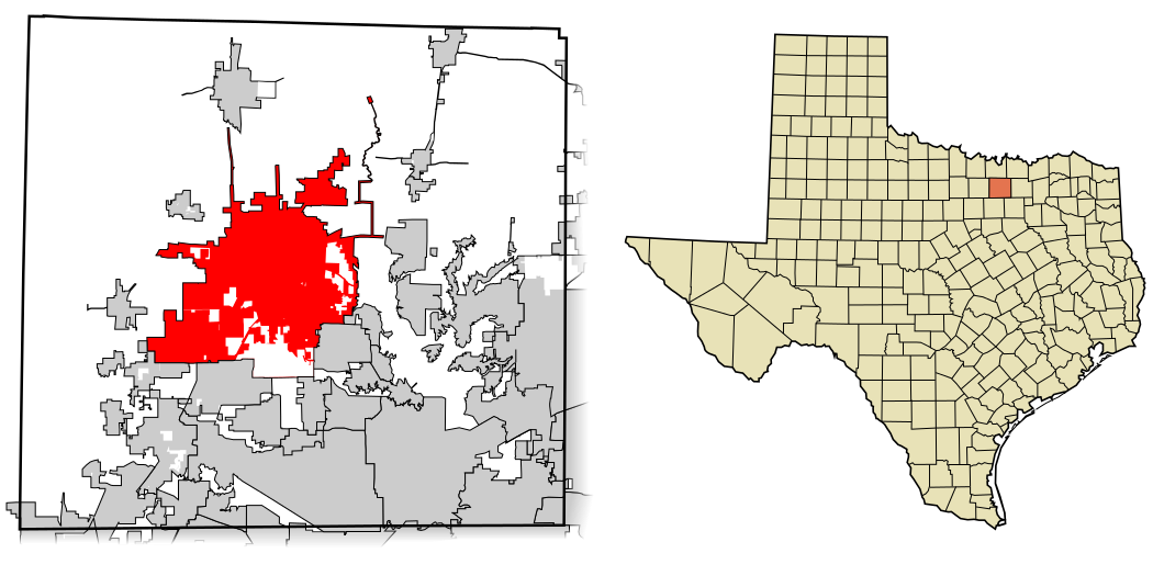
| Maelezo | This map shows the incorporated areas in Denton County, Texas. Denton is highlighted in red. I created it in Inkscape using data from the Denton County Planning & GIS Website) and the North Central Texas Council of Governments Website. |
| Tarehe | |
| Chanzo | My own work, based on government information. Though I strove to be as accurate in the detail as possible, the information isn't one hundred percent accurate. |
| Mwandishi | Ixnayonthetimmay |
| Ruhusa (Kutumia faili tena) |
Public Domain |
| Matoleo mengine | See Category:Maps of Denton County, Texas for other versions of this image. |
Hatimiliki
| I, the copyright holder of this work, release this work into the public domain. This applies worldwide. Katika nchi zingine hii haiwezekani kisheria; kama ni hivyo: I grant anyone the right to use this work for any purpose, without any conditions, unless such conditions are required by law. |
Historia ya faili
Bonyeza tarehe/saa kuona faili kama ilivyoonekana wakati huo.
| Tarehe/Saa | Picha ndogo | Vipimo | Mtumiaji | Maelezo | |
|---|---|---|---|---|---|
| sasa hivi | 05:34, 26 Februari 2008 | | 1,050 × 525 (370 KB) | Ixnayonthetimmay | == Summary == {{Information |Description=This map shows the incorporated areas in Denton County, Texas. Denton is highlighted in red. I created it in [[:en:Inkscape|Inks |
Matumizi ya faili
Ukurasa huu umeunganishwa na faili hili:
Matumizi ya faili ulimwenguni
Wiki nyingine hutumia faili hizi:
- Matumizi kwa ar.wikipedia.org
- Matumizi kwa arz.wikipedia.org
- Matumizi kwa bn.wikipedia.org
- Matumizi kwa ca.wikipedia.org
- Matumizi kwa ceb.wikipedia.org
- Matumizi kwa cy.wikipedia.org
- Matumizi kwa de.wikipedia.org
- Matumizi kwa en.wikipedia.org
- Matumizi kwa eo.wikipedia.org
- Matumizi kwa eu.wikipedia.org
- Matumizi kwa fa.wikipedia.org
- Matumizi kwa fi.wikipedia.org
- Matumizi kwa fr.wikipedia.org
- Matumizi kwa ga.wikipedia.org
- Matumizi kwa ht.wikipedia.org
- Matumizi kwa hu.wikipedia.org
- Matumizi kwa it.wikipedia.org
- Matumizi kwa ja.wikipedia.org
- Matumizi kwa ml.wikipedia.org
- Matumizi kwa no.wikipedia.org
- Matumizi kwa pnb.wikipedia.org
- Matumizi kwa sv.wikipedia.org
- Matumizi kwa tl.wikipedia.org
- Matumizi kwa tr.wikipedia.org
- Matumizi kwa tt.wikipedia.org
- Matumizi kwa ur.wikipedia.org
- Matumizi kwa vo.wikipedia.org
- Matumizi kwa www.wikidata.org
- Matumizi kwa zh-min-nan.wikipedia.org
- Matumizi kwa zh.wikipedia.org