Faili:Elam Map.jpg
Hakuna saizi kubwa zaidi.
Elam_Map.jpg (piseli 300 × 250, saizi ya faili: 28 KB, aina ya MIME: image/jpeg)
| Faili hili linatoka Wikimedia Commons. Maelezo yapo kule kwenye ukurasa wake wa maelezo unaonekana hapo chini.
|
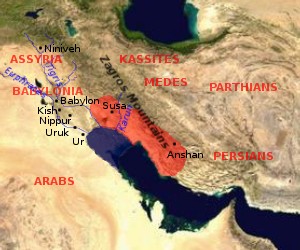
Map of Elam (approximate extension of the Elamite Empire is shown in red, the size of the Persian Gulf in the Bronze Age is indicated in blue (violet?))

|
Ruhusa inakubalika kunakili, kusambaza na/au kurekebisha chini ya matakwa ya GNU Free Documentation License, Toleo 1.2 au toleo lolote lile la baadaye ambalo litachapishwa na Free Software Foundation; lisilo na Sehemu Tofauti, lisilo na Maandishi-Kava-Kwa-Mbele, na lisilo na Maandishi-Kava-Kwa -Nyuma. Nakala ya hatimiliki inajumlishwa kwenye sehemu ilioitwa GNU Free Documentation License. |
| Faili hii imeidhinishwa chini ya Creative Commons Attribution- Attribution-Share Alike 3.0 Unported leseni. | ||
shiriki sawa – Ukichanganya, kubadilisha, au kujenga juu ya nyenzo, lazima usambaze michango yako chini ya same or compatible license kama ya awali. | ||
| This licensing tag was added to this file as part of the GFDL licensing update. |
by en:User:Dbachmann, based on [1] archive copy at the Wayback Machine, [2] archive copy at the Wayback Machine.


![[1]](http://www.zoroastriankids.com/map_elam.gif)
![[2]](http://home.columbus.rr.com/malyan/Resources/mesoiranmap.gif)
Historia ya faili
Bonyeza tarehe/saa kuona faili kama ilivyoonekana wakati huo.
| Tarehe/Saa | Picha ndogo | Vipimo | Mtumiaji | Maelezo | |
|---|---|---|---|---|---|
| sasa hivi | 09:01, 28 Julai 2005 | | 300 × 250 (28 KB) | Dbachmann | update |
| 08:18, 26 Julai 2005 |  | 300 × 250 (23 KB) | Dbachmann | Map of Elam {{GFDL}} by en:User:Dbachmann, based on [http://www.zoroastriankids.com/map_elam.gif], [http://home.columbus.rr.com/malyan/Resources/mesoiranmap.gif]. |
Matumizi ya faili
Ukurasa huu umeunganishwa na faili hili:
Matumizi ya faili ulimwenguni
Wiki nyingine hutumia faili hizi:
- Matumizi kwa af.wikipedia.org
- Matumizi kwa am.wikipedia.org
- Matumizi kwa ar.wikipedia.org
- Matumizi kwa av.wikipedia.org
- Matumizi kwa azb.wikipedia.org
- Matumizi kwa ba.wikipedia.org
- Matumizi kwa bg.wikipedia.org
- Matumizi kwa bn.wikipedia.org
- Matumizi kwa ca.wikipedia.org
- Matumizi kwa ckb.wikipedia.org
- Matumizi kwa cv.wikipedia.org
- Matumizi kwa da.wikipedia.org
- Matumizi kwa de.wikipedia.org
- Matumizi kwa diq.wikipedia.org
- Matumizi kwa el.wikipedia.org
- Matumizi kwa en.wikipedia.org
- Matumizi kwa es.wikipedia.org
- Matumizi kwa et.wikipedia.org
- Matumizi kwa eu.wikipedia.org
- Matumizi kwa fa.wikipedia.org
- Matumizi kwa fi.wikibooks.org
- Matumizi kwa fr.wikipedia.org
- Matumizi kwa gl.wikipedia.org
- Matumizi kwa he.wikipedia.org
- Matumizi kwa hi.wikipedia.org
- Matumizi kwa hr.wikipedia.org
- Matumizi kwa hu.wikipedia.org
Tazama matumizi zaidi ya kimataifa ya faili hii.