Faili:Europe map 1648.PNG
Faili halisi(piseli 1,894 × 1,367, saizi ya faili: 195 KB, aina ya MIME: image/png)

Faili hili linatoka Wikimedia Commons. Maelezo yapo kule kwenye ukurasa wake wa maelezo unaonekana hapo chini.
Commons ni mahali mtandaoni pa kuhifadhia jalada na hati za picha na sauti zenye leseni huria. Unaweza kuisadia.
This historical map image could be re-created using vector graphics as an SVG file. This has several advantages; see Commons:Media for cleanup for more information. If an SVG form of this image is available, please upload it and afterwards replace this template with {{vector version available|new image name}}.


It is recommended to name the SVG file “Europe map 1648.svg”—then the template Vector version available (or Vva) does not need the new image name parameter.

Muhtasari

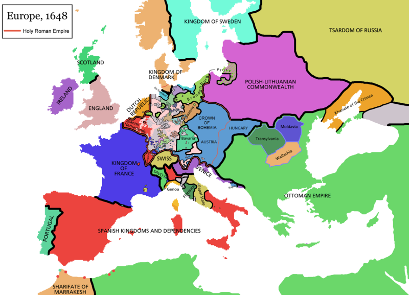
Map of Europe in 1648 (at the end of the Thirty Years War), based on free map of europe Image:BlankMap-Europe.png. Red line marks the border of the Holy Roman Empire. Information from Penguin atlas of modern history. (what year?)

Maps of the history of Europe
BCE
aC

Weichselian ice age (c. 113,000–9700) · Neolithic expansion (c. 7000–4500) · Middle Neolithic (c. 4500–4000) · Late Neolithic (c. 4000–3000) · Copper Age – Corded Ware culture (c. 2900–2350) · Copper Age – Bellbeaker culture (c. 2800–1800) · Early Bronze Age – Unetice culture (c. 2300–1600) · Late Bronze Age – Urnfield culture (c. 1300—750) · Migrations (c. 1000–100) · Hallstatt & La Tène cultures (c. 800–100) · Roman Republic (510–40) · 220 · 218 · 200 · 201–100 · 58 · 49 · 39 · 30 BCE–6 CE


CE
dC

14 · 14–37 · 60 · 60 · 69 · 80 · Migrations 100–500 · 117 · 117 · 125 · Migrations 150–774 · Economy 180 · 271 · 293–305 · 337 · 395 · c. 395 · 400 · 400 · 450 · 457–61 · 476 · 480 · Franks 481–814 · Early Slavs 500–700 · 500 · 526 · 526–600 · Christianisation to 600 · c. 550 · 650 · Pontic Steppe 650 · 665 · 800 · Vikings 800–1050 · 814 · 843–70 · 850 · 900 · 912 · 998 · 1000 · 1000 · 1054 · 1092 · First Crusade 1095–99 · 1097 · 1135 · 1142 · 1147–49 · 1190 · 1190 · 1250 · c. 1250 · 1301-1400 · 1301-1400 · 1328 · 1345 · Black Plague 1347–51 · 1360 · 1400 · Trade routes c. 1400 · 1430 · 1470 · 1490 · 1492 · 1500 · 1519 · 1550 · 1560 · Religion 1560 · Religion 1600 · Religion 1618 · 1618–48 · 1648 · 1683 · 1700 · 1701 · 1708 · 1714 · 1721 · 1725–30 · 1739–1740 · 1740 · 1748–66 · 1783–1792 · 1787 · 1787 · 1789 · 1799 · 1812 · 1812 · 1812 · 1812 · 1813 · 1815 · 1815 · 1815 · 1818 · Ottoman Empire 1830–1923 · 1848–49 · 1861 · 1867 · 1871 · 1878 · 1890 · 1905 · 1911 · 1914 · 1914 · 1919 · 1919–29 · 1923 · 1929 · 1930 · 1940 · 1941–42 · 1942–45 · Cold War 1947–91 · 1950 · 1993–2006 · 2006 to date

(this template: · view · discuss )


Hatimiliki

GNU head Ruhusa inakubalika kunakili, kusambaza na/au kurekebisha chini ya matakwa ya GNU Free Documentation License, Toleo 1.2 au toleo lolote lile la baadaye ambalo litachapishwa na Free Software Foundation; lisilo na Sehemu Tofauti, lisilo na Maandishi-Kava-Kwa-Mbele, na lisilo na Maandishi-Kava-Kwa -Nyuma. Nakala ya hatimiliki inajumlishwa kwenye sehemu ilioitwa GNU Free Documentation License.
w:en:Creative Commons
sifa shiriki sawa
Faili hii imeidhinishwa chini ya Creative Commons Attribution- Attribution-Share Alike 3.0 Unported leseni.
Uko huru:
  • kushiriki – kunakili na kusambaza kazi hiyo
  • kwa remix – kurekebisha kazi
Chini ya masharti yafuatayo:
  • sifa – Ni lazima utoe mkopo unaofaa, utoe kiungo cha leseni, na uonyeshe ikiwa mabadiliko yalifanywa. Unaweza kufanya hivyo kwa njia yoyote inayofaa, lakini si kwa njia yoyote inayopendekeza mtoa leseni akuidhinishe wewe au matumizi yako.

shiriki sawa – Ukichanganya, kubadilisha, au kujenga juu ya nyenzo, lazima usambaze michango yako chini ya same or compatible license kama ya awali.

This licensing tag was added to this file as part of the GFDL licensing update.

derivative works

Derivative works of this file:

Captions

Add a one-line explanation of what this file represents

Items portrayed in this file

depicts Kiingereza

copyright status Kiingereza

copyrighted Kiingereza

media type Kiingereza

image/png

Historia ya faili

Bonyeza tarehe/saa kuona faili kama ilivyoonekana wakati huo.

(mpya | zamani) Tazama (10 ya karibu zaidi | ) (10 | 20 | 50 | 100 | 250 | 500)
Tarehe/SaaPicha ndogoVipimoMtumiajiMaelezo
sasa hivi09:44, 14 Aprili 2021Picha ndogo ya toleo la 09:44, 14 Aprili 20211,894 × 1,367 (195 KB)TenanReverted to version as of 16:09, 12 October 2017 (UTC) See discussion
10:47, 9 Machi 2021Picha ndogo ya toleo la 10:47, 9 Machi 20211,894 × 1,367 (210 KB)TTBCamhReverted to version as of 17:18, 20 September 2018 (UTC). I don't know why Raderich is saying this is an arbitrary change—Catalonia was under the possession of the French king in 1648, following the Catalan Revolt of 1640. This map is correct and the previous one is incorrect.
12:12, 25 Septemba 2018Picha ndogo ya toleo la 12:12, 25 Septemba 20181,894 × 1,367 (195 KB)RaderichReverted to version as of 21:15, 18 September 2018 (UTC) Undone arbitrary changes. Revert to correct map as uploaded by its creator Roke~commonswiki
17:18, 20 Septemba 2018Picha ndogo ya toleo la 17:18, 20 Septemba 20181,894 × 1,367 (210 KB)AmbroiseLThe Catalan counties were French since they proclaimed Louis XIV of France as their king. They wanted to be French in order not to obey the king of Spain anymore. Courland was a quite free vassal state of Poland. The reverted version doesn't show it. The reverted version also doesn't show the Venetian islands in the Adriatic Sea, and the Algerian towns that France occupied. Hence, I re-revert to the more precise version.
21:15, 18 Septemba 2018Picha ndogo ya toleo la 21:15, 18 Septemba 20181,894 × 1,367 (195 KB)RaderichReverted to version as of 16:09, 12 October 2017 (UTC)
10:45, 19 Julai 2018Picha ndogo ya toleo la 10:45, 19 Julai 20181,894 × 1,367 (210 KB)AmbroiseLReverted to version as of 12:06, 20 January 2017 (UTC) — reverted to the version with fixed names, my mistake
10:37, 19 Julai 2018Picha ndogo ya toleo la 10:37, 19 Julai 20181,894 × 1,367 (150 KB)AmbroiseLReverted to version as of 10:33, 24 September 2016 (UTC)
16:09, 12 Oktoba 2017Picha ndogo ya toleo la 16:09, 12 Oktoba 20171,894 × 1,367 (195 KB)Reverted to version as of 12:42, 9 September 2016 (UTC) why is Catalonia French? Not shown as such on File:Europe_1648_westphal_1884.jpg
12:06, 20 Januari 2017Picha ndogo ya toleo la 12:06, 20 Januari 20171,894 × 1,367 (210 KB)FakirbakirNames of Austria, Bohemia and Hungary are fixed.
10:33, 24 Septemba 2016Picha ndogo ya toleo la 10:33, 24 Septemba 20161,894 × 1,367 (150 KB)AmbroiseLAdjunction of polish-lithuanian vassal state of Courland
(mpya | zamani) Tazama (10 ya karibu zaidi | ) (10 | 20 | 50 | 100 | 250 | 500)

Ukurasa huu umeunganishwa na faili hili:

Matumizi ya faili ulimwenguni

Wiki nyingine hutumia faili hizi:

Tazama matumizi zaidi ya kimataifa ya faili hii.

Data juu