Faili:Laptev Sea map.png

Ukubwa wa hakikisho: piseli 800 × 449. Ukubwa zingine: piseli 320 × 179 | piseli 640 × 359 | piseli 1,024 × 574 | piseli 1,500 × 841.
Faili halisi (piseli 1,500 × 841, saizi ya faili: 382 KB, aina ya MIME: image/png)
| Faili hili linatoka Wikimedia Commons. Maelezo yapo kule kwenye ukurasa wake wa maelezo unaonekana hapo chini.
|
Muhtasari
| Maelezo |
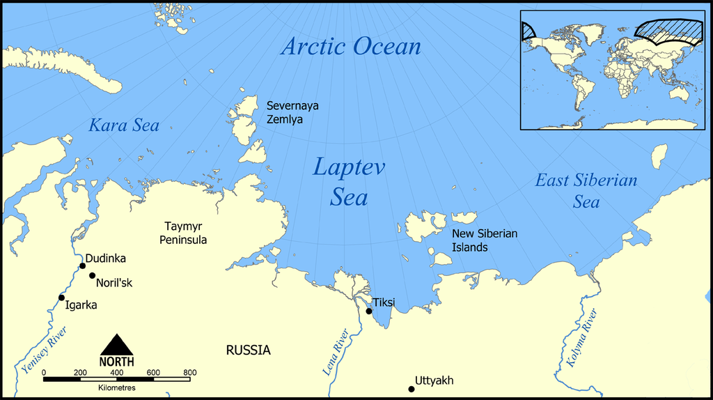
English: Location of the Laptev Sea north of Siberia, Russia. The sea is part of the Arctic Ocean, and neighbours the Kara Sea and East Siberian Sea. |
| Tarehe | |
| Chanzo | Kazi yangu |
| Mwandishi | NormanEinstein |

|
This locator map image could be re-created using vector graphics as an SVG file. This has several advantages; see Commons:Media for cleanup for more information. If an SVG form of this image is available, please upload it and afterwards replace this template with
{{vector version available|new image name}}.
It is recommended to name the SVG file “Laptev Sea map.svg”—then the template Vector version available (or Vva) does not need the new image name parameter. |
Hatimiliki
I, the copyright holder of this work, hereby publish it under the following licenses:

|
Ruhusa inakubalika kunakili, kusambaza na/au kurekebisha chini ya matakwa ya GNU Free Documentation License, Toleo 1.2 au toleo lolote lile la baadaye ambalo litachapishwa na Free Software Foundation; lisilo na Sehemu Tofauti, lisilo na Maandishi-Kava-Kwa-Mbele, na lisilo na Maandishi-Kava-Kwa -Nyuma. Nakala ya hatimiliki inajumlishwa kwenye sehemu ilioitwa GNU Free Documentation License. |
| Faili hii imeidhinishwa chini ya Creative Commons Attribution- Attribution-Share Alike 3.0 Unported leseni. | ||
shiriki sawa – Ukichanganya, kubadilisha, au kujenga juu ya nyenzo, lazima usambaze michango yako chini ya same or compatible license kama ya awali. | ||
| This licensing tag was added to this file as part of the GFDL licensing update. |
Unaweza kuchagua leseni ya chaguo lako.
Derivative works
Derivative works of this file:
- Laptev Sea map - Morze Łaptiewów polish version-pl.png
- Laptev Sea map-sv.png
- Laptev Sea map hr.svg
- Laptev Sea map hu.svg
Historia ya faili
Bonyeza tarehe/saa kuona faili kama ilivyoonekana wakati huo.
| Tarehe/Saa | Picha ndogo | Vipimo | Mtumiaji | Maelezo | |
|---|---|---|---|---|---|
| sasa hivi | 21:23, 27 Februari 2016 | | 1,500 × 841 (382 KB) | Jahoe | Clean up png coding, stripped off large chunks of irrelevant metadata (left behind by adobe editor). Image itself unaltered. |
| 14:10, 23 Machi 2015 |  | 1,500 × 841 (434 KB) | RokerHRO | optipng -o7 -i0 → 25.66% decrease | |
| 21:42, 5 Desemba 2005 |  | 1,500 × 841 (583 KB) | NormanEinstein | This map shows the location of the Laptev Sea north of Siberia, Russia. The sea is part of the Arctic Ocean, and neighbours the Kara Sea and East Siberian Sea. Created by NormanEinstein, December 5, 2005. {{GFDL-self}} Category:Maps of seas |
Matumizi ya faili
Kurasa hizi 3 zimeunganishwa na faili hili:
Matumizi ya faili ulimwenguni
Wiki nyingine hutumia faili hizi:
- Matumizi kwa af.wikipedia.org
- Matumizi kwa ar.wikipedia.org
- Matumizi kwa azb.wikipedia.org
- Matumizi kwa az.wikipedia.org
- Portal:Coğrafiya
- Taymır yarımadası
- İstifadəçi müzakirəsi:Qızılbaş
- İstifadəçi müzakirəsi:Rəşid Nurməmmədov
- Laptevlər dənizi
- Rıbnıy yarımadası
- Vikipediya:Həftənin yaxşı məqaləsi/may 2019
- Vikipediya:Həftənin yaxşı məqaləsi/18. Həftə 2019
- İstifadəçi müzakirəsi:Araz Yaquboglu/Arxiv 10
- İstifadəçi müzakirəsi:Sortilegus/Arxiv 2019
- Matumizi kwa be-tarask.wikipedia.org
- Matumizi kwa bn.wikipedia.org
- Matumizi kwa br.wikipedia.org
- Matumizi kwa bs.wikipedia.org
- Matumizi kwa ca.wikipedia.org
- Matumizi kwa cs.wikipedia.org
- Matumizi kwa cy.wikipedia.org
- Matumizi kwa da.wikipedia.org
- Matumizi kwa de.wikipedia.org
- Matumizi kwa el.wikipedia.org
- Matumizi kwa en.wikipedia.org
- Matumizi kwa en.wiktionary.org
- Matumizi kwa eo.wikipedia.org
- Matumizi kwa eu.wikipedia.org
- Matumizi kwa fa.wikipedia.org
- Matumizi kwa frr.wikipedia.org
- Matumizi kwa fr.wikipedia.org
Tazama matumizi zaidi ya kimataifa ya faili hii.