Faili:Lower Egypt-en.png

Ukubwa wa hakikisho: piseli 600 × 600. Ukubwa zingine: piseli 240 × 240 | piseli 480 × 480 | piseli 994 × 994.
Faili halisi (piseli 994 × 994, saizi ya faili: 188 KB, aina ya MIME: image/png)
| Faili hili linatoka Wikimedia Commons. Maelezo yapo kule kwenye ukurasa wake wa maelezo unaonekana hapo chini.
|
Muhtasari
| Maelezo |
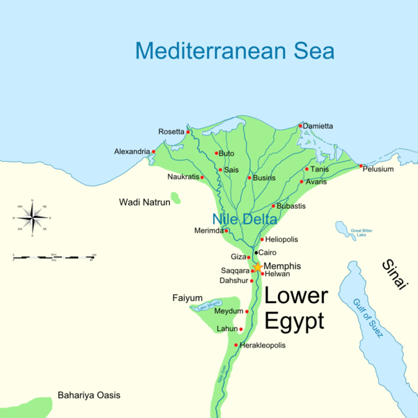
English: Map of Lower Ancient Egypt, showing the Nile and major cities and sites of the Dynastic period (c. 3150 BC to 30 BC). |
| Tarehe | (UTC) |
| Chanzo | |
| Mwandishi |
|
| Matoleo mengine |
Derivative works of this file: |

|
This historical map image could be re-created using vector graphics as an SVG file. This has several advantages; see Commons:Media for cleanup for more information. If an SVG form of this image is available, please upload it and afterwards replace this template with
{{vector version available|new image name}}.
It is recommended to name the SVG file “Lower Egypt-en.svg”—then the template Vector version available (or Vva) does not need the new image name parameter. |
| This is a retouched picture, which means that it has been digitally altered from its original version. Modifications: Cropped image to use as base map. The original can be viewed here: Ancient Egypt map-en.svg:
|
Hatimiliki
I, the copyright holder of this work, hereby publish it under the following licenses:
This file is licensed under the Creative Commons Attribution-Share Alike 3.0 Unported, 2.5 Generic, 2.0 Generic and 1.0 Generic license.
- Uko huru:
- kushiriki – kunakili na kusambaza kazi hiyo
- kwa remix – kurekebisha kazi
- Chini ya masharti yafuatayo:
- sifa – Ni lazima utoe mkopo unaofaa, utoe kiungo cha leseni, na uonyeshe ikiwa mabadiliko yalifanywa. Unaweza kufanya hivyo kwa njia yoyote inayofaa, lakini si kwa njia yoyote inayopendekeza mtoa leseni akuidhinishe wewe au matumizi yako.

|
Ruhusa inakubalika kunakili, kusambaza na/au kurekebisha chini ya matakwa ya GNU Free Documentation License, Toleo 1.2 au toleo lolote lile la baadaye ambalo litachapishwa na Free Software Foundation; lisilo na Sehemu Tofauti, lisilo na Maandishi-Kava-Kwa-Mbele, na lisilo na Maandishi-Kava-Kwa -Nyuma. Nakala ya hatimiliki inajumlishwa kwenye sehemu ilioitwa GNU Free Documentation License. |
Unaweza kuchagua leseni ya chaguo lako.
Kumbukumbu ya upakizaji wa asili
This image is a derivative work of the following images:
- File:Ancient_Egypt_map-en.svg licensed with Cc-by-sa-3.0,2.5,2.0,1.0, GFDL
- 2009-02-20T11:28:29Z Bibi Saint-Pol 1577x3219 (422457 Bytes) fix translation mistake on the windrose
- 2009-01-30T12:13:53Z Bibi Saint-Pol 1577x3219 (422444 Bytes) fix position of Nile Delta
- 2009-01-29T12:21:11Z Bibi Saint-Pol 1577x3219 (422383 Bytes) remove wrong text, adjust frame
- 2009-01-29T12:05:11Z Bibi Saint-Pol 1577x3219 (422757 Bytes) {{Assessments|1=Ancient Egypt map.svg|enwiki=1}} __NOTOC__ == {{int:filedesc}} == {{inkscape}} {{Information |Description= {{en|Map of Ancient Egypt, showing the Nile up to the fifth cataract, and major cities and sites of th
Uploaded with derivativeFX
Historia ya faili
Bonyeza tarehe/saa kuona faili kama ilivyoonekana wakati huo.
| Tarehe/Saa | Picha ndogo | Vipimo | Mtumiaji | Maelezo | |
|---|---|---|---|---|---|
| sasa hivi | 16:30, 14 Februari 2014 | | 994 × 994 (188 KB) | Andy king50 | -border |
| 18:00, 29 Juni 2009 |  | 1,000 × 1,000 (193 KB) | MinisterForBadTimes | Hopefully fixed border this time | |
| 17:59, 29 Juni 2009 |  | 1,000 × 1,000 (193 KB) | MinisterForBadTimes | Moved border | |
| 17:57, 29 Juni 2009 |  | 1,000 × 1,000 (193 KB) | MinisterForBadTimes | Added border | |
| 17:49, 29 Juni 2009 |  | 1,000 × 1,000 (190 KB) | MinisterForBadTimes | {{Information |Description={{en|Map of Lower Ancient Egypt, showing the Nile and major cities and sites of the Dynastic period (c. 3150 BC to 30 BC). |Source=*File:Ancient_Egypt_map-en.svg |Date=2009-06-29 18:49 (UTC) |Author=*[[:File:Ancient_Egypt_ |
Matumizi ya faili
Ukurasa huu umeunganishwa na faili hili:
Matumizi ya faili ulimwenguni
Wiki nyingine hutumia faili hizi:
- Matumizi kwa ar.wikipedia.org
- Matumizi kwa arz.wikipedia.org
- Matumizi kwa az.wikipedia.org
- Matumizi kwa bg.wikipedia.org
- Matumizi kwa br.wikipedia.org
- Matumizi kwa cs.wikipedia.org
- Matumizi kwa de.wikipedia.org
- Matumizi kwa de.wikivoyage.org
- Matumizi kwa el.wikipedia.org
- Matumizi kwa en.wikipedia.org
- Matumizi kwa es.wikipedia.org
- Matumizi kwa et.wikipedia.org
- Matumizi kwa eu.wikipedia.org
- Matumizi kwa fr.wikipedia.org
- Matumizi kwa he.wikipedia.org
- Matumizi kwa hu.wikipedia.org
- Matumizi kwa it.wikipedia.org
- Matumizi kwa ja.wikipedia.org
Tazama matumizi zaidi ya kimataifa ya faili hii.