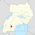
Faili:Lyantonde District in Uganda.svg

Faili halisi(faili la SVG, husemwa kuwa piseli 1,441 × 1,466, saizi ya faili: 366 KB)

Faili hili linatoka Wikimedia Commons. Maelezo yapo kule kwenye ukurasa wake wa maelezo unaonekana hapo chini.
Commons ni mahali mtandaoni pa kuhifadhia jalada na hati za picha na sauti zenye leseni huria. Unaweza kuisadia.

Muhtasari

Description
English: The location of Lyantonde District in Uganda, showing district boundaries as they stood in June 2017. For other districts, see Category:SVG locator maps of Districts in Uganda (location map scheme). This map may be incomplete, and may contain errors. Don't rely solely on it for navigation. In particular, note that this map overlays a spherical pseudo-mercator projection on an equirectangular projection; it is far from technically perfect.
 
This W3C-unspecified vector image was created with Inkscape .
Tarehe
Chanzo

Derivative of:

Muumbaji
OpenStreetMap contributors, Jarry1250, NordNordWest
Ruhusa
(Kutumia faili tena)
w:en:Creative Commons
sifa shiriki sawa
Sifa: © OpenStreetMap contributors, Jarry1250, NordNordWest/Wikipedia
Uko huru:
  • kushiriki – kunakili na kusambaza kazi hiyo
  • kwa remix – kurekebisha kazi
Chini ya masharti yafuatayo:
  • sifa – Ni lazima utoe mkopo unaofaa, utoe kiungo cha leseni, na uonyeshe ikiwa mabadiliko yalifanywa. Unaweza kufanya hivyo kwa njia yoyote inayofaa, lakini si kwa njia yoyote inayopendekeza mtoa leseni akuidhinishe wewe au matumizi yako.
shiriki sawa – Ukichanganya, kubadilisha, au kujenga juu ya nyenzo, lazima usambaze michango yako chini ya same or compatible license kama ya awali.
This work contains information from OpenStreetMap, which is made available under the Open Database License (ODbL).

The ODbL does not require any particular license for maps produced from ODbL data. Prior to 1 August 2020, map tiles produced by the OpenStreetMap Foundation were licensed under the CC-BY-SA-2.0 license. Maps produced by other people may be subject to other licences.

 Geotemporal data
Map location Lyantonde District, Uganda
Spatial reference system equirectangular
Bounding box
N: 4.5°N
W: 29.2°E E: 35.3°E
S: 1.7°S
Georeferencing Georeference the map in Wikimaps Warper If inappropriate please set warp_status = skip to hide.

Captions

Add a one-line explanation of what this file represents

Items portrayed in this file

depicts Kiingereza

copyright status Kiingereza

copyrighted Kiingereza

Historia ya faili

Bonyeza tarehe/saa kuona faili kama ilivyoonekana wakati huo.

Tarehe/SaaPicha ndogoVipimoMtumiajiMaelezo
sasa hivi21:05, 25 Juni 2017Picha ndogo ya toleo la 21:05, 25 Juni 20171,441 × 1,466 (366 KB)Jarry1250pattypan 17.05

Kurasa hizi 2 zimeunganishwa na faili hili:

Matumizi ya faili ulimwenguni

Wiki nyingine hutumia faili hizi:

Data juu