Faili:Map 1914 WWI Alliances.jpg

Faili halisi (piseli 1,682 × 1,328, saizi ya faili: 615 KB, aina ya MIME: image/jpeg)
| Faili hili linatoka Wikimedia Commons. Maelezo yapo kule kwenye ukurasa wake wa maelezo unaonekana hapo chini.
|
Muhtasari
| Maelezo |
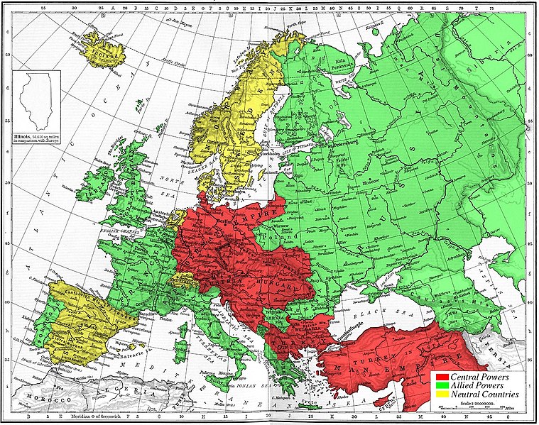
Map of Europe's alliances in 1915. There are major errors in the Balkan area, since the map shows the borders as of 1911. After the Balkan Wars the borders changed significantly.
I, Carnildo, c |
| Tarehe | 6 Novemba 2005 (original upload date) |
| Chanzo | No machine-readable source provided. Own work assumed (based on copyright claims). |
| Mwandishi | No machine-readable author provided. Knutux assumed (based on copyright claims). |
Hatimiliki
| I, the copyright holder of this work, release this work into the public domain. This applies worldwide. Katika nchi zingine hii haiwezekani kisheria; kama ni hivyo: I grant anyone the right to use this work for any purpose, without any conditions, unless such conditions are required by law. |
juntin tirewewLJDBB and his mother (Adolfa Hitler)
Historia ya faili
Bonyeza tarehe/saa kuona faili kama ilivyoonekana wakati huo.
| Tarehe/Saa | Picha ndogo | Vipimo | Mtumiaji | Maelezo | |
|---|---|---|---|---|---|
| sasa hivi | 15:09, 6 Novemba 2005 | | 1,682 × 1,328 (615 KB) | Knutux | Map of Europe's alliances in 1915. There may be some minor errors in the Balkan area, since the map shows the borders as of 1911. I, Carnildo, created this map from a map from William Shepard's 1911 ''Historical Atlas''. The o |
Matumizi ya faili
Kurasa hizi 2 zimeunganishwa na faili hili:
Matumizi ya faili ulimwenguni
Wiki nyingine hutumia faili hizi:
- Matumizi kwa ar.wikipedia.org
- Matumizi kwa ast.wikipedia.org
- Matumizi kwa be.wikipedia.org
- Matumizi kwa bo.wikipedia.org
- Matumizi kwa br.wikipedia.org
- Matumizi kwa ca.wikipedia.org
- Matumizi kwa cs.wikipedia.org
- Matumizi kwa da.wikipedia.org
- Matumizi kwa en.wikipedia.org
- Matumizi kwa en.wikibooks.org
- Matumizi kwa es.wikipedia.org
- Matumizi kwa eu.wikipedia.org
- Matumizi kwa fr.wikipedia.org
- Matumizi kwa gl.wikipedia.org
- Matumizi kwa he.wikipedia.org
- Matumizi kwa ia.wikipedia.org
- Matumizi kwa is.wikipedia.org
- Matumizi kwa it.wikipedia.org
- Matumizi kwa ja.wikipedia.org
- Matumizi kwa nl.wikipedia.org
- Matumizi kwa pt.wikipedia.org
- Matumizi kwa ro.wikipedia.org
- Matumizi kwa sk.wikipedia.org
- Matumizi kwa sl.wikipedia.org
- Matumizi kwa sv.wikipedia.org
- Matumizi kwa tr.wikipedia.org
- Matumizi kwa vi.wikipedia.org
Tazama matumizi zaidi ya kimataifa ya faili hii.