Faili:Map Anatolia ancient regions-en.svg

Faili halisi (faili la SVG, husemwa kuwa piseli 921 × 596, saizi ya faili: 256 KB)
| Faili hili linatoka Wikimedia Commons. Maelezo yapo kule kwenye ukurasa wake wa maelezo unaonekana hapo chini.
|
| Maelezo |
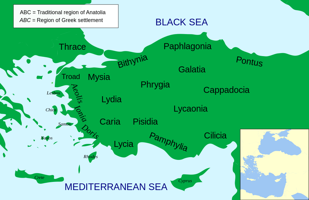
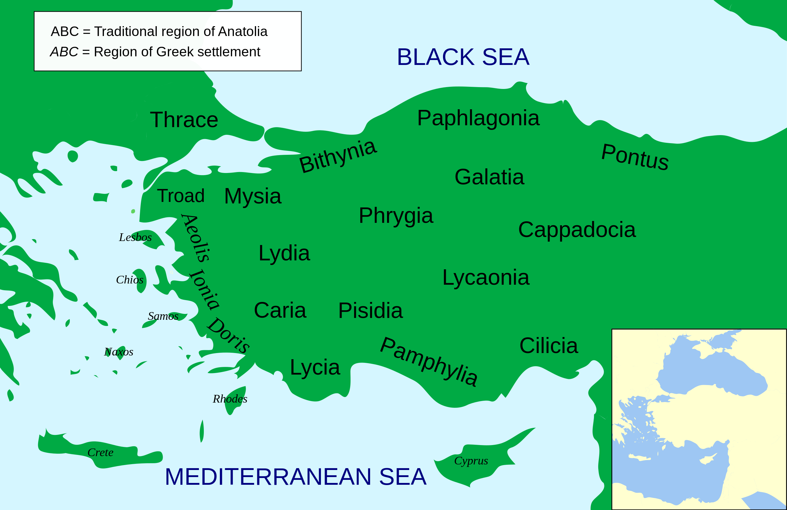
Català: Mapa regional d'Àsia Menor al segle II aC
English: Regional map of Asia Minor in the 2nd Century BC |
| Tarehe | (UTC) |
| Chanzo | |
| Mwandishi |
|
| Matoleo mengine |
Other related versions: []
Derivative works of this file: |


.svg)


|
This SVG file contains embedded text that can be translated into your language, using any capable SVG editor, text editor or the SVG Translate tool. For more information see: About translating SVG files. |
This file is translated using SVG <switch> elements. All translations are stored in the same file! Learn more.
For most Wikipedia projects, you can embed the file normally (without a To translate the text into your language, you can use the SVG Translate tool. Alternatively, you can download the file to your computer, add your translations using whatever software you're familiar with, and re-upload it with the same name. You will find help in Graphics Lab if you're not sure how to do this. |
| This is a retouched picture, which means that it has been digitally altered from its original version. Modifications: Increased legibility, slight corrections in position. The original can be viewed here: Asia Minor Political 500BC.svg:
|
- Uko huru:
- kushiriki – kunakili na kusambaza kazi hiyo
- kwa remix – kurekebisha kazi
- Chini ya masharti yafuatayo:
- sifa – Ni lazima utoe mkopo unaofaa, utoe kiungo cha leseni, na uonyeshe ikiwa mabadiliko yalifanywa. Unaweza kufanya hivyo kwa njia yoyote inayofaa, lakini si kwa njia yoyote inayopendekeza mtoa leseni akuidhinishe wewe au matumizi yako.

|
Ruhusa inakubalika kunakili, kusambaza na/au kurekebisha chini ya matakwa ya GNU Free Documentation License, Toleo 1.2 au toleo lolote lile la baadaye ambalo litachapishwa na Free Software Foundation; lisilo na Sehemu Tofauti, lisilo na Maandishi-Kava-Kwa-Mbele, na lisilo na Maandishi-Kava-Kwa -Nyuma. Nakala ya hatimiliki inajumlishwa kwenye sehemu ilioitwa GNU Free Documentation License. |
Kumbukumbu ya upakizaji wa asili
This image is a derivative work of the following images:
- File:Asia_Minor_Political_500BC.svg licensed with Cc-by-sa-3.0, GFDL
- 2009-04-22T07:38:42Z MinisterForBadTimes 921x596 (283615 Bytes) Coloured in rogue region
- 2009-04-22T07:36:20Z MinisterForBadTimes 921x596 (283353 Bytes) Changed fonts...again
- 2009-04-22T07:33:39Z MinisterForBadTimes 921x596 (283414 Bytes) Changed fonts
- 2009-04-22T07:25:50Z MinisterForBadTimes 921x596 (284262 Bytes) {{Information |Description={{en|1= Political map of Asia Minor in 500 BC}} |Source=*[[:File:Mysia.svg|]] |Date=2009-04-22 08:23 (UTC) |Author=*[[:File:Mysia.svg|]]: [[User:Emok|Emok]] *derivative work: *[[:Image:Mysia_map_anc
Uploaded with derivativeFX
Historia ya faili
Bonyeza tarehe/saa kuona faili kama ilivyoonekana wakati huo.
| Tarehe/Saa | Picha ndogo | Vipimo | Mtumiaji | Maelezo | |
|---|---|---|---|---|---|
| sasa hivi | 14:14, 15 Februari 2024 | | 921 × 596 (256 KB) | Manlleus | File uploaded using svgtranslate tool (https://svgtranslate.toolforge.org/). Added translation for ca. |
| 14:01, 15 Februari 2024 |  | 921 × 596 (235 KB) | Manlleus | fixed text labels for translation | |
| 19:48, 23 Aprili 2009 |  | 921 × 596 (278 KB) | MinisterForBadTimes | Added Galatia, minor other changes | |
| 16:01, 22 Aprili 2009 |  | 921 × 596 (277 KB) | MinisterForBadTimes | {{Information |Description={{en|1= Political map of Asia Minor in 500 BC}} |Source=*File:Asia_Minor_Political_500BC.svg |Date=2009-04-22 17:00 (UTC) |Author=*File:Asia_Minor_Political_500BC.svg: *Mysia.svg: [[User:Emok|Emok |
Matumizi ya faili
Matumizi ya faili ulimwenguni
Wiki nyingine hutumia faili hizi:
- Matumizi kwa af.wikipedia.org
- Matumizi kwa als.wikipedia.org
- Matumizi kwa am.wikipedia.org
- Matumizi kwa ar.wikipedia.org
- Matumizi kwa azb.wikipedia.org
- Matumizi kwa az.wikipedia.org
- Matumizi kwa be-tarask.wikipedia.org
- Matumizi kwa bg.wikipedia.org
- Matumizi kwa bn.wikipedia.org
- Matumizi kwa br.wikipedia.org
- Matumizi kwa bs.wikipedia.org
- Matumizi kwa ca.wikipedia.org
- Matumizi kwa cs.wikipedia.org
- Matumizi kwa da.wikipedia.org
- Matumizi kwa de.wikipedia.org
- Matumizi kwa diq.wikipedia.org
- Matumizi kwa en.wikipedia.org
Tazama matumizi zaidi ya kimataifa ya faili hii.