Faili:Map of Quebec.png

Ukubwa wa hakikisho: piseli 569 × 600. Ukubwa zingine: piseli 228 × 240 | piseli 455 × 480.
Faili halisi (piseli 800 × 843, saizi ya faili: 316 KB, aina ya MIME: image/png)
| Faili hili linatoka Wikimedia Commons. Maelezo yapo kule kwenye ukurasa wake wa maelezo unaonekana hapo chini.
|
| Maelezo |
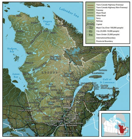
English: Map of Québec
Français : Carte du Québec |
||
| Tarehe | |||
| Chanzo | en:Image:Map of Quebec (English).png created by John Fowler (cartographer), who released the image to the public domain. Geospatial data from: The Atlas of Canada, The National Atlas of the United States and U.S. Geological Survey. | ||
| Mwandishi | John Fowler / Upload by Leslie | ||
| Ruhusa (Kutumia faili tena) |
|
||
| Matoleo mengine |
Français : Version française Image:Map of Quebec-fr.png
English: French version Image:Map of Quebec-fr.png |
.png)
Historia ya faili
Bonyeza tarehe/saa kuona faili kama ilivyoonekana wakati huo.
| Tarehe/Saa | Picha ndogo | Vipimo | Mtumiaji | Maelezo | |
|---|---|---|---|---|---|
| sasa hivi | 09:22, 26 Februari 2006 | | 800 × 843 (316 KB) | Leslie | {{PD}} Created by John Fowler, who released the image to the public domain. en:Image:Map of Quebec (English).png Category:Québec |
Matumizi ya faili
Hakuna kurasa zozote zinazotumia faili hii.
Matumizi ya faili ulimwenguni
Wiki nyingine hutumia faili hizi:
- Matumizi kwa en.wikipedia.org
- Matumizi kwa et.wikipedia.org
- Matumizi kwa fi.wikipedia.org
- Matumizi kwa he.wikipedia.org
- Matumizi kwa it.wikipedia.org
- Matumizi kwa mk.wikipedia.org
- Matumizi kwa nl.wikipedia.org
- Matumizi kwa no.wikipedia.org
- Matumizi kwa zh.wikipedia.org