Faili:Saint-Martin Island topographic map-en.svg

Size of this PNG preview of this SVG file: piseli 795 × 599. Ukubwa zingine: piseli 319 × 240 | piseli 637 × 480 | piseli 1,019 × 768 | piseli 1,280 × 965 | piseli 2,560 × 1,930 | piseli 2,600 × 1,960.
Faili halisi (faili la SVG, husemwa kuwa piseli 2,600 × 1,960, saizi ya faili: 1.57 MB)
| Faili hili linatoka Wikimedia Commons. Maelezo yapo kule kwenye ukurasa wake wa maelezo unaonekana hapo chini.
|
Muhtasari
| Camera location | | View this and other nearby images on: OpenStreetMap |
|---|
| Maelezo |
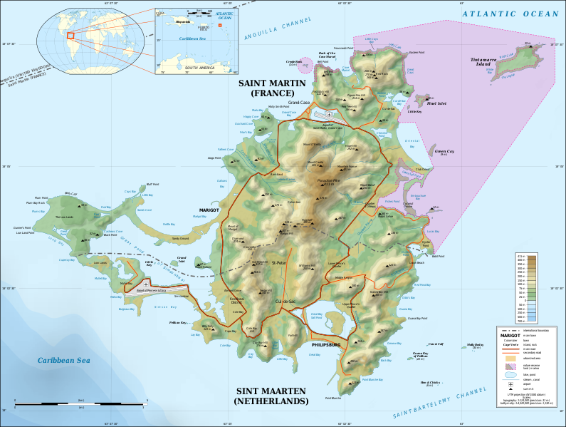
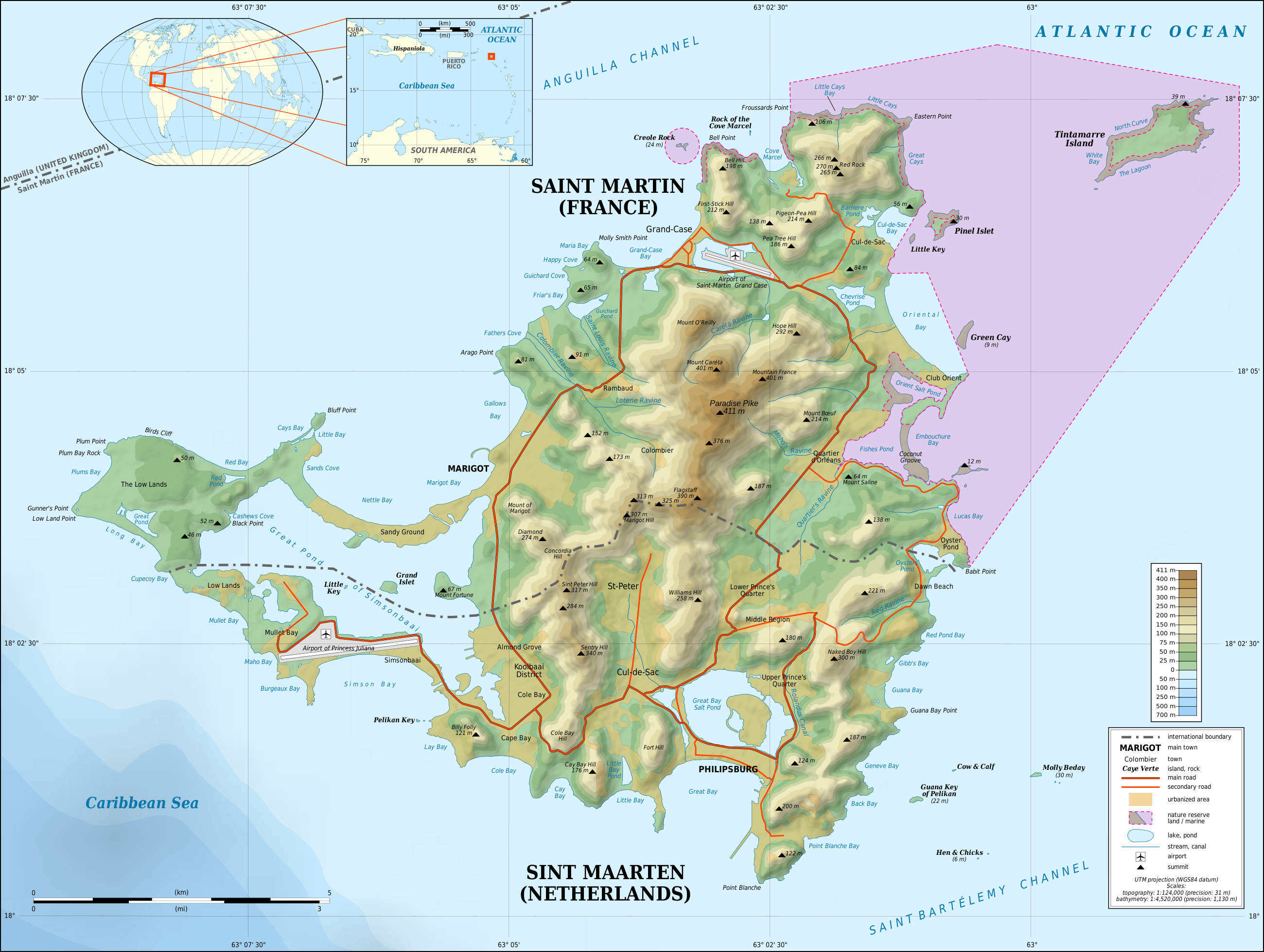
English: Topographic map in English of the Caribbean island of Saint-Martin / Sint Maarten, divided between French and Dutch halves.
Note: the shaded relief is a raster image embedded in the SVG file. Français : Carte topographique en anglais de l'île de Saint-Martin / Sint Maarten dans les Antilles, divisée en une partie française et une partie néerlandaise. Note : les ombres du relief sont une image bitmap embarquée dans le fichier SVG.
|
||
| Tarehe | 2009-05, updated 2015-10 | ||
| Chanzo |
Own work
|
||
| Mwandishi | Eric Gaba (Sting - fr:Sting) | ||
| Ruhusa (Kutumia faili tena) |
|
||
| Matoleo mengine |
[]
Same base map but smaller and without topography:
|


|
This SVG file contains embedded text that can be translated into your language, using any capable SVG editor, text editor or the SVG Translate tool. For more information see: About translating SVG files. |
Hatimiliki
I, the copyright holder of this work, hereby publish it under the following licenses:
Faili hii imeidhinishwa chini ya Creative Commons Attribution- Attribution-Share Alike 3.0 Unported leseni.
- Uko huru:
- kushiriki – kunakili na kusambaza kazi hiyo
- kwa remix – kurekebisha kazi
- Chini ya masharti yafuatayo:
- sifa – Ni lazima utoe mkopo unaofaa, utoe kiungo cha leseni, na uonyeshe ikiwa mabadiliko yalifanywa. Unaweza kufanya hivyo kwa njia yoyote inayofaa, lakini si kwa njia yoyote inayopendekeza mtoa leseni akuidhinishe wewe au matumizi yako.

|
Ruhusa inakubalika kunakili, kusambaza na/au kurekebisha chini ya matakwa ya GNU Free Documentation License, Toleo 1.2 au toleo lolote lile la baadaye ambalo litachapishwa na Free Software Foundation; lisilo na Sehemu Tofauti, lisilo na Maandishi-Kava-Kwa-Mbele, na lisilo na Maandishi-Kava-Kwa -Nyuma. Nakala ya hatimiliki inajumlishwa kwenye sehemu ilioitwa GNU Free Documentation License. |
Unaweza kuchagua leseni ya chaguo lako.
Historia ya faili
Bonyeza tarehe/saa kuona faili kama ilivyoonekana wakati huo.
| Tarehe/Saa | Picha ndogo | Vipimo | Mtumiaji | Maelezo | |
|---|---|---|---|---|---|
| sasa hivi | 22:55, 17 Oktoba 2015 | | 2,600 × 1,960 (1.57 MB) | Sting | Using NASA SRTM 1 topographic data ; now only the shaded relief is raster |
| 20:39, 5 Mei 2009 |  | 2,600 × 1,960 (1.45 MB) | Sting | == Summary == {{Location|18|04|00|N|63|03|30|W|scale:100000}} <br/> {{Information |Description={{en|Topographic map in English of the Caribbean island of Saint-Martin / Sint Maarten, divided between French and Dutch halves.<br/> ''Not |
Matumizi ya faili
Ukurasa huu umeunganishwa na faili hili:
Matumizi ya faili ulimwenguni
Wiki nyingine hutumia faili hizi:
- Matumizi kwa ar.wikipedia.org
- Matumizi kwa bn.wikipedia.org
- Matumizi kwa bs.wikipedia.org
- Matumizi kwa el.wikipedia.org
- Matumizi kwa en.wikipedia.org
- Matumizi kwa eo.wikipedia.org
- Matumizi kwa es.wikipedia.org
- Matumizi kwa es.wikivoyage.org
- Matumizi kwa fa.wikipedia.org
- Matumizi kwa gl.wikipedia.org
- Matumizi kwa hr.wikipedia.org
- Matumizi kwa hu.wikipedia.org
- Matumizi kwa ia.wikipedia.org
- Matumizi kwa id.wikipedia.org
- Matumizi kwa is.wikipedia.org
- Matumizi kwa it.wikipedia.org
- Matumizi kwa ka.wikipedia.org
- Matumizi kwa nl.wikipedia.org
- Matumizi kwa pt.wikipedia.org
- Matumizi kwa ru.wikipedia.org
- Matumizi kwa sl.wikipedia.org
- Matumizi kwa sr.wikipedia.org
- Matumizi kwa su.wikipedia.org
- Matumizi kwa ta.wikipedia.org
- Matumizi kwa uk.wikipedia.org
- Matumizi kwa xmf.wikipedia.org
- Matumizi kwa zea.wikipedia.org
- Matumizi kwa zh.wikipedia.org