Faili:Sogn og Fjordane Municipalities.png
Ukubwa wa hakikisho: piseli 800 × 487. Ukubwa zingine: piseli 320 × 195 | piseli 640 × 390 | piseli 1,025 × 624.
Faili halisi (piseli 1,025 × 624, saizi ya faili: 29 KB, aina ya MIME: image/png)
| Faili hili linatoka Wikimedia Commons. Maelezo yapo kule kwenye ukurasa wake wa maelezo unaonekana hapo chini.
|

|
This locator map image could be re-created using vector graphics as an SVG file. This has several advantages; see Commons:Media for cleanup for more information. If an SVG form of this image is available, please upload it and afterwards replace this template with
{{vector version available|new image name}}.
It is recommended to name the SVG file “Sogn og Fjordane Municipalities.svg”—then the template Vector version available (or Vva) does not need the new image name parameter. |
Transferred from en.wikipedia to Commons by Maksim.
The original description page was here. All following user names refer to en.wikipedia.
Muhtasari
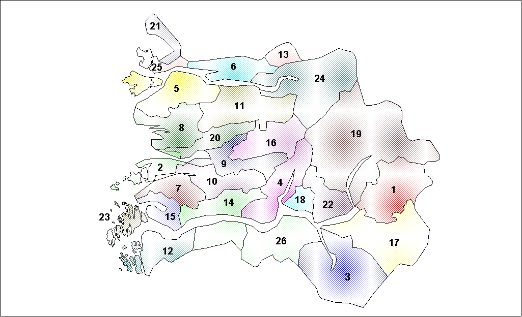
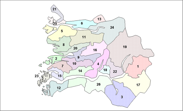
Map of the municipalities of Sogn og Fjordane County in Norway. Created by Rarelibra for public domain use. Created using MapInfo Professional v7.5 and various mapping resources.
Hatimiliki
| I, the copyright holder of this work, release this work into the public domain. This applies worldwide. Katika nchi zingine hii haiwezekani kisheria; kama ni hivyo: I grant anyone the right to use this work for any purpose, without any conditions, unless such conditions are required by law. |
| date/time | username | edit summary |
|---|---|---|
| 14:58, 26 January 2006 | en:User:Rarelibra | (Map of the municipalities of Sogn og Fjordane County in Norway. Created by <a href="/wiki/User:Rarelibra" title="User:Rarelibra">Rarelibra</a> for public domain use. Created using MapInfo Professional v7.5 and various mapping resources.) |
Kumbukumbu ya upakizaji wa asili
Legend: (cur) = this is the current file, (del) = delete this old version, (rev) = revert to this old version.
Click on date to download the file or see the image uploaded on that date.
- (del) (cur) 18:36, 26 January 2006 . . en:User:Rarelibra Rarelibra ( en:User_talk:Rarelibra Talk) . . 1025x624 (30045 bytes) (Map of the municipalities of Sogn og Fjordane County in Norway. Created by en:User:Rarelibra Rarelibra for public domain use. Created using MapInfo Professional v7.5 and various mapping resources.)
- (del) (rev) 14:58, 26 January 2006 . . en:User:Rarelibra Rarelibra ( en:User_talk:Rarelibra Talk) . . 1025x624 (30510 bytes) (Map of the municipalities of Sogn og Fjordane County in Norway. Created by en:User:Rarelibra Rarelibra for public domain use. Created using MapInfo Professional v7.5 and various mapping resources.)
Historia ya faili
Bonyeza tarehe/saa kuona faili kama ilivyoonekana wakati huo.
| Tarehe/Saa | Picha ndogo | Vipimo | Mtumiaji | Maelezo | |
|---|---|---|---|---|---|
| sasa hivi | 08:57, 26 Machi 2006 | | 1,025 × 624 (29 KB) | Maksim | La bildo estas kopiita de wikipedia:en. La originala priskribo estas: == Summary == Map of the municipalities of Sogn og Fjordane County in Norway. Created by Rarelibra for public domain use. Created using MapInfo Professional v7.5 and |
Matumizi ya faili
Ukurasa huu umeunganishwa na faili hili:
Matumizi ya faili ulimwenguni
Wiki nyingine hutumia faili hizi:
- Matumizi kwa bat-smg.wikipedia.org
- Matumizi kwa en.wikipedia.org
- Matumizi kwa eo.wikipedia.org
- Matumizi kwa es.wikipedia.org
- Matumizi kwa et.wikipedia.org
- Matumizi kwa eu.wikipedia.org
- Matumizi kwa hr.wikipedia.org
- Matumizi kwa hu.wikipedia.org
- Matumizi kwa id.wikipedia.org
- Matumizi kwa ja.wikipedia.org
- Matumizi kwa ka.wikipedia.org
- Matumizi kwa ko.wikipedia.org
- Matumizi kwa lt.wikipedia.org
- Matumizi kwa nl.wikipedia.org
- Matumizi kwa pt.wikipedia.org
- Matumizi kwa ru.wikipedia.org
- Matumizi kwa sr.wikipedia.org
- Matumizi kwa uk.wikipedia.org
- Matumizi kwa vi.wikipedia.org
- Matumizi kwa zea.wikipedia.org
- Matumizi kwa zh.wikipedia.org