Faili:Star Trail above Beccles - geograph.org.uk - 1855505.jpg
Hakuna saizi kubwa zaidi.
Star_Trail_above_Beccles_-_geograph.org.uk_-_1855505.jpg (piseli 800 × 496, saizi ya faili: 100 KB, aina ya MIME: image/jpeg)
| Faili hili linatoka Wikimedia Commons. Maelezo yapo kule kwenye ukurasa wake wa maelezo unaonekana hapo chini.
|
Muhtasari
| Maelezo |
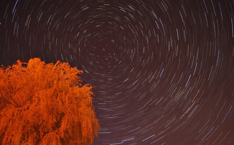
English: Star Trail above Beccles, near to Gillingham, Norfolk, Great Britain.
My last trail (image) was taken in an area with large skies and less light pollution. However I decided to venture out for a little while at Beccles Quay near to midnight and try a star trail here. The street lights highlighted the tree to make it look as if it were dead! However, I can inform you it is green and alive in real life TM4291 : Beccles Quay. I had learnt from last time and brought a stopwatch, meaning even pictures of the same quailty. Twenty photos one and a half minutes long stitched together to give this effect. The faint streak above Polaris (the centre star) is a plane, sadly not a meteor. |
| Tarehe | |
| Chanzo | From geograph.org.uk; transferred by User:Rubberstamp using geograph_org2commons. |
| Mwandishi | Ashley Dace |
| Ruhusa (Kutumia faili tena) |
Creative Commons Attribution Share-alike license 2.0 |
| Camera location | | View this and other nearby images on: OpenStreetMap |
|---|
| Object location | | View this and other nearby images on: OpenStreetMap |
|---|
_region:GB-GBN_heading:337.00&language=sw)
Hatimiliki

|
This image was taken from the Geograph project collection. See this photograph's page on the Geograph website for the photographer's contact details. The copyright on this image is owned by Ashley Dace and is licensed for reuse under the Creative Commons Attribution-ShareAlike 2.0 license.
|
This file is licensed under the Creative Commons Attribution-Share Alike 2.0 Generic license.
Sifa: Ashley Dace
- Uko huru:
- kushiriki – kunakili na kusambaza kazi hiyo
- kwa remix – kurekebisha kazi
- Chini ya masharti yafuatayo:
- sifa – Ni lazima utoe mkopo unaofaa, utoe kiungo cha leseni, na uonyeshe ikiwa mabadiliko yalifanywa. Unaweza kufanya hivyo kwa njia yoyote inayofaa, lakini si kwa njia yoyote inayopendekeza mtoa leseni akuidhinishe wewe au matumizi yako.
Historia ya faili
Bonyeza tarehe/saa kuona faili kama ilivyoonekana wakati huo.
| Tarehe/Saa | Picha ndogo | Vipimo | Mtumiaji | Maelezo | |
|---|---|---|---|---|---|
| sasa hivi | 14:36, 27 Julai 2010 | | 800 × 496 (100 KB) | File Upload Bot (Magnus Manske) | == {{int:filedesc}} == {{Information |Description={{en|1=Star Trail above Beccles, near to Gillingham, Norfolk, Great Britain. My last trail (<span class="nowrap"><a title="http://www.geograph.org.uk/photo/1852095)" rel="nofollow" href="http://www.geograp |
Matumizi ya faili
Ukurasa huu umeunganishwa na faili hili:
Matumizi ya faili ulimwenguni
Wiki nyingine hutumia faili hizi:
- Matumizi kwa af.wikipedia.org
- Matumizi kwa bh.wikipedia.org
- Matumizi kwa ce.wikipedia.org
- Matumizi kwa cs.wikipedia.org
- Matumizi kwa en.wikipedia.org
- Matumizi kwa en.wikibooks.org
- Matumizi kwa eu.wikipedia.org
- Matumizi kwa fa.wikipedia.org
- Matumizi kwa hi.wikipedia.org
- Matumizi kwa is.wikipedia.org
- Matumizi kwa ka.wikipedia.org
- Matumizi kwa kk.wikipedia.org
- Matumizi kwa ko.wikipedia.org
- Matumizi kwa mn.wikipedia.org
- Matumizi kwa ms.wikipedia.org
- Matumizi kwa nl.wiktionary.org
- Matumizi kwa pl.wikipedia.org
- Matumizi kwa ru.wikipedia.org
- Matumizi kwa sd.wikipedia.org
- Matumizi kwa sq.wikipedia.org
- Matumizi kwa sr.wikipedia.org
- Matumizi kwa uk.wikipedia.org
- Matumizi kwa vi.wikipedia.org