Faili:Vegetation.png

Ukubwa wa hakikisho: piseli 800 × 359. Ukubwa zingine: piseli 320 × 144 | piseli 640 × 287 | piseli 1,385 × 622.
Faili halisi (piseli 1,385 × 622, saizi ya faili: 85 KB, aina ya MIME: image/png)
| Faili hili linatoka Wikimedia Commons. Maelezo yapo kule kwenye ukurasa wake wa maelezo unaonekana hapo chini.
|
Muhtasari
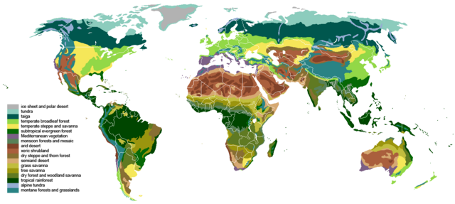
| Maelezo | The main biomes in the world. Drawn by hand using maps. |
| Tarehe | |
| Chanzo |
The blank world map in Commons and WSOY Iso karttakirja for the information. Referred to over a hundred sources, but here are some of the more extensively used ones: [1], [2], [3], [4], [5], [6], [7], [8], [9], [10] |
| Mwandishi | Ville Koistinen (user Vzb83) |
| Matoleo mengine |
Derivative works of this file: |
![[5]](https://www.surfaceview.co.uk/storage/image/VMA0018.jpg)
![[6]](https://upload.wikimedia.org/wikipedia/commons/4/4f/Vegetationszonen.png)
![[7]](https://esdac.jrc.ec.europa.eu/images/Eudasm/Africa/images/maps/download/afr_veg.jpg)
![[8]](https://www.researchgate.net/profile/Julie-Morin-9/publication/319979374/figure/fig2/AS:614404802478081@1523496928789/UNESCO-AETFAT-UNSO-Whites-vegetation-map-of-Africa-The-Guineo-Congolian-regional.png)
![[9]](https://www.researchgate.net/profile/Andrea-Kay/publication/276452894/figure/fig1/AS:623557285523457@1525679050775/Map-of-study-area-showing-modern-potential-natural-vegetation-simplified-from-White.png)
![[10]](https://i.pinimg.com/originals/5d/b3/b5/5db3b5b71e47b5467d8df815cd525df5.png)

|
This biogeographical map image could be re-created using vector graphics as an SVG file. This has several advantages; see Commons:Media for cleanup for more information. If an SVG form of this image is available, please upload it and afterwards replace this template with
{{vector version available|new image name}}.
It is recommended to name the SVG file “Vegetation.svg”—then the template Vector version available (or Vva) does not need the new image name parameter. |
Hatimiliki
I, the copyright holder of this work, hereby publish it under the following licenses:

|
Ruhusa inakubalika kunakili, kusambaza na/au kurekebisha chini ya matakwa ya GNU Free Documentation License, Toleo 1.2 au toleo lolote lile la baadaye ambalo litachapishwa na Free Software Foundation; lisilo na Sehemu Tofauti, lisilo na Maandishi-Kava-Kwa-Mbele, na lisilo na Maandishi-Kava-Kwa -Nyuma. Nakala ya hatimiliki inajumlishwa kwenye sehemu ilioitwa GNU Free Documentation License. |
| Faili hii imeidhinishwa chini ya Creative Commons Attribution- Attribution-Share Alike 3.0 Unported leseni. | ||
shiriki sawa – Ukichanganya, kubadilisha, au kujenga juu ya nyenzo, lazima usambaze michango yako chini ya same or compatible license kama ya awali. | ||
| This licensing tag was added to this file as part of the GFDL licensing update. |
This file is licensed under the Creative Commons Attribution-Share Alike 2.5 Generic, 2.0 Generic and 1.0 Generic license.
- Uko huru:
- kushiriki – kunakili na kusambaza kazi hiyo
- kwa remix – kurekebisha kazi
- Chini ya masharti yafuatayo:
- sifa – Ni lazima utoe mkopo unaofaa, utoe kiungo cha leseni, na uonyeshe ikiwa mabadiliko yalifanywa. Unaweza kufanya hivyo kwa njia yoyote inayofaa, lakini si kwa njia yoyote inayopendekeza mtoa leseni akuidhinishe wewe au matumizi yako.
Unaweza kuchagua leseni ya chaguo lako.
Historia ya faili
Bonyeza tarehe/saa kuona faili kama ilivyoonekana wakati huo.
| Tarehe/Saa | Picha ndogo | Vipimo | Mtumiaji | Maelezo | |
|---|---|---|---|---|---|
| sasa hivi | 18:55, 24 Machi 2024 | | 1,385 × 622 (85 KB) | Berkserker | Added more level of detail, particularly to montane and arid regions. Corrections to savannas. |
| 21:44, 18 Septemba 2023 |  | 1,385 × 622 (81 KB) | Berkserker | Minor correction to key | |
| 21:01, 18 Septemba 2023 |  | 1,385 × 622 (80 KB) | Berkserker | Slight correction to Eastern Australia | |
| 09:37, 11 Agosti 2020 |  | 1,385 × 622 (80 KB) | Berkserker | Corrections to Madagascar | |
| 18:35, 6 Agosti 2020 |  | 1,385 × 622 (80 KB) | Berkserker | Minor optimization according to Dyer 2006 | |
| 07:01, 5 Agosti 2020 |  | 1,385 × 622 (80 KB) | Berkserker | Added a third source: Dyer 2006, specifically to address the issues in Eastern USA | |
| 03:40, 15 Juni 2020 |  | 1,385 × 622 (80 KB) | Berkserker | More corrections as well as fixing remaining dead pixels | |
| 13:22, 9 Juni 2020 |  | 1,385 × 622 (80 KB) | Berkserker | Further corrections based on the same sources | |
| 07:20, 21 Machi 2020 |  | 1,385 × 622 (80 KB) | Berkserker | Minor correction to Andean montane forests | |
| 07:09, 21 Machi 2020 |  | 1,385 × 622 (80 KB) | Berkserker | Fixed key and map colors not matching |
Matumizi ya faili
Hakuna kurasa zozote zinazotumia faili hii.
Matumizi ya faili ulimwenguni
Wiki nyingine hutumia faili hizi:
- Matumizi kwa bh.wikipedia.org
- Matumizi kwa bn.wikipedia.org
- Matumizi kwa bs.wikipedia.org
- Matumizi kwa ckb.wikipedia.org
- Matumizi kwa cs.wikipedia.org
- Matumizi kwa el.wikipedia.org
- Matumizi kwa en.wikipedia.org
- Matumizi kwa en.wikibooks.org
- Matumizi kwa et.wikipedia.org
- Matumizi kwa eu.wikipedia.org
- Matumizi kwa fa.wikipedia.org
- Matumizi kwa fr.wikipedia.org
- Matumizi kwa hi.wikibooks.org
- Matumizi kwa ik.wikipedia.org
- Matumizi kwa ku.wikipedia.org
- Matumizi kwa mk.wikipedia.org
- Matumizi kwa mt.wikipedia.org
- Matumizi kwa no.wikipedia.org
- Matumizi kwa oc.wikipedia.org
- Matumizi kwa om.wikipedia.org
- Matumizi kwa pnb.wikipedia.org
- Matumizi kwa ps.wikipedia.org
- Matumizi kwa pt.wikipedia.org
- Matumizi kwa si.wikipedia.org
- Matumizi kwa ta.wikipedia.org
- Matumizi kwa th.wikipedia.org
- Matumizi kwa tr.wikipedia.org
- Matumizi kwa ur.wikipedia.org
- Matumizi kwa vi.wikipedia.org
- Matumizi kwa vls.wikipedia.org
- Matumizi kwa war.wikipedia.org
- Matumizi kwa www.wikidata.org
- Matumizi kwa zh-yue.wikipedia.org
- Matumizi kwa zh.wikipedia.org