Faili:Wfm shetland map.png

Ukubwa wa hakikisho: piseli 457 × 600. Ukubwa zingine: piseli 183 × 240 | piseli 366 × 480 | piseli 585 × 768 | piseli 780 × 1,024 | piseli 2,000 × 2,624.
Faili halisi (piseli 2,000 × 2,624, saizi ya faili: 784 KB, aina ya MIME: image/png)
| Faili hili linatoka Wikimedia Commons. Maelezo yapo kule kwenye ukurasa wake wa maelezo unaonekana hapo chini.
|
Muhtasari
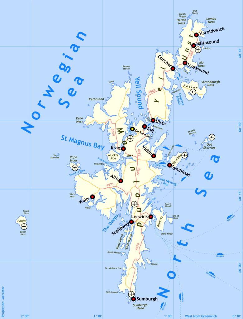
| Maelezo | Shetland map | |||
| Tarehe | ||||
| Chanzo | self-made, details of process below | |||
| Mwandishi | Finlay McWalter | |||
| Ruhusa (Kutumia faili tena) |
I'm Finlay McWalter, and I endorse this message | |||
| Matoleo mengine |
|


Method of production
Drawn by Finlay McWalter in the following manner:
- An outline was rendered using Panmap running public domain NOAA WVS (world vector shoreline).
- This was exported (as a bitmap, all that Panmap can do) to Paint Shop Pro. This was manually repaired (holes filled, island groups tweaked, and shoreline details clarified or erased). Then the bitmap was floodfilled, so that the subsequent vectoriser will produce polygons rather than lines.
- This was imported into Inkscape and vectorised using Inkscape's "path->trace bitmap" function.
- All details were then manually drawn.
- To produce the final PNG, the whole drawing was exported from Inkscape as a PNG. This was then cropped in Photoshop.
Version history
- (July 14th 2005) Initial test version
- (August 29th 2005) Added towns, airports, oil terminal. Muckle Roe now correctly rendered as a separate island.
- (August 29th 2005) Swapped locations of Sumburgh town and Sumburgh Airport, PNGcrushed image.
Hatimiliki
I, the copyright holder of this work, hereby publish it under the following licenses:

|
Ruhusa inakubalika kunakili, kusambaza na/au kurekebisha chini ya matakwa ya GNU Free Documentation License, Toleo 1.2 au toleo lolote lile la baadaye ambalo litachapishwa na Free Software Foundation; lisilo na Sehemu Tofauti, lisilo na Maandishi-Kava-Kwa-Mbele, na lisilo na Maandishi-Kava-Kwa -Nyuma. Nakala ya hatimiliki inajumlishwa kwenye sehemu ilioitwa GNU Free Documentation License. |
| Faili hii imeidhinishwa chini ya Creative Commons Attribution- Attribution-Share Alike 3.0 Unported leseni. | ||
shiriki sawa – Ukichanganya, kubadilisha, au kujenga juu ya nyenzo, lazima usambaze michango yako chini ya same or compatible license kama ya awali. | ||
| This licensing tag was added to this file as part of the GFDL licensing update. |
Unaweza kuchagua leseni ya chaguo lako.
Historia ya faili
Bonyeza tarehe/saa kuona faili kama ilivyoonekana wakati huo.
| Tarehe/Saa | Picha ndogo | Vipimo | Mtumiaji | Maelezo | |
|---|---|---|---|---|---|
| sasa hivi | 19:18, 29 Agosti 2005 | | 2,000 × 2,624 (784 KB) | Finlay McWalter | Swapped locations of Sumburgh town and Sumburgh Airport, PNGcrushed image |
| 18:23, 29 Agosti 2005 |  | 2,019 × 2,659 (1.13 MB) | Finlay McWalter | {{Information| |Description = en:Shetland map |Source = self-made, details of process below |Date = 29th August 2005 |Author = Finlay McWalter |Permission = I'm Finlay McWalter, and I endorse this message |other_version |
Matumizi ya faili
Hakuna kurasa zozote zinazotumia faili hii.
Matumizi ya faili ulimwenguni
Wiki nyingine hutumia faili hizi:
- Matumizi kwa en.wikipedia.org