Faili:20170805 Bolivia 1214 Sucre sRGB (26204168039).jpg

Faili halisi (piseli 3,648 × 2,736, saizi ya faili: 2.16 MB, aina ya MIME: image/jpeg)
| Faili hili linatoka Wikimedia Commons. Maelezo yapo kule kwenye ukurasa wake wa maelezo unaonekana hapo chini.
|
.jpg)
Muhtasari
| Maelezo |
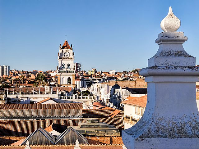
The roof of the Convent of St. Felipe Neri (built in the 17th century and now a museum) provides a panoramic view of the rooftops of Sucre. The tower with the clock in the distance is the bell tower for the Metropolitan Cathedral of Sucre (built between 1559 and 1712 with the clock brought over from London in 1722). Sucre is known as “The White City” because most of the buildings are painted white—and usually have a roof of terracotta tiles. Sucre (elev. 2,810m/9,214ft) was founded by the Spanish in 1538 as Ciudad de la Plata de la Nueva Toledo (Silver City of New Toledo). It became the judicial, religious, and cultural center of the region. Bolivia achieved independence from Spain on 6 August 1825, the last country in Latin America to do so. In 1839 the city was declared the capital of Bolivia and renamed in honor of Antonio José de Sucre (1795-1830), a leader of the fight for independence who was a close friend of Simón Bolívar and served as the second president of Bolivia from the end of 1825 to 1828. (The administrative capital of Bolivia shifted to La Paz in 1898.) The Historic City of Sucre was declared a UNESCO World Heritage Site in 1991. On Google Earth: Convento de San Felipe Neri 19° 3'0.53"S, 65°15'39.91"W Catedral Metropolitana 19° 2'55.48"S, 65°15'35.81"W |
| Tarehe | |
| Chanzo | 20170805_Bolivia_1214 Sucre sRGB |
| Mwandishi | Dan Lundberg |
| Camera location | | View this and other nearby images on: OpenStreetMap |
|---|
.jpg¶ms=-19.049284_N_-065.260462_E_globe:Earth_type:camera_source:Flickr_&language=sw)
Hatimiliki
- Uko huru:
- kushiriki – kunakili na kusambaza kazi hiyo
- kwa remix – kurekebisha kazi
- Chini ya masharti yafuatayo:
- sifa – Ni lazima utoe mkopo unaofaa, utoe kiungo cha leseni, na uonyeshe ikiwa mabadiliko yalifanywa. Unaweza kufanya hivyo kwa njia yoyote inayofaa, lakini si kwa njia yoyote inayopendekeza mtoa leseni akuidhinishe wewe au matumizi yako.
| This image was originally posted to Flickr by Dan Lundberg at https://flickr.com/photos/9508280@N07/26204168039 (archive). It was reviewed on 2 Novemba 2017 by FlickreviewR 2 and was confirmed to be licensed under the terms of the cc-by-sa-2.0. |
Historia ya faili
Bonyeza tarehe/saa kuona faili kama ilivyoonekana wakati huo.
| Tarehe/Saa | Picha ndogo | Vipimo | Mtumiaji | Maelezo | |
|---|---|---|---|---|---|
| sasa hivi | 15:58, 2 Novemba 2017 | | 3,648 × 2,736 (2.16 MB) | Ser Amantio di Nicolao | Transferred from Flickr via Flickr2Commons |
Matumizi ya faili
Ukurasa huu umeunganishwa na faili hili:
Matumizi ya faili ulimwenguni
Wiki nyingine hutumia faili hizi:
- Matumizi kwa ar.wikipedia.org
- Matumizi kwa ca.wikipedia.org
- Matumizi kwa en.wikipedia.org
- Matumizi kwa es.wikipedia.org
- Matumizi kwa mk.wikipedia.org
- Matumizi kwa ml.wikipedia.org
- Matumizi kwa ru.wikipedia.org
- Matumizi kwa vi.wikipedia.org
.jpg)