Faili:Adriatic Sea map.png
Ukubwa wa hakikisho: piseli 422 × 599. Ukubwa zingine: piseli 169 × 240 | piseli 338 × 480 | piseli 704 × 999.
Faili halisi (piseli 704 × 999, saizi ya faili: 235 KB, aina ya MIME: image/png)
| Faili hili linatoka Wikimedia Commons. Maelezo yapo kule kwenye ukurasa wake wa maelezo unaonekana hapo chini.
|

|
This locator map image could be re-created using vector graphics as an SVG file. This has several advantages; see Commons:Media for cleanup for more information. If an SVG form of this image is available, please upload it and afterwards replace this template with
{{vector version available|new image name}}.
It is recommended to name the SVG file “Adriatic Sea map.svg”—then the template Vector version available (or Vva) does not need the new image name parameter. |
Muhtasari
| Maelezo |
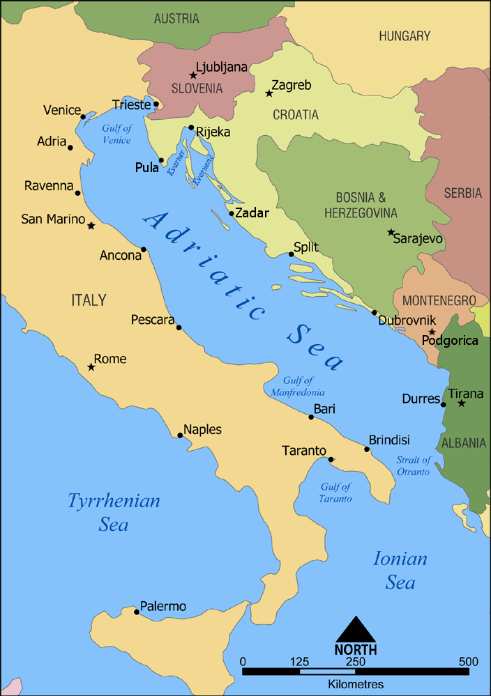
English: A map showing the location of the Adriatic Sea. |
| Tarehe | |
| Chanzo | Kazi yangu |
| Mwandishi | NormanEinstein |
| Matoleo mengine |
|


Hatimiliki
I, the copyright holder of this work, hereby publish it under the following licenses:

|
Ruhusa inakubalika kunakili, kusambaza na/au kurekebisha chini ya matakwa ya GNU Free Documentation License, Toleo 1.2 au toleo lolote lile la baadaye ambalo litachapishwa na Free Software Foundation; lisilo na Sehemu Tofauti, lisilo na Maandishi-Kava-Kwa-Mbele, na lisilo na Maandishi-Kava-Kwa -Nyuma. Nakala ya hatimiliki inajumlishwa kwenye sehemu ilioitwa GNU Free Documentation License. |
| Faili hii imeidhinishwa chini ya Creative Commons Attribution- Attribution-Share Alike 3.0 Unported leseni. | ||
shiriki sawa – Ukichanganya, kubadilisha, au kujenga juu ya nyenzo, lazima usambaze michango yako chini ya same or compatible license kama ya awali. | ||
| This licensing tag was added to this file as part of the GFDL licensing update. |
Unaweza kuchagua leseni ya chaguo lako.
Historia ya faili
Bonyeza tarehe/saa kuona faili kama ilivyoonekana wakati huo.
| Tarehe/Saa | Picha ndogo | Vipimo | Mtumiaji | Maelezo | |
|---|---|---|---|---|---|
| sasa hivi | 16:00, 23 Februari 2023 | | 704 × 999 (235 KB) | Doremo | slightly trimmed, marked 2008 border change |
| 09:15, 9 Februari 2012 |  | 735 × 1,000 (239 KB) | Joy | Added Pula, Zadar, Podgorica | |
| 19:20, 18 Januari 2010 |  | 735 × 1,000 (302 KB) | Buttons~commonswiki | Reverted to version as of 02:46, 10 July 2006 Kosovo is not recognized by the UN or EU | |
| 18:57, 10 Septemba 2008 |  | 735 × 1,000 (256 KB) | Admiral Norton | Reverted to Kosovo version, it's independent now | |
| 02:46, 10 Julai 2006 |  | 735 × 1,000 (302 KB) | NormanEinstein | Reverting to March 2 2006 version; didn't realize Hipi Zhdripi's edits included showing Kosovo as a separate country. | |
| 16:41, 9 Julai 2006 |  | 735 × 1,000 (256 KB) | NormanEinstein | Reverting to last version by Hipi Zhdripi. Philjon, if you want to change the colours and text, that's fine, but upload it as a new image. | |
| 17:40, 25 Juni 2006 |  | 441 × 600 (33 KB) | Philjon~commonswiki | ||
| 17:39, 25 Juni 2006 |  | 441 × 600 (33 KB) | Philjon~commonswiki | Ameloliored version of this map | |
| 22:27, 24 Juni 2006 |  | 441 × 600 (34 KB) | Philjon~commonswiki | Image améliorée par ~~~ {{Atelier graphique carte}} | |
| 05:17, 2 Aprili 2006 |  | 735 × 1,000 (256 KB) | Hipi Zhdripi~commonswiki |
Matumizi ya faili
Ukurasa huu umeunganishwa na faili hili:
Matumizi ya faili ulimwenguni
Wiki nyingine hutumia faili hizi:
- Matumizi kwa af.wikipedia.org
- Matumizi kwa als.wikipedia.org
- Matumizi kwa am.wikipedia.org
- Matumizi kwa an.wikipedia.org
- Matumizi kwa azb.wikipedia.org
- Matumizi kwa az.wiktionary.org
- Matumizi kwa ban.wikipedia.org
- Matumizi kwa ba.wikipedia.org
- Matumizi kwa be-tarask.wikipedia.org
- Matumizi kwa be.wikipedia.org
- Matumizi kwa bh.wikipedia.org
- Matumizi kwa bn.wikipedia.org
- Matumizi kwa bs.wikipedia.org
- Matumizi kwa cdo.wikipedia.org
- Matumizi kwa ce.wikipedia.org
- Matumizi kwa ckb.wikipedia.org
- Matumizi kwa da.wikipedia.org
- Matumizi kwa de.wikipedia.org
- Matumizi kwa diq.wikipedia.org
- Matumizi kwa el.wikipedia.org
- Matumizi kwa el.wiktionary.org
- Matumizi kwa eml.wikipedia.org
- Matumizi kwa en.wikipedia.org
- Croatian Navy
- Austro-Hungarian Navy
- User:NormanEinstein/gallery
- Wikipedia:Graphics Lab/Images to improve/Archive/Apr 2008
- Adriatic Sea
- Gulf of Manfredonia
- Battle of Durazzo (1918)
- 1918–1920 unrest in Split
- User:Chickstarr404/Gather lists/12385 – "The Eastern Shores of the Adriatic in 1863" by Emily Anne Beaufort
- User:Chickstarr404/Gather lists
- Fauna of Montenegro
- Matumizi kwa es.wikipedia.org
- Matumizi kwa fa.wikipedia.org
- Matumizi kwa fi.wikipedia.org
- Matumizi kwa frp.wikipedia.org
- Matumizi kwa frr.wikipedia.org
- Matumizi kwa fr.wikipedia.org
- Matumizi kwa gag.wikipedia.org
- Matumizi kwa hak.wikipedia.org
- Matumizi kwa id.wikipedia.org
- Matumizi kwa ilo.wikipedia.org
Tazama matumizi zaidi ya kimataifa ya faili hii.