Faili:Antalya districts.png
Ukubwa wa hakikisho: piseli 736 × 599. Ukubwa zingine: piseli 295 × 240 | piseli 589 × 480 | piseli 954 × 777.
Faili halisi (piseli 954 × 777, saizi ya faili: 46 KB, aina ya MIME: image/png)
| Faili hili linatoka Wikimedia Commons. Maelezo yapo kule kwenye ukurasa wake wa maelezo unaonekana hapo chini.
|
Muhtasari
| Maelezo |
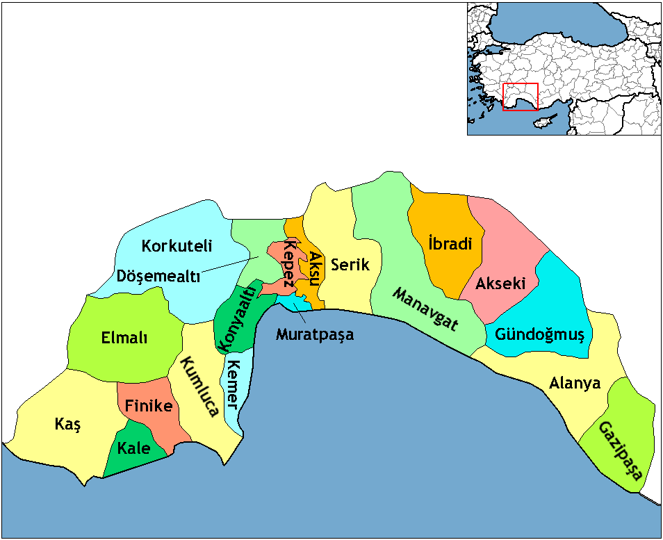
English: Map of the districts of Antalya province in Turkey. Created by Rarelibra 16:59, 1 December 2006 (UTC) for public domain use, using MapInfo Professional v8.5 and various mapping resources. Edited by One Homo Sapiens Corrected text where İ,Ş,ı,ğ,or ş occurs in name. Source: [statoids-com]. Increased font size and enhanced color differences among adjacent districts. |
| Tarehe | 1 Desemba 2006 (original upload date) |
| Chanzo | No machine-readable source provided. Own work assumed (based on copyright claims). |
| Mwandishi | No machine-readable author provided. Rarelibra assumed (based on copyright claims). |
Hatimiliki
| I, the copyright holder of this work, release this work into the public domain. This applies worldwide. Katika nchi zingine hii haiwezekani kisheria; kama ni hivyo: I grant anyone the right to use this work for any purpose, without any conditions, unless such conditions are required by law. |
This image was intentionally uploaded with a border. Please do not remove the border. Upload a new version under a different filename without a border if you want a version without a border.
|
Historia ya faili
Bonyeza tarehe/saa kuona faili kama ilivyoonekana wakati huo.
| Tarehe/Saa | Picha ndogo | Vipimo | Mtumiaji | Maelezo | |
|---|---|---|---|---|---|
| sasa hivi | 23:24, 18 Februari 2018 | | 954 × 777 (46 KB) | Effeietsanders | Removed border by cropping 10 % horizontally and 5 % vertically using CropTool with precise mode. |
| 19:18, 1 Januari 2009 |  | 1,056 × 816 (67 KB) | Onur | {{Information |Description= |Source= |Date= |Author= |Permission= |other_versions= }} | |
| 20:43, 28 Desemba 2008 |  | 1,056 × 816 (39 KB) | One Homo Sapiens | Corrected text where İ,Ş,ı,ğ,or ş occurs in name. Source: [statoids-com]. Increased font size and enhanced color differences among adjacent districts. | |
| 16:59, 1 Desemba 2006 |  | 1,056 × 816 (32 KB) | Rarelibra | Map of the districts of Antalya province in Turkey. Created by ~~~~ for public domain use, using MapInfo Professional v8.5 and various mapping resources. |
Matumizi ya faili
Kurasa hizi 22 zimeunganishwa na faili hili:
Matumizi ya faili ulimwenguni
Wiki nyingine hutumia faili hizi:
- Matumizi kwa azb.wikipedia.org
- Matumizi kwa az.wikipedia.org
- Matumizi kwa ba.wikipedia.org
- Matumizi kwa be.wikipedia.org
- Matumizi kwa br.wikipedia.org
- Matumizi kwa ca.wikipedia.org
- Matumizi kwa da.wikipedia.org
- Matumizi kwa de.wikipedia.org
- Alanya
- Antalya (Provinz)
- Gazipaşa
- Akseki
- Kumluca (Antalya)
- Vorlage:Navigationsleiste Landkreise der Provinz Antalya
- Serik (Landkreis)
- Korkuteli (Landkreis)
- Finike (Landkreis)
- Elmalı (Landkreis)
- İbradı (Landkreis)
- Kemer (Landkreis, Antalya)
- Kaş (Landkreis)
- Gündoğmuş
- Demre
- Aksu (Antalya)
- Döşemealtı
- Kepez (Antalya)
- Konyaaltı
- Muratpaşa
- Matumizi kwa diq.wikipedia.org
- Matumizi kwa en.wikipedia.org
Tazama matumizi zaidi ya kimataifa ya faili hii.