Faili:BritishEmpire1919.png
Ukubwa wa hakikisho: piseli 800 × 409. Ukubwa zingine: piseli 320 × 163 | piseli 640 × 327 | piseli 1,425 × 728.
Faili halisi (piseli 1,425 × 728, saizi ya faili: 52 KB, aina ya MIME: image/png)
| Faili hili linatoka Wikimedia Commons. Maelezo yapo kule kwenye ukurasa wake wa maelezo unaonekana hapo chini.
|

|
This historical map image could be re-created using vector graphics as an SVG file. This has several advantages; see Commons:Media for cleanup for more information. If an SVG form of this image is available, please upload it and afterwards replace this template with
{{vector version available|new image name}}.
It is recommended to name the SVG file “BritishEmpire1919.svg”—then the template Vector version available (or Vva) does not need the new image name parameter. |
Muhtasari
| Maelezo |
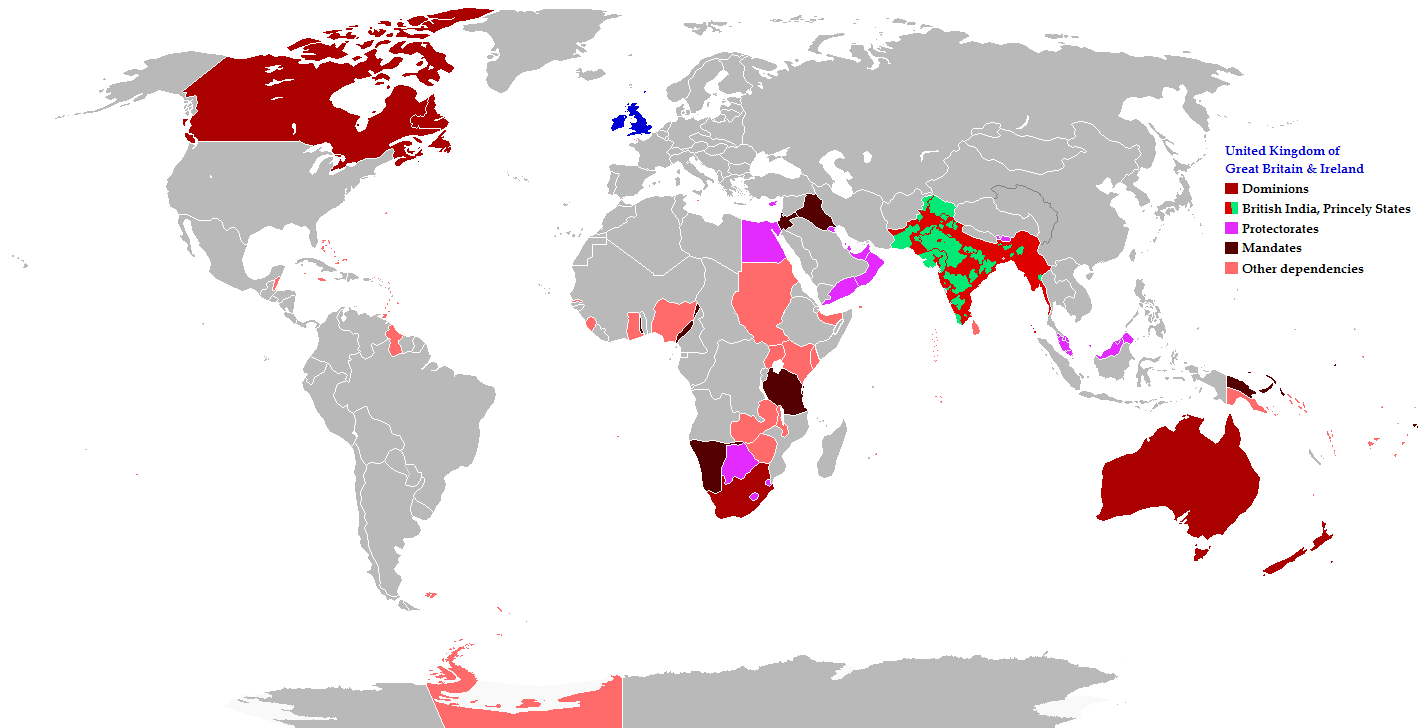
English: Map of the British Empire in 1919 showing all the territories, including the dominions, colonies, protectorates and mandates, ruled or administered by the United Kingdom and its successor states during that year.
Français : Carte de l'Empire britannique en 1919 illustrant tous les territoires, tels que les dominions, colonies, protectorats et mandats, gouvernés ou administrés par le Royaume-Uni ou ses États successeurs cette année-là.
Español: Un mapa de todas las afirmaciones oficiales territorial del Imperio Británico que se celebró en 1919 que identifica qué tipo de celebración estaba presente en todas las posesiones durante ese año.
Deutsch: Eine Karte aller offiziellen territorialen Ansprüche des Britischen Empire, die es im Jahre 1919 hatte, nach Art der Besitzungen in diesem Jahr.
فارسی: نقشه بیمورد از همه ادعاهای ارضی رسمی امپراطوری بریتانیا که در سال 1919 که برای شناسایی نوع برگزاری در حال حاضر تمام اموال در آن سال برگزار شد.
Português: Mapa de todos os territórios reclamados pelo Império Britânico, em 1919, que identifica o tipo de presença britânica no local naquele ano. |
| Tarehe | |
| Chanzo |
The following: |
| Mwandishi | Maps & Lucy |
| Ruhusa (Kutumia faili tena) |
Released into the public domain (by the author). |
| Matoleo mengine | العربيَّة |
Legend
Deutsch (de):
Hatimiliki
This file is licensed under the Creative Commons Attribution-Share Alike 2.5 Generic license.
- Uko huru:
- kushiriki – kunakili na kusambaza kazi hiyo
- kwa remix – kurekebisha kazi
- Chini ya masharti yafuatayo:
- sifa – Ni lazima utoe mkopo unaofaa, utoe kiungo cha leseni, na uonyeshe ikiwa mabadiliko yalifanywa. Unaweza kufanya hivyo kwa njia yoyote inayofaa, lakini si kwa njia yoyote inayopendekeza mtoa leseni akuidhinishe wewe au matumizi yako.
Historia ya faili
Bonyeza tarehe/saa kuona faili kama ilivyoonekana wakati huo.
| Tarehe/Saa | Picha ndogo | Vipimo | Mtumiaji | Maelezo | |
|---|---|---|---|---|---|
| sasa hivi | 08:26, 31 Oktoba 2021 | | 1,425 × 728 (52 KB) | Randomastwritter | jubaland |
| 20:43, 17 Novemba 2014 |  | 1,425 × 728 (61 KB) | GrenaderGD44 | Убраны артефакты с карты в районе Антарктиды | |
| 01:40, 17 Novemba 2014 |  | 1,425 × 728 (65 KB) | GrenaderGD44 | Бутан - протекторат с 1910 года | |
| 18:36, 9 Machi 2014 |  | 1,425 × 625 (39 KB) | Htonl | Bechuanaland, Basutoland and Swaziland were protectorates | |
| 20:02, 18 Juni 2011 |  | 1,425 × 625 (55 KB) | Maps & Lucy | The British Empire, Mongolia and the Soviet Union all recognized Tibet as an independent state and the British Empire via British India were heavily involved in Tibet's independence. | |
| 19:05, 7 Mei 2011 |  | 1,425 × 625 (58 KB) | Quigley | Correct China's borders closer to what was internationally recognized at the time | |
| 23:55, 15 Desemba 2010 |  | 1,425 × 625 (55 KB) | Maps & Lucy | Added protectorates and Princely States | |
| 22:47, 10 Desemba 2010 |  | 1,425 × 625 (53 KB) | Maps & Lucy | Papua was a colony not a dominion, Gold Coast did not include British Togoland and British Togoland was a mandate. | |
| 18:20, 7 Novemba 2010 |  | 1,425 × 625 (59 KB) | Spesh531 | fix mistake in botswana | |
| 18:19, 7 Novemba 2010 |  | 1,425 × 625 (56 KB) | Spesh531 | really a way to revert. use this version |
Matumizi ya faili
Ukurasa huu umeunganishwa na faili hili:
Matumizi ya faili ulimwenguni
Wiki nyingine hutumia faili hizi:
- Matumizi kwa af.wikipedia.org
- Matumizi kwa ar.wikipedia.org
- Matumizi kwa azb.wikipedia.org
- Matumizi kwa az.wikipedia.org
- Matumizi kwa ba.wikipedia.org
- Matumizi kwa be-tarask.wikipedia.org
- Matumizi kwa be.wikipedia.org
- Matumizi kwa bg.wikipedia.org
- Matumizi kwa bs.wikipedia.org
- Matumizi kwa bxr.wikipedia.org
- Matumizi kwa cdo.wikipedia.org
- Matumizi kwa de.wikipedia.org
- Matumizi kwa el.wikipedia.org
- Matumizi kwa en.wikipedia.org
- Matumizi kwa eo.wikipedia.org
- Matumizi kwa fiu-vro.wikipedia.org
- Matumizi kwa fi.wikipedia.org
- Matumizi kwa fr.wikipedia.org
- Matumizi kwa he.wikipedia.org
- Matumizi kwa hif.wikipedia.org
- Matumizi kwa hr.wikipedia.org
- Matumizi kwa hy.wikipedia.org
- Matumizi kwa ia.wikipedia.org
- Matumizi kwa id.wikipedia.org
- Matumizi kwa is.wikipedia.org
- Matumizi kwa ja.wikipedia.org
- Matumizi kwa kk.wikipedia.org
- Matumizi kwa krc.wikipedia.org
- Matumizi kwa lez.wikipedia.org
- Matumizi kwa lo.wikipedia.org
- Matumizi kwa lv.wikipedia.org
- Matumizi kwa ms.wikipedia.org
- Matumizi kwa mwl.wikipedia.org
- Matumizi kwa my.wikipedia.org
- Matumizi kwa nl.wikipedia.org
- Matumizi kwa nn.wikipedia.org
- Matumizi kwa pnb.wikipedia.org
- Matumizi kwa qu.wikipedia.org
- Matumizi kwa ru.wikipedia.org
Tazama matumizi zaidi ya kimataifa ya faili hii.