Faili:Cape Town 2011 population density map.svg

Size of this PNG preview of this SVG file: piseli 405 × 599. Ukubwa zingine: piseli 162 × 240 | piseli 324 × 480 | piseli 519 × 768 | piseli 692 × 1,024 | piseli 1,385 × 2,048 | piseli 771 × 1,140.
Faili halisi (faili la SVG, husemwa kuwa piseli 771 × 1,140, saizi ya faili: 761 KB)
| Faili hili linatoka Wikimedia Commons. Maelezo yapo kule kwenye ukurasa wake wa maelezo unaonekana hapo chini.
|
Muhtasari
| Maelezo |
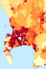
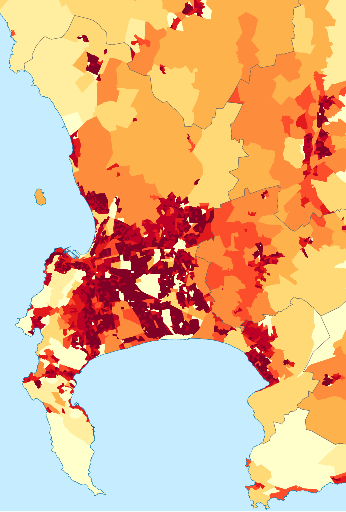
English: Population density map of the City of Cape Town, Western Cape, South Africa, from the 2011 Census, at the "Small Area" level.
<1 inhabitant/km²
1–3 inhabitants/km²
3–10 inhabitants/km²
10–30 inhabitants/km²
30–100 inhabitants/km²
100–300 inhabitants/km²
300–1000 inhabitants/km²
1000–3000 inhabitants/km²
>3000 inhabitants/km² |
| Tarehe | |
| Chanzo | Statistics South Africa's Census 2011 is the source of the basic population data. The map results from my own processing of the data. |
| Mwandishi | Htonl |
| Ruhusa (Kutumia faili tena) |
http://beta2.statssa.gov.za/?page_id=425 |
Hatimiliki
The following license applies to the population data on which the map is based:
 |
The copyright holder of this file allows anyone to use it
for any purpose, provided that the user acknowledges Stats SA as the source of the basic data wherever they process, apply, utilise, publish or distribute the data, and also that they specify that the relevant application and analysis (where applicable) result from their own processing of the data..
Usage notes:
|
|
Please check that the conditions given above are compliant to the Commons licensing policy. Most importantly, derivative work and commercial use must be allowed.
|
The following tag applies to the map itself:
| I, the copyright holder of this work, release this work into the public domain. This applies worldwide. Katika nchi zingine hii haiwezekani kisheria; kama ni hivyo: I grant anyone the right to use this work for any purpose, without any conditions, unless such conditions are required by law. |
Historia ya faili
Bonyeza tarehe/saa kuona faili kama ilivyoonekana wakati huo.
| Tarehe/Saa | Picha ndogo | Vipimo | Mtumiaji | Maelezo | |
|---|---|---|---|---|---|
| sasa hivi | 18:05, 26 Septemba 2015 | | 771 × 1,140 (761 KB) | Htonl | style/size tweak |
| 14:25, 13 Oktoba 2013 |  | 718 × 1,045 (505 KB) | Htonl | == {{int:filedesc}} == {{Information |Description={{en|1=Population density map of the City of Cape Town, Western Cape, South Africa, from the 2011 Census, at the "Small Area" level. {{legend|#ffffcc|<1 inhabitant/km²}} {{legend|#ffeda0|1–3 inhab... |
Matumizi ya faili
Ukurasa huu umeunganishwa na faili hili:
Matumizi ya faili ulimwenguni
Wiki nyingine hutumia faili hizi:
- Matumizi kwa be.wikipedia.org
- Matumizi kwa de.wikipedia.org
- Matumizi kwa en.wikipedia.org
- Matumizi kwa gl.wikipedia.org
- Matumizi kwa gu.wikipedia.org
- Matumizi kwa he.wikipedia.org
- Matumizi kwa hu.wikipedia.org
- Matumizi kwa hy.wikipedia.org
- Matumizi kwa ja.wikipedia.org
- Matumizi kwa ka.wikipedia.org
- Matumizi kwa ko.wikipedia.org
- Matumizi kwa mk.wikipedia.org
- Matumizi kwa nso.wikipedia.org
- Matumizi kwa pt.wikipedia.org
- Matumizi kwa ro.wikipedia.org
- Matumizi kwa uk.wikipedia.org
- Matumizi kwa xh.wikipedia.org