Faili:Cyclone Catarina 2004.jpg
Ukubwa wa hakikisho: piseli 600 × 600. Ukubwa zingine: piseli 240 × 240 | piseli 480 × 480 | piseli 768 × 768 | piseli 1,024 × 1,024 | piseli 2,048 × 2,048 | piseli 4,000 × 4,000.
Faili halisi (piseli 4,000 × 4,000, saizi ya faili: 2.46 MB, aina ya MIME: image/jpeg)
| Faili hili linatoka Wikimedia Commons. Maelezo yapo kule kwenye ukurasa wake wa maelezo unaonekana hapo chini.
|
Muhtasari
| Maelezo |
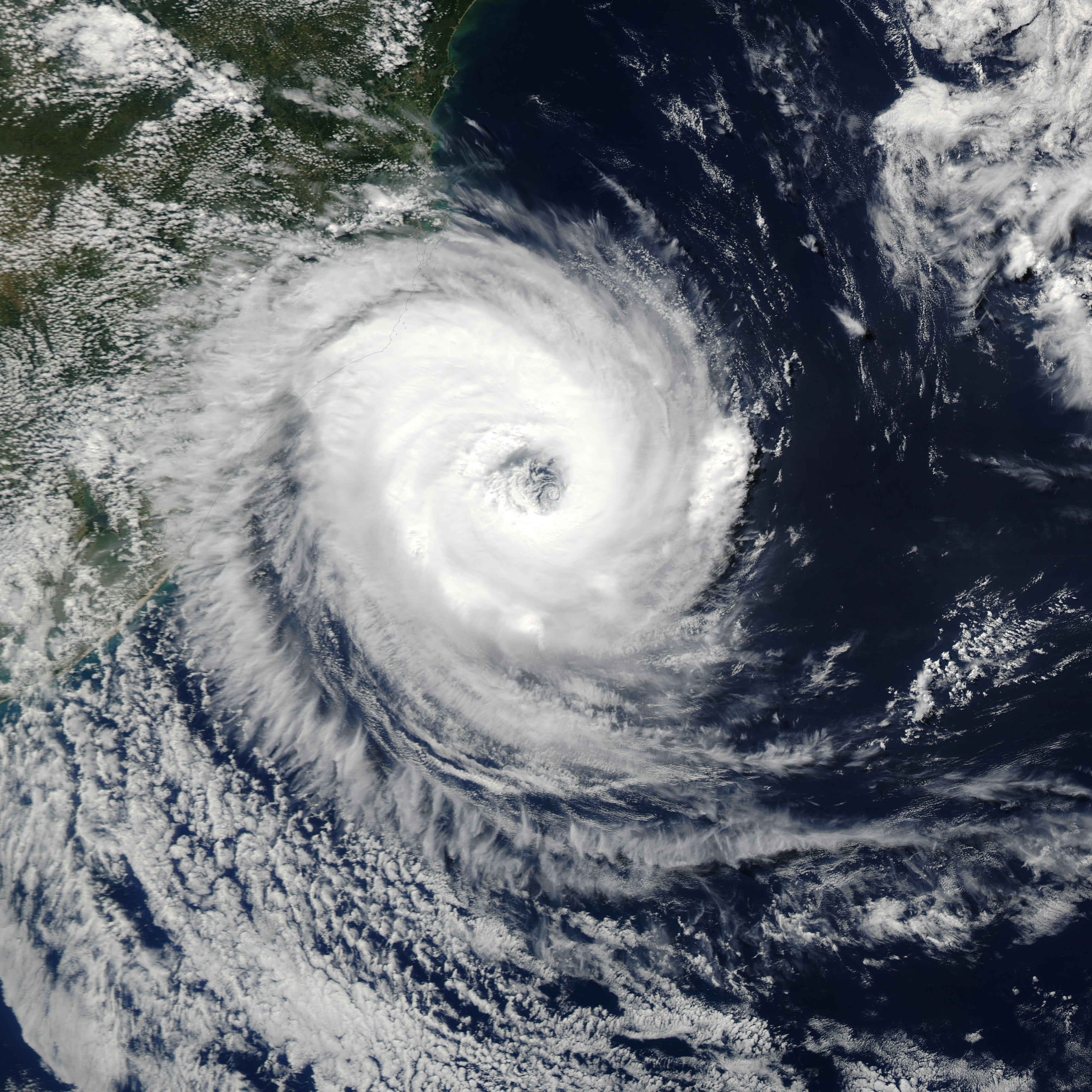
The MODIS instrument onboard NASA's Aqua satellite captured this true-color image of a rare tropical cyclone in the South Atlantic ocean just off the coast of Santa Catarina and Rio Grande do Sul, Brazil's southernmost states. The National Hurricane Center in Miami estimated the storm was a full-fledged, Category I hurricane with central winds between 75 mph and 80 mph (121 kph to 129 kph), making it the first hurricane in the South Atlantic in recorded history. Brazilian scientists however, have disagreed, saying the storm had top winds of 50 mph to 56 mph (80 kph to 90 kph), far below the 75 mph (121 kph) threshold of a hurricane. It's interesting to note that the Brazilian Center for Weather Prediction and Climatic Studies does not operate any anemometers (wind measuring devices) in the area or have any Hurricane Hunter aircraft to fly through the storm. All sides were basing their guesses on satellite data only. |
|||||
| Tarehe | ||||||
| Chanzo | http://visibleearth.nasa.gov/view_rec.php?id=6288 | |||||
| Mwandishi | Image courtesy Jeff Schmaltz, MODIS Land Rapid Response Team at NASA GSFC. | |||||
| Ruhusa (Kutumia faili tena) |
|
|||||
| Matoleo mengine | Image:Catarina 27 mar 2004 1630Z.jpg |

Historia ya faili
Bonyeza tarehe/saa kuona faili kama ilivyoonekana wakati huo.
| Tarehe/Saa | Picha ndogo | Vipimo | Mtumiaji | Maelezo | |
|---|---|---|---|---|---|
| sasa hivi | 04:29, 2 Januari 2010 | | 4,000 × 4,000 (2.46 MB) | Juliancolton | Reverted to version as of 18:58, 1 September 2006 |
| 17:55, 29 Desemba 2009 |  | 4,000 × 4,000 (2.12 MB) | Supportstorm | Image Adjustment: Auto levels on contrast and color | |
| 18:58, 1 Septemba 2006 |  | 4,000 × 4,000 (2.46 MB) | Good kitty | == Summary == {{Information |Description=The MODIS instrument onboard NASA's Aqua satellite captured this true-color image of a rare tropical cyclone in the South Atlantic ocean just off the coast of Santa Catarina and Rio Grande do Sul, Brazil's southern |
Matumizi ya faili
Ukurasa huu umeunganishwa na faili hili:
Matumizi ya faili ulimwenguni
Wiki nyingine hutumia faili hizi:
- Matumizi kwa de.wikipedia.org
- Matumizi kwa en.wikipedia.org
- List of South America hurricanes
- Portal:Tropical cyclones/Featured article/List of South America tropical cyclones
- Portal:Tropical cyclones/Anniversaries/March
- Portal:Tropical cyclones/Anniversaries/March/28
- Wikipedia:Featured picture candidates/September-2008
- Wikipedia:Featured picture candidates/Cyclone Catarina 2004.jpg
- Wikipedia:Wikipedia Signpost/2009-01-03/Dispatches
- Wikipedia talk:Wikipedia Signpost/2009-01-03/Dispatches
- History of tropical cyclone naming
- User:LightandDark2000/My Notable Storms
- User:RandomInfinity17/Unusual areas of tropical cyclogenesis
- Matumizi kwa fr.wikipedia.org
- Matumizi kwa gu.wikipedia.org
- Matumizi kwa hi.wikipedia.org
- Matumizi kwa hu.wikipedia.org
- Matumizi kwa it.wikipedia.org
- Matumizi kwa ko.wikipedia.org
- Matumizi kwa ms.wikipedia.org
- Matumizi kwa mwl.wikipedia.org
- Matumizi kwa pl.wikipedia.org
- Matumizi kwa pt.wikipedia.org
- Matumizi kwa ro.wikipedia.org
- Matumizi kwa ta.wikipedia.org
- Matumizi kwa uk.wikipedia.org
- Matumizi kwa vi.wikipedia.org
- Matumizi kwa zh.wikipedia.org