Faili:El salvador map.png
Hakuna saizi kubwa zaidi.
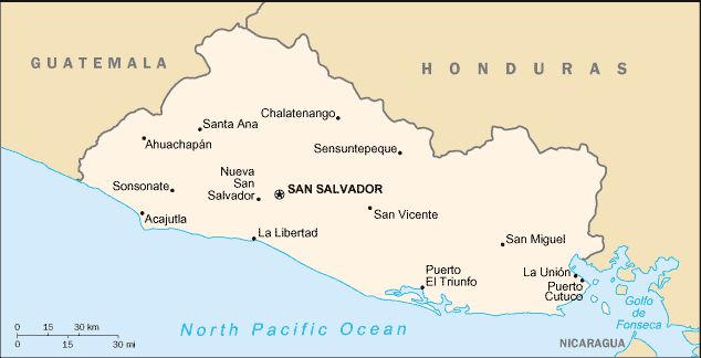
El_salvador_map.png (piseli 634 × 324, saizi ya faili: 10 KB, aina ya MIME: image/png)
| Faili hili linatoka Wikimedia Commons. Maelezo yapo kule kwenye ukurasa wake wa maelezo unaonekana hapo chini.
|

|
This locator map image could be re-created using vector graphics as an SVG file. This has several advantages; see Commons:Media for cleanup for more information. If an SVG form of this image is available, please upload it and afterwards replace this template with
{{vector version available|new image name}}.
It is recommended to name the SVG file “El salvador map.svg”—then the template Vector version available (or Vva) does not need the new image name parameter. |
from [1] Source: en:Image:El salvador sm04.png
![[1]](http://www.lib.utexas.edu/maps/cia04/el_salvador_sm04.gif)
This image is in the public domain because it contains materials that originally came from the United States Central Intelligence Agency's World Factbook.
|
 |
Historia ya faili
Bonyeza tarehe/saa kuona faili kama ilivyoonekana wakati huo.
| Tarehe/Saa | Picha ndogo | Vipimo | Mtumiaji | Maelezo | |
|---|---|---|---|---|---|
| sasa hivi | 21:27, 27 Machi 2006 | | 634 × 324 (10 KB) | ~Pyb | from [http://www.lib.utexas.edu/maps/cia04/el_salvador_sm04.gif] Source: en:Image:El salvador sm04.png {{PD-USGov-CIA-WF}} |
Matumizi ya faili
Ukurasa huu umeunganishwa na faili hili:
Matumizi ya faili ulimwenguni
Wiki nyingine hutumia faili hizi:
- Matumizi kwa als.wikipedia.org
- Matumizi kwa da.wikipedia.org
- Matumizi kwa de.wikipedia.org
- Matumizi kwa de.wiktionary.org
- Matumizi kwa dsb.wikipedia.org
- Matumizi kwa en.wikipedia.org
- Matumizi kwa eo.wikipedia.org
- Matumizi kwa frr.wikipedia.org
- Matumizi kwa fr.wikipedia.org
- Matumizi kwa id.wikipedia.org
- Matumizi kwa ja.wikipedia.org
- Matumizi kwa kk.wikipedia.org
- Matumizi kwa ku.wikipedia.org
- Matumizi kwa lt.wiktionary.org
- Matumizi kwa mr.wikipedia.org
- Matumizi kwa nl.wikipedia.org
- Matumizi kwa ro.wikipedia.org
- Matumizi kwa ru.wikipedia.org
- Matumizi kwa sco.wikipedia.org
- Matumizi kwa simple.wikipedia.org
- Matumizi kwa uk.wikipedia.org
- Matumizi kwa vi.wikipedia.org
- Matumizi kwa xmf.wikipedia.org