Faili:First century Iudaea province.gif
Faili halisi(piseli 575 × 792, saizi ya faili: 31 KB, aina ya MIME: image/gif)

Faili hili linatoka Wikimedia Commons. Maelezo yapo kule kwenye ukurasa wake wa maelezo unaonekana hapo chini.
Commons ni mahali mtandaoni pa kuhifadhia jalada na hati za picha na sauti zenye leseni huria. Unaweza kuisadia.
This map image could be re-created using vector graphics as an SVG file. This has several advantages; see Commons:Media for cleanup for more information. If an SVG form of this image is available, please upload it and afterwards replace this template with {{vector version available|new image name}}.


It is recommended to name the SVG file “First century Iudaea province.svg”—then the template Vector version available (or Vva) does not need the new image name parameter.

Muhtasari

Maelezo
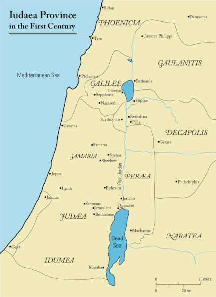
English: This is a map of first century Iudaea Province that I created using Illustrator CS2. I traced this image for the general geographic features. I then manually input data from maps found in a couple of sources.
  • Robert W. Funk and the Jesus Seminar. The Acts of Jesus. HarperSanFrancisco: 1998. p. xxiv.
  • Michael Grant. Jesus: An Historian's Review of the Gospels. Charles Scribner's Sons: 1977. p. 65-67.
  • John P. Meier. A Marginal Jew. Doubleday: 1991. p. 1:434.
Tarehe 23 Machi 2006 (original upload date)
Chanzo Transferred from en.wikipedia to Commons.
Mwandishi Andrew c at Kiingereza Wikipedia
Ruhusa
(Kutumia faili tena)
Released under the GNU Free Documentation License or CC-BY.
Matoleo mengine العربيَّة

Hatimiliki

Andrew c from en.wikipedia.org, the copyright holder of this work, hereby publishes it under the following license:
GNU head Ruhusa inakubalika kunakili, kusambaza na/au kurekebisha chini ya matakwa ya GNU Free Documentation License, Toleo 1.2 au toleo lolote lile la baadaye ambalo litachapishwa na Free Software Foundation; lisilo na Sehemu Tofauti, lisilo na Maandishi-Kava-Kwa-Mbele, na lisilo na Maandishi-Kava-Kwa -Nyuma. Nakala ya hatimiliki inajumlishwa kwenye sehemu ilioitwa GNU Free Documentation License. Subject to disclaimers.
w:en:Creative Commons
sifa
This file is licensed under the Creative Commons Attribution 3.0 Unported license.
Sifa: Wikipedia User:Andrew c
Uko huru:
  • kushiriki – kunakili na kusambaza kazi hiyo
  • kwa remix – kurekebisha kazi
Chini ya masharti yafuatayo:
  • sifa – Ni lazima utoe mkopo unaofaa, utoe kiungo cha leseni, na uonyeshe ikiwa mabadiliko yalifanywa. Unaweza kufanya hivyo kwa njia yoyote inayofaa, lakini si kwa njia yoyote inayopendekeza mtoa leseni akuidhinishe wewe au matumizi yako.
Public domain I, the copyright holder of this work, release this work into the public domain. This applies worldwide.
Katika nchi zingine hii haiwezekani kisheria; kama ni hivyo:
I grant anyone the right to use this work for any purpose, without any conditions, unless such conditions are required by law.

Kumbukumbu ya upakizaji wa asili

The original description page was here. All following user names refer to en.wikipedia.
  • 2006-03-24 18:48 Andrew c 575×792×8 (32374 bytes) This is a map of First Century Palestine that I created using Illustrator CS2. I traced [http://commons.wikimedia.org/wiki/Image:Map_of_administrative_regions_in_Israel.png this] image for the general geographic features. I then manually input data from m
  • 2006-03-23 19:48 Andrew c 587×790×8 (30752 bytes) This is a map of First Century Palestine that I created using Illustrator CS2. I traced [http://commons.wikimedia.org/wiki/Image:Map_of_administrative_regions_in_Israel.png this] image for the general geographic features. I then manually input data from m

Captions

Add a one-line explanation of what this file represents
Judaea province in the 1st Century CE

Items portrayed in this file

depicts Kiingereza

23 Machi 2006

MIME type Kiingereza

image/gif

checksum Kiingereza

e488e0183049d2138c916ccc7a24c107807f12b7

data size Kiingereza

32,019 Baiti

792 pixel

width Kiingereza

575 pixel

Historia ya faili

Bonyeza tarehe/saa kuona faili kama ilivyoonekana wakati huo.

Tarehe/SaaPicha ndogoVipimoMtumiajiMaelezo
sasa hivi11:47, 18 Septemba 2011Picha ndogo ya toleo la 11:47, 18 Septemba 2011575 × 792 (31 KB)OnceinawhileRemoved region-name "Philistia", as incorrect
14:05, 13 Septemba 2007Picha ndogo ya toleo la 14:05, 13 Septemba 2007575 × 792 (32 KB)Liftarn{{SVG|map}} {{Information |Description=This is a map of first century en:Iudaea Province that I created using Illustrator CS2. I traced [http://commons.wikimedia.org/wiki/Image:Map_of_administrative_regions_in_Israel.png this] image for the general g
00:29, 30 Aprili 2006Picha ndogo ya toleo la 00:29, 30 Aprili 2006575 × 792 (32 KB)Duende~commonswikihttp://en.wikipedia.org/wiki/Image:First_century_palestine.gif

Kurasa hizi 3 zimeunganishwa na faili hili:

Matumizi ya faili ulimwenguni

Wiki nyingine hutumia faili hizi:

Tazama matumizi zaidi ya kimataifa ya faili hii.