Faili:Group of Seven (G7) Countries.svg

Size of this PNG preview of this SVG file: piseli 800 × 406. Ukubwa zingine: piseli 320 × 162 | piseli 640 × 325 | piseli 1,024 × 520 | piseli 1,280 × 650 | piseli 2,560 × 1,300 | piseli 2,754 × 1,398.
Faili halisi (faili la SVG, husemwa kuwa piseli 2,754 × 1,398, saizi ya faili: 1.06 MB)
| Faili hili linatoka Wikimedia Commons. Maelezo yapo kule kwenye ukurasa wake wa maelezo unaonekana hapo chini.
|
complete the map of Egypt 🇪🇬
Muhtasari
| Maelezo |
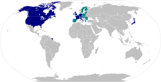
English: Group of Seven (G7) countries
Member countries in the G7
European Union members (which are not part of G7 individually) |
||||
| Tarehe | |||||
| Chanzo | BlankMap-World.svg updated with membership info from here: Group of Seven | ||||
| Mwandishi | Authors of File:BlankMap-World.svg | ||||
| Ruhusa (Kutumia faili tena) |
|
||||
| SVG genesis |
|

_Countries.svg)
Historia ya faili
Bonyeza tarehe/saa kuona faili kama ilivyoonekana wakati huo.
| Tarehe/Saa | Picha ndogo | Vipimo | Mtumiaji | Maelezo | |
|---|---|---|---|---|---|
| sasa hivi | 18:18, 17 Mei 2023 | | 2,754 × 1,398 (1.06 MB) | Rogerjamesdsouza | Reverted to version as of 11:34, 1 July 2021 (UTC) |
| 16:50, 5 Februari 2023 |  | 2,754 × 1,398 (1.11 MB) | DinoSoupCanada | Reverted to version as of 16:03, 8 June 2021 (UTC) | |
| 11:34, 1 Julai 2021 |  | 2,754 × 1,398 (1.06 MB) | Cherkash | Reverted to version as of 01:37, 15 January 2020 (UTC) no real reason; also, it clearly indicates "no-Inkscape" in the image description | |
| 16:03, 8 Juni 2021 |  | 2,754 × 1,398 (1.11 MB) | RaviC | Added a stroke to indicate states with both individual G7 and EU membership | |
| 01:37, 15 Januari 2020 |  | 2,754 × 1,398 (1.06 MB) | Cherkash | updated to the most recent version of the base map | |
| 03:12, 27 Oktoba 2018 |  | 2,560 × 1,314 (1.06 MB) | Fibonacci | Redone with proper CSS | |
| 09:07, 20 Mei 2018 |  | 863 × 443 (1.2 MB) | NordNordWest | Greenland is not part of the EU | |
| 06:12, 8 Desemba 2017 |  | 863 × 443 (1.66 MB) | Noahnmf | User created page with UploadWizard |
Matumizi ya faili
Ukurasa huu umeunganishwa na faili hili:
Matumizi ya faili ulimwenguni
Wiki nyingine hutumia faili hizi:
- Matumizi kwa af.wikipedia.org
- Matumizi kwa als.wikipedia.org
- Matumizi kwa ar.wikipedia.org
- Matumizi kwa az.wikipedia.org
- Matumizi kwa bg.wikipedia.org
- Matumizi kwa bn.wikipedia.org
- Matumizi kwa bs.wikipedia.org
- Matumizi kwa ca.wikipedia.org
- Matumizi kwa cs.wikipedia.org
- Matumizi kwa cy.wikipedia.org
- Matumizi kwa da.wikipedia.org
- Matumizi kwa de.wikipedia.org
- Matumizi kwa en.wikipedia.org
- Matumizi kwa en.wikinews.org
- Matumizi kwa eo.wikiquote.org
- Matumizi kwa es.wikipedia.org
- Matumizi kwa et.wikipedia.org
- Matumizi kwa eu.wikipedia.org
- Matumizi kwa fa.wikipedia.org
- Matumizi kwa fi.wikipedia.org
- Matumizi kwa fo.wikipedia.org
- Matumizi kwa fr.wikipedia.org
- Groupe des sept (économie)
- Jean-Claude Juncker
- Sonny Perdue
- Chancelier de l'Échiquier
- Tom Vilsack
- Antonio Tajani
- Joe Biden
- Lord grand chancelier
- Liste des ministres des Affaires étrangères
- Tarō Asō
- David Cameron
- Ministère de l'Europe et des Affaires étrangères
- Ministère de la Défense
- Dominic LeBlanc
- Lawrence MacAulay
- Office des Affaires étrangères (Allemagne)
- Christophe Béchu
- Bruno Le Maire
- Mark Holland
- Omar Alghabra
- Liste des ministres de la Défense
- Liste des ministres des Finances
- Liste des ministres de l'Intérieur actuels
Tazama matumizi zaidi ya kimataifa ya faili hii.
_Countries.svg)
_Countries.svg)