Faili:Map of Missouri NA.png

Ukubwa wa hakikisho: piseli 776 × 600. Ukubwa zingine: piseli 311 × 240 | piseli 621 × 480 | piseli 994 × 768 | piseli 1,280 × 989 | piseli 2,122 × 1,640.
Faili halisi (piseli 2,122 × 1,640, saizi ya faili: 2.09 MB, aina ya MIME: image/png)
| Faili hili linatoka Wikimedia Commons. Maelezo yapo kule kwenye ukurasa wake wa maelezo unaonekana hapo chini.
|
Muhtasari
| Maelezo |
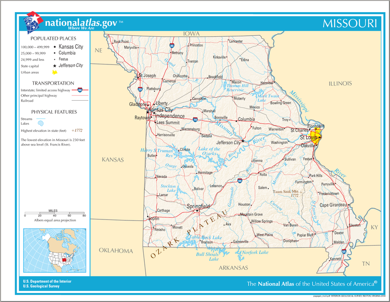
English: Map of Missouri. |
| Tarehe | |
| Chanzo | National Atlas |
| Mwandishi |
Hatimiliki
This map was obtained from an edition of the National Atlas of the United States. Like almost all works of the U.S. federal government, works from the National Atlas are in the public domain in the United States.
Online access: NationalAtlas.gov | 1970 print edition: Library of Congress, Perry-Castañeda Library
|
Historia ya faili
Bonyeza tarehe/saa kuona faili kama ilivyoonekana wakati huo.
| Tarehe/Saa | Picha ndogo | Vipimo | Mtumiaji | Maelezo | |
|---|---|---|---|---|---|
| sasa hivi | 21:20, 14 Agosti 2006 | | 2,122 × 1,640 (2.09 MB) | Huebi~commonswiki | {{Information| |Description=Map of Missouri |Source=[http://www.nationalatlas.gov National Atlas] }} Category:Maps of the United States Category:Maps of Missouri {{PD-USGov-Atlas}} |
Matumizi ya faili
Ukurasa huu umeunganishwa na faili hili:
Matumizi ya faili ulimwenguni
Wiki nyingine hutumia faili hizi:
- Matumizi kwa da.wikipedia.org
- Matumizi kwa de.wikipedia.org
- Matumizi kwa en.wikipedia.org
- Matumizi kwa hu.wikipedia.org
- Matumizi kwa incubator.wikimedia.org
- Matumizi kwa it.wikipedia.org
- Matumizi kwa mr.wikipedia.org
- Matumizi kwa szl.wikipedia.org
- Matumizi kwa zea.wikipedia.org