Faili:Northumberland UK locator map 2010.svg

Size of this PNG preview of this SVG file: piseli 494 × 600. Ukubwa zingine: piseli 198 × 240 | piseli 395 × 480 | piseli 633 × 768 | piseli 843 × 1,024 | piseli 1,687 × 2,048 | piseli 1,108 × 1,345.
Faili halisi (faili la SVG, husemwa kuwa piseli 1,108 × 1,345, saizi ya faili: 302 KB)
| Faili hili linatoka Wikimedia Commons. Maelezo yapo kule kwenye ukurasa wake wa maelezo unaonekana hapo chini.
|
Muhtasari
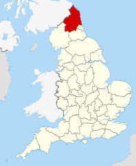
| Maelezo | Location of the ceremonial county of Northumberland within England. |
| Tarehe | |
| Chanzo |
National Geospatial-Intelligence Agency
|
| Mwandishi | Nilfanion |
Hatimiliki
I, the copyright holder of this work, hereby publish it under the following licenses:
Faili hii imeidhinishwa chini ya Creative Commons Attribution- Attribution-Share Alike 3.0 Unported leseni.
- Uko huru:
- kushiriki – kunakili na kusambaza kazi hiyo
- kwa remix – kurekebisha kazi
- Chini ya masharti yafuatayo:
- sifa – Ni lazima utoe mkopo unaofaa, utoe kiungo cha leseni, na uonyeshe ikiwa mabadiliko yalifanywa. Unaweza kufanya hivyo kwa njia yoyote inayofaa, lakini si kwa njia yoyote inayopendekeza mtoa leseni akuidhinishe wewe au matumizi yako.

|
Ruhusa inakubalika kunakili, kusambaza na/au kurekebisha chini ya matakwa ya GNU Free Documentation License, Toleo 1.2 au toleo lolote lile la baadaye ambalo litachapishwa na Free Software Foundation; lisilo na Sehemu Tofauti, lisilo na Maandishi-Kava-Kwa-Mbele, na lisilo na Maandishi-Kava-Kwa -Nyuma. Nakala ya hatimiliki inajumlishwa kwenye sehemu ilioitwa GNU Free Documentation License. |
Unaweza kuchagua leseni ya chaguo lako.

|
This is one of the images forming part of the Valued image set: Locator maps of the Ceremonial counties of England on Wikimedia Commons. The image set has been assessed under the valued image set criteria and is considered the most valued set on Commons within the scope:
Locator maps of the Ceremonial counties of England
You can see its nomination at Commons:Valued image candidates/Locator maps of English ceremonial counties. |
Historia ya faili
Bonyeza tarehe/saa kuona faili kama ilivyoonekana wakati huo.
| Tarehe/Saa | Picha ndogo | Vipimo | Mtumiaji | Maelezo | |
|---|---|---|---|---|---|
| sasa hivi | 23:09, 23 Novemba 2010 | | 1,108 × 1,345 (302 KB) | Nilfanion | == Summary == {{Information |Description=Location of the ceremonial county of Northumberland within England. |Source=Ordnance Survey [https://www.ordnancesurvey.co.uk/opendatadownload/products.html OpenData]: *Co |
Matumizi ya faili
Ukurasa huu umeunganishwa na faili hili:
Matumizi ya faili ulimwenguni
Wiki nyingine hutumia faili hizi:
- Matumizi kwa af.wikipedia.org
- Matumizi kwa ar.wikipedia.org
- Matumizi kwa ast.wikipedia.org
- Matumizi kwa be-tarask.wikipedia.org
- Matumizi kwa be.wikipedia.org
- Matumizi kwa bg.wikipedia.org
- Matumizi kwa br.wikipedia.org
- Matumizi kwa ca.wikipedia.org
- Matumizi kwa ceb.wikipedia.org
- Matumizi kwa cs.wikipedia.org
- Matumizi kwa dag.wikipedia.org
- Matumizi kwa el.wikipedia.org
- Matumizi kwa en.wikipedia.org
- Matumizi kwa eo.wikipedia.org
- Matumizi kwa es.wikipedia.org
- Matumizi kwa et.wikipedia.org
- Matumizi kwa fa.wikipedia.org
- Matumizi kwa fi.wikipedia.org
- Matumizi kwa fr.wiktionary.org
- Matumizi kwa ga.wikipedia.org
- Matumizi kwa gl.wikipedia.org
- Matumizi kwa hak.wikipedia.org
- Matumizi kwa hu.wikipedia.org
- Matumizi kwa ia.wikipedia.org
- Matumizi kwa ja.wikipedia.org
- Matumizi kwa ko.wikipedia.org
- Matumizi kwa la.wikipedia.org
- Matumizi kwa lld.wikipedia.org
- Matumizi kwa lt.wikipedia.org
- Matumizi kwa lv.wikipedia.org
- Matumizi kwa www.mediawiki.org
- Matumizi kwa nl.wikipedia.org
- Matumizi kwa oc.wikipedia.org
- Matumizi kwa os.wikipedia.org
- Matumizi kwa pl.wikipedia.org
- Matumizi kwa pl.wikivoyage.org
- Matumizi kwa pl.wiktionary.org
- Matumizi kwa pnb.wikipedia.org
- Matumizi kwa pt.wikipedia.org
- Matumizi kwa sco.wikipedia.org
Tazama matumizi zaidi ya kimataifa ya faili hii.