Faili:Possible definitions of the boundary between Europe and Asia.png
Faili halisi (piseli 729 × 1,129, saizi ya faili: 207 KB, aina ya MIME: image/png)
| Faili hili linatoka Wikimedia Commons. Maelezo yapo kule kwenye ukurasa wake wa maelezo unaonekana hapo chini.
|
Muhtasari
| Maelezo |
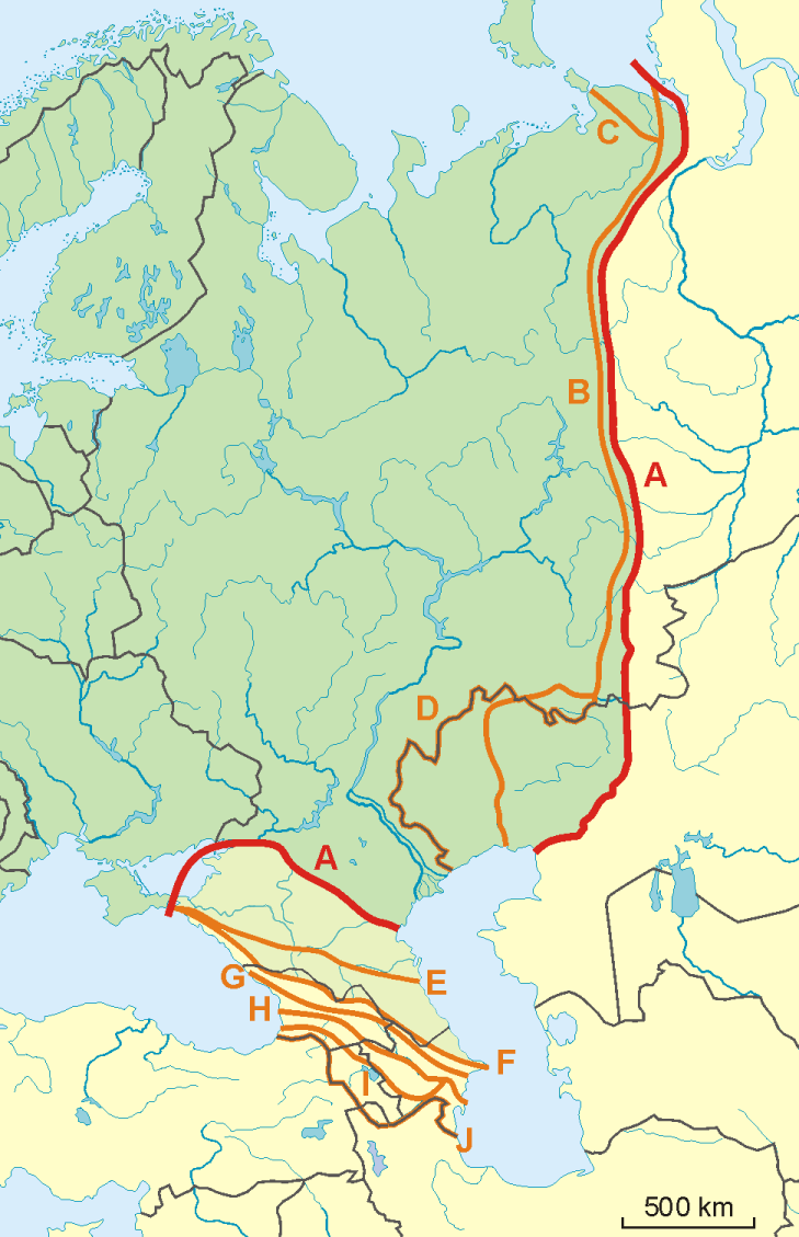
English: A map of possible definitions of the boundary between Asia and Europe.
Note that most of these lines are not referenced to any sources proposing them. The red line marked "A" is apparently the "Strahlenberg" definition commononly taught in Soviet-era Russia. See File:Historical Europe-Asia boundaries 1700 to 1900.png for a map which is actually based on references. The modern mainstream definition used by the UN (see also this) are marked "B" (Urals and Ural River) and "F" (Caucasus watershed). Lines C, D, E, G, H, I and J are currently without reference. Red line - "Strahlenberg" border, allegedly also used by the International Geographical Union [1]
Orange lines - other variants of border:
Polski: Mapa wariantów przebiegów granicy pomiędzy Europą a Azją
linie pomarańczowe - inne warianty przebiegu granicy:
|
| Tarehe | 09-04-2008 |
| Chanzo | Kazi yangu |
| Mwandishi | Aotearoa |
| Matoleo mengine | Image:TransAsia m.png, File:Historical Europe-Asia boundaries 1700 to 1900.png |
Hatimiliki

|
Ruhusa inakubalika kunakili, kusambaza na/au kurekebisha chini ya matakwa ya GNU Free Documentation License, Toleo 1.2 au toleo lolote lile la baadaye ambalo litachapishwa na Free Software Foundation; lisilo na Sehemu Tofauti, lisilo na Maandishi-Kava-Kwa-Mbele, na lisilo na Maandishi-Kava-Kwa -Nyuma. Nakala ya hatimiliki inajumlishwa kwenye sehemu ilioitwa GNU Free Documentation License. |
- Uko huru:
- kushiriki – kunakili na kusambaza kazi hiyo
- kwa remix – kurekebisha kazi
- Chini ya masharti yafuatayo:
- sifa – Ni lazima utoe mkopo unaofaa, utoe kiungo cha leseni, na uonyeshe ikiwa mabadiliko yalifanywa. Unaweza kufanya hivyo kwa njia yoyote inayofaa, lakini si kwa njia yoyote inayopendekeza mtoa leseni akuidhinishe wewe au matumizi yako.
Historia ya faili
Bonyeza tarehe/saa kuona faili kama ilivyoonekana wakati huo.
| Tarehe/Saa | Picha ndogo | Vipimo | Mtumiaji | Maelezo | |
|---|---|---|---|---|---|
| sasa hivi | 08:34, 14 Novemba 2022 | | 729 × 1,129 (207 KB) | Рагин1987 | Dull shade of green up to the "F" line |
| 13:12, 19 Februari 2022 |  | 729 × 1,129 (205 KB) | Lojwe | Frame removed | |
| 20:29, 1 Oktoba 2010 |  | 735 × 1,134 (156 KB) | Bogomolov.PL | Reverted to version as of 08:57, 9 April 2008 | |
| 19:44, 1 Oktoba 2010 |  | 735 × 1,134 (137 KB) | Zé Carioca~commonswiki | Trying to fix the error we are facing on the articles. | |
| 15:56, 1 Oktoba 2010 |  | 735 × 1,134 (137 KB) | Gvogas | Inclusion of the Miles Clark route line. (sorry for the tries, my internet gave problems). | |
| 15:55, 1 Oktoba 2010 |  | 735 × 1,134 (137 KB) | Gvogas | Reverted to version as of 15:52, 1 October 2010 | |
| 15:54, 1 Oktoba 2010 |  | 735 × 1,134 (137 KB) | Gvogas | (Inclusion of the Miles Clark route line.) | |
| 15:52, 1 Oktoba 2010 |  | 735 × 1,134 (137 KB) | Gvogas | Inclusion of the Miles Clark route line. | |
| 08:57, 9 Aprili 2008 |  | 735 × 1,134 (156 KB) | Aotearoa | {{Information |Description=Map of Europe (green) - Asia (yellow) border. Red line (A) - border accoring to International Geographical Union and most European geographers, orange lines - other variants of border. |Source=własna praca |Date=09-04-2008 | |
Matumizi ya faili
Ukurasa huu umeunganishwa na faili hili:
Matumizi ya faili ulimwenguni
Wiki nyingine hutumia faili hizi:
- Matumizi kwa am.wikipedia.org
- Matumizi kwa ar.wikipedia.org
- Matumizi kwa arz.wikipedia.org
- Matumizi kwa az.wikipedia.org
- Matumizi kwa ba.wikipedia.org
- Matumizi kwa be.wikipedia.org
- Matumizi kwa bn.wikipedia.org
- Matumizi kwa ca.wikipedia.org
- Matumizi kwa ce.wikipedia.org
- Matumizi kwa cs.wikipedia.org
- Matumizi kwa de.wikipedia.org
- Eurasien
- Portal:Mauern und Grenzen
- Liste interkontinentaler Staaten
- Wikipedia Diskussion:WikiProjekt Geographie/Archiv/2013-1
- Wikipedia:Löschkandidaten/28. Februar 2016
- Wikipedia Diskussion:WikiProjekt Kategorien/Archiv/2016-II
- Wikipedia Diskussion:Kurier/Archiv/2017/10
- Vorlage Diskussion:Navigationsleiste Kraftwerke
- Wikipedia Diskussion:Kurier/Archiv/2022/08
- Matumizi kwa en.wikipedia.org
- Matumizi kwa et.wikipedia.org
- Matumizi kwa hr.wikipedia.org
- Kategorija:Arktičkooceanski slijev (Europa)
- Kategorija:Arktičkooceanski slijev (Azija)
- Kategorija:Mora Arktičkog oceana
- Kategorija:Reljefni oblici u Arktičkom oceanu
- Kategorija:Mora Arktičkog oceana (Azija)
- Kategorija:Mora Arktičkog oceana (Europa)
- Kategorija:Reljefni oblici u Arktičkom oceanu (Azija)
- Kategorija:Tjesnaci Arktičkog oceana (Europa)
- Kategorija:Vodene mase Arktičkog oceana (Europa)
- Kategorija:Reljefni oblici u Arktičkom oceanu (Europa)
- Kategorija:Tjesnaci Arktičkog oceana (Azija)
- Kategorija:Vodene mase Arktičkog oceana (Azija)
- Kategorija:Karsko more
- Predložak:Granica Europe i Azije
- Kategorija:Zaljevi Arktičkog oceana (Azija)
- Kategorija:Zaljevi Arktičkog oceana (Europa)
- Kategorija:Estuariji Arktičkog oceana (Azija)
- Kategorija:Estuariji Tihog oceana (Azija)
- Matumizi kwa hu.wikipedia.org
- Matumizi kwa hy.wikipedia.org
Tazama matumizi zaidi ya kimataifa ya faili hii.