Faili:SouthAfricaOMC.png

Ukubwa wa hakikisho: piseli 542 × 599. Ukubwa zingine: piseli 217 × 240 | piseli 434 × 480 | piseli 695 × 768 | piseli 926 × 1,024 | piseli 1,367 × 1,511.
Faili halisi (piseli 1,367 × 1,511, saizi ya faili: 128 KB, aina ya MIME: image/png)
| Faili hili linatoka Wikimedia Commons. Maelezo yapo kule kwenye ukurasa wake wa maelezo unaonekana hapo chini.
|
Muhtasari
| Maelezo |
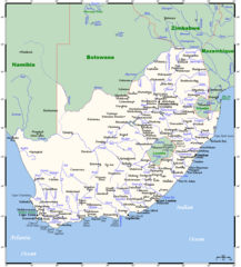
English: A map showing South Africa's cities, main towns, selected villages, rivers, and its highest peak. This map's source is here, with the uploader's modifications, and the GMT homepage says that the tools are released under the GNU General Public License. |
| Tarehe | 20 Desemba 2007 (original upload date) |
| Chanzo | Transferred from en.wikipedia to Commons by Mario1952 using CommonsHelper. |
| Mwandishi |
Kelisi at Kiingereza Wikipedia. Later version(s) were uploaded by JMK at en.wikipedia. This map's source is here, with the uploader's modifications, and the GMT homepage says that the tools are released under the GNU General Public License. |
Hatimiliki
Kelisi from en.wikipedia.org, the copyright holder of this work, hereby publishes it under the following license:
| Faili hii imeidhinishwa chini ya Creative Commons Attribution- Attribution-Share Alike 3.0 Unported leseni. Subject to disclaimers. | ||
| Sifa: Kelisi from en.wikipedia.org | ||
shiriki sawa – Ukichanganya, kubadilisha, au kujenga juu ya nyenzo, lazima usambaze michango yako chini ya same or compatible license kama ya awali. | ||
| This licensing tag was added to this file as part of the GFDL licensing update. |

|
Ruhusa inakubalika kunakili, kusambaza na/au kurekebisha chini ya matakwa ya GNU Free Documentation License, Toleo 1.2 au toleo lolote lile la baadaye ambalo litachapishwa na Free Software Foundation; lisilo na Sehemu Tofauti, lisilo na Maandishi-Kava-Kwa-Mbele, na lisilo na Maandishi-Kava-Kwa -Nyuma. Nakala ya hatimiliki inajumlishwa kwenye sehemu ilioitwa GNU Free Documentation License. Subject to disclaimers. |
Kumbukumbu ya upakizaji wa asili
The original description page was here. All following user names refer to en.wikipedia.
- 2007-12-20 10:55 JMK 1367×1511× (109398 bytes) Update under GFDL licence.
- 2007-12-20 10:19 JMK 1367×1511× (109349 bytes) Update under GFDL licence.
- 2007-12-20 09:25 JMK 1367×1511× (109369 bytes) Update under GFDL licence. ~~~~
- 2007-08-21 00:13 Kelisi 1366×1511× (93673 bytes) Updating towns' names.
- 2007-08-19 16:19 Kelisi 1366×1511× (93854 bytes) == Summary == A map showing South Africa's cities, main towns, selected villages, rivers and its highest peak. This map's source is [http://www.aquarius.ifm-geomar.de/ here], with the uploader's modifications, and the [http://gmt.soest.hawaii.edu/ GMT hom
Historia ya faili
Bonyeza tarehe/saa kuona faili kama ilivyoonekana wakati huo.
| Tarehe/Saa | Picha ndogo | Vipimo | Mtumiaji | Maelezo | |
|---|---|---|---|---|---|
| sasa hivi | 05:55, 23 Agosti 2023 | | 1,367 × 1,511 (128 KB) | Kelisi | tweaking |
| 05:47, 4 Aprili 2023 |  | 1,367 × 1,511 (128 KB) | Kelisi | Two more placename changes | |
| 05:44, 29 Juni 2022 |  | 1,367 × 1,511 (128 KB) | Kelisi | Several more names plotted | |
| 17:34, 1 Aprili 2022 |  | 1,367 × 1,511 (128 KB) | Kelisi | Sizeable town unaccountably overlooked. | |
| 06:00, 5 Februari 2022 |  | 1,367 × 1,511 (128 KB) | Kelisi | Several more names plotted | |
| 03:36, 3 Februari 2022 |  | 1,367 × 1,511 (128 KB) | Kelisi | Several more names plotted | |
| 07:46, 7 Januari 2022 |  | 1,367 × 1,511 (128 KB) | Kelisi | A few placename changes and one misspelling corrected | |
| 18:37, 29 Juni 2020 |  | 1,367 × 1,511 (128 KB) | Kelisi | Name changes: Cala→Kala Mafikeng→Mahikeng Nelspruit→Mbombela Piet Retief→eMkhondo | |
| 04:53, 29 Juni 2020 |  | 1,367 × 1,511 (128 KB) | Kelisi | Grahamstown→Makhanda | |
| 20:05, 20 Agosti 2019 |  | 1,367 × 1,511 (126 KB) | Kelisi | Swaziland is now called Eswatini. |
Matumizi ya faili
Ukurasa huu umeunganishwa na faili hili:
Matumizi ya faili ulimwenguni
Wiki nyingine hutumia faili hizi:
- Matumizi kwa en.wikinews.org
- Matumizi kwa ja.wikipedia.org
- Matumizi kwa pl.wikipedia.org
- Matumizi kwa pt.wikipedia.org
- Matumizi kwa ru.wikipedia.org
- Matumizi kwa simple.wikipedia.org
- Matumizi kwa sk.wikipedia.org
- Matumizi kwa uk.wikipedia.org
- Matumizi kwa www.wikidata.org
- Matumizi kwa xmf.wikipedia.org