Faili:Taunus - Deutsche Mittelgebirge, Serie A-de.png

Faili halisi (piseli 2,300 × 1,500, saizi ya faili: 5.05 MB, aina ya MIME: image/png)
| Faili hili linatoka Wikimedia Commons. Maelezo yapo kule kwenye ukurasa wake wa maelezo unaonekana hapo chini.
|
Muhtasari
| Maelezo |
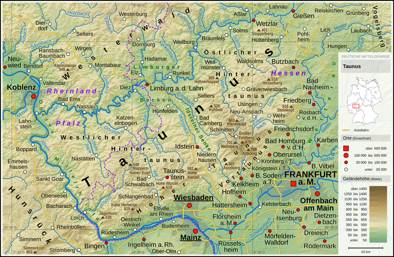
English: Topographic map of the Taunus
Deutsch: Topografische Karte des Taunus |
||||||||||||||||||
| Tarehe | |||||||||||||||||||
| Chanzo |
Own work using: |
||||||||||||||||||
| Mwandishi | Thoroe | ||||||||||||||||||
| Matoleo mengine |
 Topographic maps of German low mountain ranges (A series)
This map series aims to show the major low mountain ranges of Germany in a uniform design. All maps are created on the same scale, and the background reliefs base upon the same color scheme. The reliefs are also available as separate files. You can find the making-of one of the maps in the German language Wikipedia (German only).
|
||||||||||||||||||


_-_Deutsche_Mittelgebirge,_Serie_A-de.png)
_-_Deutsche_Mittelgebirge,_Serie_A-de.png)
_-_Deutsche_Mittelgebirge,_Serie_A-de.png)
_-_Deutsche_Mittelgebirge,_Serie_A-de.png)
_-_Deutsche_Mittelgebirge,_Serie_A-de.png)
_-_Deutsche_Mittelgebirge,_Serie_A-de.png)
_-_Deutsche_Mittelgebirge,_Serie_A-de.png)
_-_Deutsche_Mittelgebirge,_Serie_A-de.png)
_-_Deutsche_Mittelgebirge,_Serie_A-de.png)
_-_Deutsche_Mittelgebirge,_Serie_A-de.png)
_-_Deutsche_Mittelgebirge,_Serie_A-de.png)
_-_Deutsche_Mittelgebirge,_Serie_A-de.png)
_-_Deutsche_Mittelgebirge,_Serie_A-de.png)
_-_Deutsche_Mittelgebirge,_Serie_A-de.png)
_-_Deutsche_Mittelgebirge,_Serie_A-de.png)
_-_Deutsche_Mittelgebirge,_Serie_A-de.png)
_-_Deutsche_Mittelgebirge,_Serie_A-de.png)
_-_Deutsche_Mittelgebirge,_Serie_A-de.png)
_-_Deutsche_Mittelgebirge,_Serie_A-de.png)
_-_Deutsche_Mittelgebirge,_Serie_A-de.png)
_-_Deutsche_Mittelgebirge,_Serie_A-de.png)
_-_Deutsche_Mittelgebirge,_Serie_A-de.png)
_-_Deutsche_Mittelgebirge,_Serie_A-de.png)
_-_Deutsche_Mittelgebirge,_Serie_A-de.png)
_-_Deutsche_Mittelgebirge,_Serie_A-de.png)
_-_Deutsche_Mittelgebirge,_Serie_A-de.png)
_-_Deutsche_Mittelgebirge,_Serie_A-de.png)
_-_Deutsche_Mittelgebirge,_Serie_A-de.png)
_-_Deutsche_Mittelgebirge,_Serie_A-de.png)
_-_Deutsche_Mittelgebirge,_Serie_A-de.png)
_-_Deutsche_Mittelgebirge,_Serie_A-de.png)
_-_Deutsche_Mittelgebirge,_Serie_A-de.png)
| This work contains information from OpenStreetMap, which is made available under the Open Database License (ODbL).
The ODbL does not require any particular license for maps produced from ODbL data. Prior to 1 August 2020, map tiles produced by the OpenStreetMap Foundation were licensed under the CC-BY-SA-2.0 license. Maps produced by other people may be subject to other licences. |

|
This map has been made or improved in the German Kartenwerkstatt (Map Lab). You can propose maps to improve as well.
|
Hatimiliki
- Uko huru:
- kushiriki – kunakili na kusambaza kazi hiyo
- kwa remix – kurekebisha kazi
- Chini ya masharti yafuatayo:
- sifa – Ni lazima utoe mkopo unaofaa, utoe kiungo cha leseni, na uonyeshe ikiwa mabadiliko yalifanywa. Unaweza kufanya hivyo kwa njia yoyote inayofaa, lakini si kwa njia yoyote inayopendekeza mtoa leseni akuidhinishe wewe au matumizi yako.
| Annotations | This image is annotated: View the annotations at Commons |
Historia ya faili
Bonyeza tarehe/saa kuona faili kama ilivyoonekana wakati huo.
| Tarehe/Saa | Picha ndogo | Vipimo | Mtumiaji | Maelezo | |
|---|---|---|---|---|---|
| sasa hivi | 23:16, 12 Januari 2017 | | 2,300 × 1,500 (5.05 MB) | Thoroe | City size fixes |
| 10:09, 5 Januari 2017 |  | 2,300 × 1,500 (5.05 MB) | Thoroe | minor additions | |
| 22:59, 4 Januari 2017 |  | 2,300 × 1,500 (5.05 MB) | Thoroe | some fixes | |
| 11:00, 4 Januari 2017 |  | 2,300 × 1,500 (5.03 MB) | Thoroe | {{Information |Description ={{en|1=Topographic map of the Taunus}} {{de|1=Topografische Karte des Taunus}} |Source ={{Own using}} *[http://gmt.soest.hawaii.edu Generic Mapping Tools (GMT)] with [http://dds.cr.us... |
Matumizi ya faili
Ukurasa huu umeunganishwa na faili hili:
Matumizi ya faili ulimwenguni
Wiki nyingine hutumia faili hizi:
- Matumizi kwa bg.wikipedia.org
- Matumizi kwa br.wikipedia.org
- Matumizi kwa de.wikipedia.org
- Taunus
- Einrich
- Benutzer:Gugganij
- Benutzer:Olaf2
- Vordertaunus
- Limburger Becken
- Hintertaunus
- Liste von Bergen und Erhebungen des Taunus
- Hoher Taunus
- Benutzer:Gustav moenus
- Benutzer:Hoff1980
- Benutzer:Thoroe
- Diskussion:Schneekoppe/Archiv
- Benutzer:Tommes
- Benutzer:Maschienenbau
- Benutzer:Thomas Wozniak (HSP)
- Benutzer:Wetterwolke
- Wikipedia:Kartenwerkstatt/Karte des Tages/Galerie
- Benutzer:GeisterPirat
- Wikipedia:Kartenwerkstatt/Archiv/2017-01
- Benutzer:Palitzsch250/Nostalgie
- Benutzer:Thoroe/Making of Thüringer Wald
- Matumizi kwa en.wikipedia.org
- Matumizi kwa en.wikivoyage.org
- Matumizi kwa eo.wikipedia.org
- Matumizi kwa es.wikipedia.org
- Matumizi kwa fa.wikipedia.org
- Matumizi kwa fr.wikipedia.org
- Matumizi kwa fy.wikipedia.org
- Matumizi kwa li.wikipedia.org
- Matumizi kwa nl.wikipedia.org
- Matumizi kwa no.wikipedia.org
- Matumizi kwa pt.wikipedia.org
- Matumizi kwa www.wikidata.org