Faili:Mapa del Confín del Imperio Romano.gif

Faili halisi (piseli 1,000 × 715, saizi ya faili: 53 KB, aina ya MIME: image/gif)
| Faili hili linatoka Wikimedia Commons. Maelezo yapo kule kwenye ukurasa wake wa maelezo unaonekana hapo chini.
|
Muhtasari
| Maelezo |
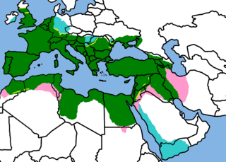
IMPORTANT IRELAND IS PAINTED BECAUSE THERE DID EXIST AN ATTEMPT TO INVADE IT, EVEN IF IT DIDN'T WORK. cyan means that the conquered land was never a Roman province because of
Map of the Roman Empire in it's greatest expansion, following the same proportional relations (that means, positions are exactly copied) of the Nuovo Atlante Storico De Agostini, by "Istituto Geografico De Agostini", [[ISBN 88-451-3698-5 Invalid ISBN]]. Novara 1995. The briefly occupated teritories (cyan and pink) are from the Corso di storia antica e medievale 1 (seconda edizione) by Augusto Camer and Renato Fabietti ISBN 88-08-24230-7 World shape is Image:A large blank world map with oceans marked in blue.gif
|
| Tarehe | 3 Oktoba 2006 (original upload date) |
| Chanzo | No machine-readable source provided. Own work assumed (based on copyright claims). |
| Mwandishi | No machine-readable author provided. Argentino assumed (based on copyright claims). |
Hatimiliki

|
Ruhusa inakubalika kunakili, kusambaza na/au kurekebisha chini ya matakwa ya GNU Free Documentation License, Toleo 1.2 au toleo lolote lile la baadaye ambalo litachapishwa na Free Software Foundation; lisilo na Sehemu Tofauti, lisilo na Maandishi-Kava-Kwa-Mbele, na lisilo na Maandishi-Kava-Kwa -Nyuma. Nakala ya hatimiliki inajumlishwa kwenye sehemu ilioitwa GNU Free Documentation License. |
| Faili hii imeidhinishwa chini ya Creative Commons Attribution- Attribution-Share Alike 3.0 Unported leseni. | ||
shiriki sawa – Ukichanganya, kubadilisha, au kujenga juu ya nyenzo, lazima usambaze michango yako chini ya same or compatible license kama ya awali. | ||
| This licensing tag was added to this file as part of the GFDL licensing update. |
- Uko huru:
- kushiriki – kunakili na kusambaza kazi hiyo
- kwa remix – kurekebisha kazi
- Chini ya masharti yafuatayo:
- sifa – Ni lazima utoe mkopo unaofaa, utoe kiungo cha leseni, na uonyeshe ikiwa mabadiliko yalifanywa. Unaweza kufanya hivyo kwa njia yoyote inayofaa, lakini si kwa njia yoyote inayopendekeza mtoa leseni akuidhinishe wewe au matumizi yako.
Historia ya faili
Bonyeza tarehe/saa kuona faili kama ilivyoonekana wakati huo.
| Tarehe/Saa | Picha ndogo | Vipimo | Mtumiaji | Maelezo | |
|---|---|---|---|---|---|
| sasa hivi | 15:11, 28 Julai 2010 | | 1,000 × 715 (53 KB) | Argentino | Reverted to version as of 23:57, 5 July 2007 |
| 16:56, 29 Januari 2010 |  | 1,000 × 715 (51 KB) | Persia2099 | minor change | |
| 16:54, 29 Januari 2010 |  | 1,000 × 715 (51 KB) | Persia2099 | minor change | |
| 16:52, 29 Januari 2010 |  | 1,000 × 715 (65 KB) | Persia2099 | minor change | |
| 23:57, 5 Julai 2007 |  | 1,000 × 715 (53 KB) | Argentino | New version of the map, adding the berber tribes and Arabia Felix. | |
| 17:22, 3 Oktoba 2006 |  | 910 × 589 (31 KB) | Argentino | Map of the Roman Empire in it's greatest expansion, following the same proportional relations (that means, positions are exactly copied) of the ''Nouovo Atlanes Storico De Agostini'', by "Instituto Geografico De Agostini", ISBN 88-451-3698-5. Novara 1995. |
Matumizi ya faili
Ukurasa huu umeunganishwa na faili hili:
Matumizi ya faili ulimwenguni
Wiki nyingine hutumia faili hizi:
- Matumizi kwa de.wikipedia.org
- Matumizi kwa en.wikipedia.org
- Matumizi kwa fa.wikipedia.org