Faili:Byzantine Constantinople-en.svg

Size of this PNG preview of this SVG file: piseli 662 × 600. Ukubwa zingine: piseli 265 × 240 | piseli 530 × 480 | piseli 848 × 768 | piseli 1,130 × 1,024 | piseli 2,261 × 2,048 | piseli 2,085 × 1,889.
Faili halisi (faili la SVG, husemwa kuwa piseli 2,085 × 1,889, saizi ya faili: 3.69 MB)
| Faili hili linatoka Wikimedia Commons. Maelezo yapo kule kwenye ukurasa wake wa maelezo unaonekana hapo chini.
|
Muhtasari
| Maelezo |
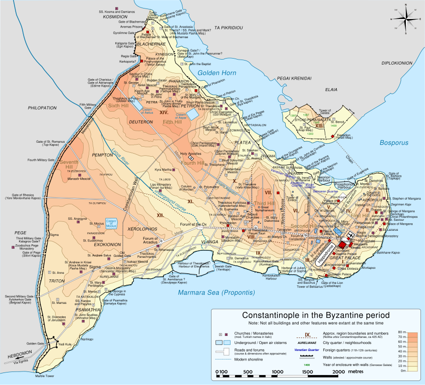
Deutsch: Topografische Karte Konstantinopels während des byzantinischen Zeitraums. Quelle: R. Janin, Constantinople Byzantine. Developpement urbain et repertoire topographique. Straßennetz und andere Einzelheiten basiert auf Dumbarton Oaks Papers 54. Kirchen, insb. nicht identifizierte und ausgegrabene Bauten sind aus dem The Byzantine Churches of Istanbul entnommen. Andere herausgegebenen Quellen wurden behilfsmäßig gebraucht. English: Topographical map of Constantinople during the Byzantine period. Main map source: R. Janin, Constantinople Byzantine. Developpement urbain et repertoire topographique. Road network and some other details based on Dumbarton Oaks Papers 54; data on many churches, especially unidentified ones, taken from the University of New York's The Byzantine Churches of Istanbul project. Other published maps and accounts of the city have been used for corroboration. Français : Carte en anglais de Constantinople à l'époque Byzantine. Source principale : R. Janin, Constantinople Byzantine. Développement urbain et répertoire topographique. Le réseau routier et d'autres détails proviennent de Dumbarton Oaks Papers 54. Les données concernant de nombreuses églises, en particulier celles non identifiées, viennent de l'université de New York : le projet The Byzantine Churches of Istanbul (Les églises byzantines d'Istanbul). D'autres cartes encore ont été utilisées pour recouper et vérifier les informations. Türkçe: tr:Konstantinopolis'in Bizans dönemindeki topografik haritası. Ana haritanın kaynağı: R. Janin, Constantinople Byzantine. Developpement urbain et repertoire topographique. Yol haritası ve bazı diğer ayrıntıların kaynağı: Dumbarton Oaks Papers 54; kiliseler, özellikle kimliği belirlenmemiş olanlar hakkında veriler, New York University'nin İstanbul'un Bizans Kiliseleri projesinden elde edilmiştir. Şehir hakkında yayımlanmış diğer harita ve metinler bu bilgileri doğrulamak için kullanılmıştır. Ελληνικά: Τοπογραφικός χάρτης Κωνσταντινουπόλεως κατά τη Βυζαντινή περίοδο. Βασική πηγή χάρτη: R. Janin, Constantinople Byzantine. Developpement urbain et repertoire topographique. Το οδικό δίκτυο και διάφορες άλλες λεπτομέρειες με βάση το Dumbarton Oaks Papers 54. Πληροφορίες για τις εκκλησίες, ιδιαίτερα τις μη ταυτοποιημένες, από την ιστοσελίδα The Byzantine Churches of Istanbul του Πανεπιστημίου της Νέας Υόρκης. Български: Топографска карта на Константинопол (Цариград) през византийския период. Източник: R. Janin, Constantinople Byzantine. Developpement urbain et repertoire topographique. Пътната мрежа и някои други детайли се основават на Dumbarton Oaks Papers 54 и други публикувани източници. |
||
| Tarehe | |||
| Chanzo | Kazi yangu | ||
| Mwandishi | Cplakidas | ||
| Matoleo mengine |
[] Full mapsSVG:
PNG:
Numeric versions
Regions
Roads
Derivative works of this file: | ||
| SVG | W3C-validity not checked.
|


| Camera location | | View this and other nearby images on: OpenStreetMap |
|---|
Hatimiliki
I, the copyright holder of this work, hereby publish it under the following licenses:
Faili hii imeidhinishwa chini ya Creative Commons Attribution- Attribution-Share Alike 3.0 Unported leseni.
- Uko huru:
- kushiriki – kunakili na kusambaza kazi hiyo
- kwa remix – kurekebisha kazi
- Chini ya masharti yafuatayo:
- sifa – Ni lazima utoe mkopo unaofaa, utoe kiungo cha leseni, na uonyeshe ikiwa mabadiliko yalifanywa. Unaweza kufanya hivyo kwa njia yoyote inayofaa, lakini si kwa njia yoyote inayopendekeza mtoa leseni akuidhinishe wewe au matumizi yako.

|
Ruhusa inakubalika kunakili, kusambaza na/au kurekebisha chini ya matakwa ya GNU Free Documentation License, Toleo 1.2 au toleo lolote lile la baadaye ambalo litachapishwa na Free Software Foundation; lisilo na Sehemu Tofauti, lisilo na Maandishi-Kava-Kwa-Mbele, na lisilo na Maandishi-Kava-Kwa -Nyuma. Nakala ya hatimiliki inajumlishwa kwenye sehemu ilioitwa GNU Free Documentation License. |
Unaweza kuchagua leseni ya chaguo lako.
Historia ya faili
Bonyeza tarehe/saa kuona faili kama ilivyoonekana wakati huo.
| Tarehe/Saa | Picha ndogo | Vipimo | Mtumiaji | Maelezo | |
|---|---|---|---|---|---|
| sasa hivi | 20:48, 13 Machi 2012 | | 2,085 × 1,889 (3.69 MB) | Sémhur | New version, with cleaned code and a new layer "editable text, hidden" made with font "Nimbus Sans L", containing all the texts, and other layers with text as path (not editables, but visibles). |
| 13:13, 15 Desemba 2009 |  | 2,050 × 1,850 (8.13 MB) | Cplakidas | larger & improved version, various corrections, Galata included | |
| 22:53, 8 Januari 2009 |  | 1,600 × 1,500 (5.79 MB) | Cplakidas | {{Information |Description= |Source= |Date= |Author= |Permission= |other_versions= }} | |
| 23:26, 14 Novemba 2008 |  | 1,600 × 1,500 (5.29 MB) | Cplakidas | attempt to get text right | |
| 11:38, 28 Oktoba 2008 |  | 1,600 × 1,500 (5.31 MB) | Cplakidas | final version (hopefully): added remaining churches & corrected locations, minor tweaks at places | |
| 19:10, 27 Oktoba 2008 |  | 1,600 × 1,500 (4.81 MB) | Cplakidas | completed outer land wall, fixed Golden Gate, fixed sea walls & added known gates, minor location corrections & additions | |
| 17:46, 25 Oktoba 2008 |  | 1,600 × 1,500 (2.74 MB) | Cplakidas | text into paths, enlarged map for improved readability | |
| 00:59, 24 Oktoba 2008 |  | 1,180 × 1,120 (371 KB) | Cplakidas | restored Times New Roman. | |
| 00:39, 24 Oktoba 2008 |  | 1,180 × 1,120 (369 KB) | Cplakidas | added posterns, alternate gate names, approx. roads in outer city, corrections on monastery locations, converted text to sans serif font | |
| 22:47, 23 Oktoba 2008 |  | 1,180 × 1,120 (328 KB) | Cplakidas | Reverted to version as of 23:25, 14 October 2008 |
Matumizi ya faili
Ukurasa huu umeunganishwa na faili hili:
Matumizi ya faili ulimwenguni
Wiki nyingine hutumia faili hizi:
- Matumizi kwa ca.wikipedia.org
- Matumizi kwa en.wikipedia.org
- Matumizi kwa es.wikipedia.org
- Matumizi kwa pl.wikipedia.org