Faili:Canada2.A2002165.1940.250m.jpg

Ukubwa wa hakikisho: piseli 461 × 599. Ukubwa zingine: piseli 184 × 240 | piseli 369 × 480 | piseli 591 × 768 | piseli 788 × 1,024 | piseli 1,575 × 2,048 | piseli 4,000 × 5,200.
Faili halisi (piseli 4,000 × 5,200, saizi ya faili: 2.83 MB, aina ya MIME: image/jpeg)
| Faili hili linatoka Wikimedia Commons. Maelezo yapo kule kwenye ukurasa wake wa maelezo unaonekana hapo chini.
|
Muhtasari
| Maelezo |
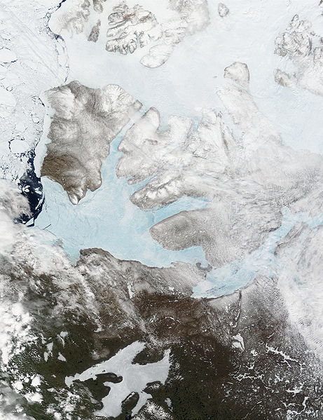
English: These Moderate resolution Imaging Spectroradiometer Images from June 14 and 16, 2002, show Banks Island (upper left) and Victoria Island (to the southeast) in the Arctic Ocean off northwest Canada. Left of center in each image is Amundsen Gulf, looking bright blue as this arm of the Beaufort Sea (at the southern end of the Arctic Ocean) begins to thaw. At the bottom of the images, the tundra of the Northwest Territories (left) and the Nunavut (right) Provinces of Canada is beginning to lose its winter snow cover. At bottom center of the portrait oriented image is Great Bear lake--still frozen. |
| Tarehe | June 14 and 16, 2002 |
| Chanzo | http://visibleearth.nasa.gov/view_rec.php?id=3342 |
| Mwandishi | Jacques Descloitres, MODIS Land Rapid Response Team, NASA/GSFC |
Hatimiliki
| This file is in the public domain in the United States because it was solely created by NASA. NASA copyright policy states that "NASA material is not protected by copyright unless noted". (See Template:PD-USGov, NASA copyright policy page or JPL Image Use Policy.) | ||
 |
Warnings:
|
Historia ya faili
Bonyeza tarehe/saa kuona faili kama ilivyoonekana wakati huo.
| Tarehe/Saa | Picha ndogo | Vipimo | Mtumiaji | Maelezo | |
|---|---|---|---|---|---|
| sasa hivi | 17:59, 20 Agosti 2008 | | 4,000 × 5,200 (2.83 MB) | Ando228 | {{Information |Description={{en|1=These Moderate resolution Imaging Spectroradiometer Images from June 14 and 16, 2002, show Banks Island (upper left) and Victoria Island (to the southeast) in the Arctic Ocean off northwest Canada. Left of center in each |
Matumizi ya faili
Ukurasa huu umeunganishwa na faili hili:
Matumizi ya faili ulimwenguni
Wiki nyingine hutumia faili hizi:
- Matumizi kwa af.wikipedia.org
- Matumizi kwa ar.wikipedia.org
- Matumizi kwa ast.wikipedia.org
- Matumizi kwa az.wikipedia.org
- Matumizi kwa be.wikipedia.org
- Matumizi kwa bg.wikipedia.org
- Matumizi kwa bn.wikipedia.org
- Matumizi kwa ca.wikipedia.org
- Matumizi kwa ceb.wikipedia.org
- Matumizi kwa cy.wikipedia.org
- Matumizi kwa da.wikipedia.org
- Matumizi kwa de.wikivoyage.org
- Matumizi kwa diq.wikipedia.org
- Matumizi kwa en.wikipedia.org
- Matumizi kwa es.wikipedia.org
- Matumizi kwa eu.wikipedia.org
- Matumizi kwa fa.wikipedia.org
- Matumizi kwa fi.wikipedia.org
- Matumizi kwa fr.wikipedia.org
- Matumizi kwa fr.wikivoyage.org
- Matumizi kwa fy.wikipedia.org
- Matumizi kwa ga.wikipedia.org
- Matumizi kwa gl.wikipedia.org
- Matumizi kwa he.wikipedia.org
- Matumizi kwa hu.wikipedia.org
- Matumizi kwa hy.wikipedia.org
- Matumizi kwa ilo.wikipedia.org
- Matumizi kwa is.wikipedia.org
- Matumizi kwa it.wikipedia.org
- Matumizi kwa ja.wikipedia.org
- Matumizi kwa ko.wikipedia.org
- Matumizi kwa ku.wikipedia.org
- Matumizi kwa la.wikipedia.org
- Matumizi kwa lv.wikipedia.org
- Matumizi kwa ml.wikipedia.org
- Matumizi kwa mzn.wikipedia.org
- Matumizi kwa nl.wikipedia.org
- Matumizi kwa nn.wikipedia.org
Tazama matumizi zaidi ya kimataifa ya faili hii.