Faili:ElectoralCollege1836.svg

Size of this PNG preview of this SVG file: piseli 577 × 593. Ukubwa zingine: piseli 234 × 240 | piseli 467 × 480 | piseli 747 × 768 | piseli 996 × 1,024 | piseli 1,993 × 2,048.
Faili halisi (faili la SVG, husemwa kuwa piseli 577 × 593, saizi ya faili: 175 KB)
| Faili hili linatoka Wikimedia Commons. Maelezo yapo kule kwenye ukurasa wake wa maelezo unaonekana hapo chini.
|
| U.S. presidential election maps (SVG) |
| See also: National Atlas maps (png) |
|
1789 · 1792 · 1796 · 1800 · 1804 · 1808 · 1812 · 1816 · 1820 · 1824 · 1828 · 1832 · 1836 · 1840 · 1844 · 1848 · 1852 · 1856 · 1860 · 1864 · 1868 · 1872 · 1876 · 1880 · 1884 · 1888 · 1892 · 1896 · 1900 · 1904 · 1908 · 1912 · 1916 · 1920 · 1924 · 1928 · 1932 · 1936 · 1940 · 1944 · 1948 · 1952 · 1956 · 1960 · 1964 · 1968 · 1972 · 1976 · 1980 · 1984 · 1988 · 1992 · 1996 · 2000 · 2004 · 2008 · 2012 · 2016 · 2020 · 2024 |
Muhtasari
| Maelezo |
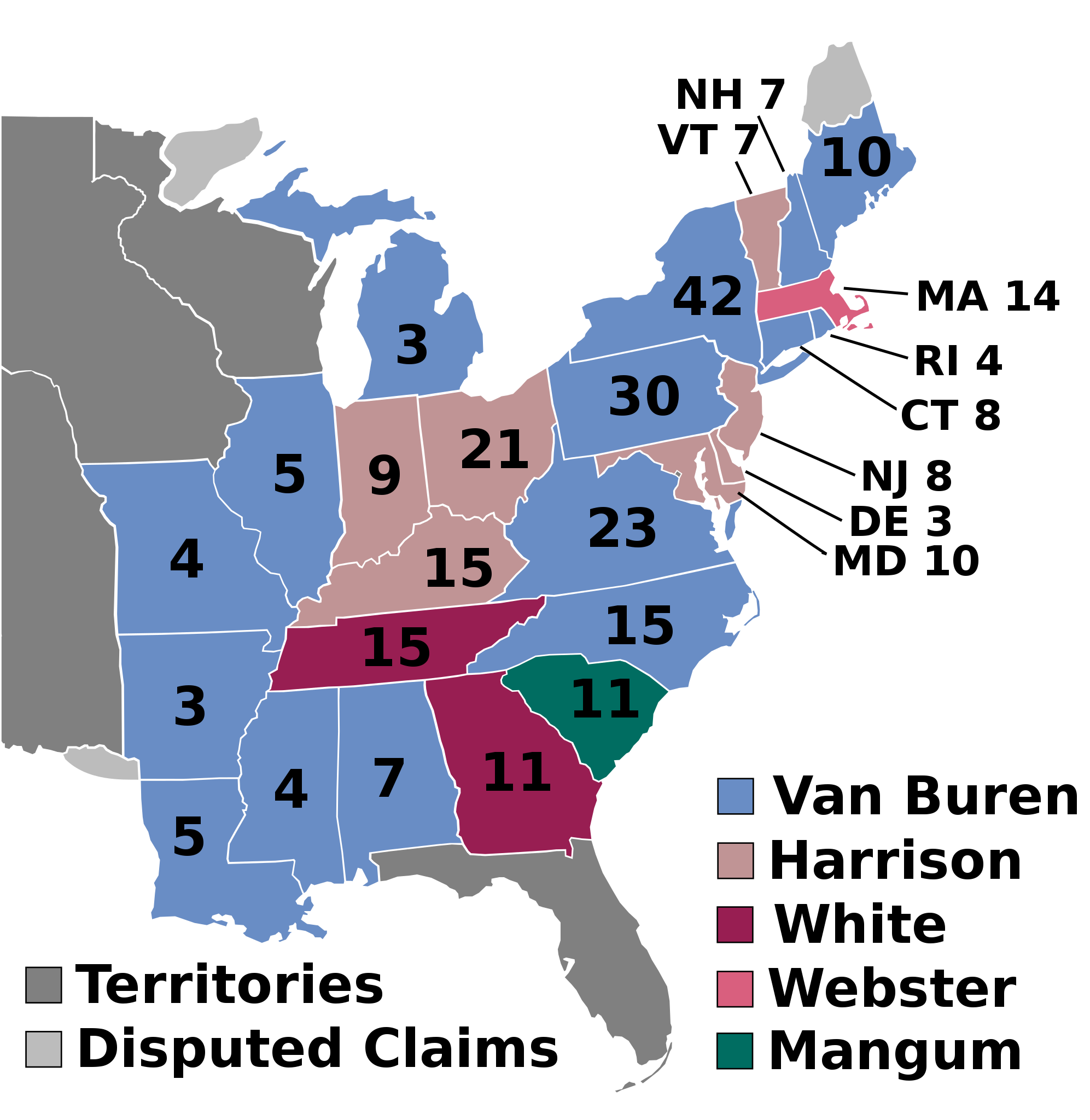
English: 1836 Electoral College |
| Tarehe | Tarehe isiyojulikana |
| Chanzo | Kazi yangu |
| Mwandishi | AndyHogan14 |
| SVG development | W3C-validity not checked. |
Hatimiliki
| I, the copyright holder of this work, release this work into the public domain. This applies worldwide. Katika nchi zingine hii haiwezekani kisheria; kama ni hivyo: I grant anyone the right to use this work for any purpose, without any conditions, unless such conditions are required by law. |
Historia ya faili
Bonyeza tarehe/saa kuona faili kama ilivyoonekana wakati huo.
| Tarehe/Saa | Picha ndogo | Vipimo | Mtumiaji | Maelezo | |
|---|---|---|---|---|---|
| sasa hivi | 22:36, 11 Julai 2018 | | 577 × 593 (175 KB) | Wow | fix |
| 10:00, 11 Julai 2018 |  | 577 × 593 (175 KB) | Wow | numbers | |
| 09:50, 11 Julai 2018 |  | 577 × 593 (175 KB) | Wow | disputed claim | |
| 21:36, 14 Novemba 2016 |  | 612 × 558 (85 KB) | Wow | Territories | |
| 03:08, 2 Agosti 2016 |  | 612 × 558 (81 KB) | Spartan7W | no need for entire west w/o states | |
| 20:34, 7 Juni 2016 |  | 1,034 × 572 (68 KB) | Rrostrom | replacement of existing file with spelling error fixed ("Magnum" --> "Mangum") {{PD-user|AndyHogan14}} | |
| 13:40, 8 Novemba 2011 |  | 1,034 × 572 (68 KB) | Citypeek | removed line | |
| 19:59, 31 Desemba 2008 |  | 1,020 × 593 (90 KB) | AndyHogan14 | {{Information |Description= |Source= |Date= |Author= |Permission= |other_versions= }} | |
| 19:57, 31 Desemba 2008 |  | 1,020 × 593 (90 KB) | AndyHogan14 | {{Information |Description={{en|1=1836 Electoral College}} |Source=Own work |Author=AndyHogan14 |Date= |Permission= |other_versions= }} <!--{{ImageUpload|full}}--> |
Matumizi ya faili
Ukurasa huu umeunganishwa na faili hili:
Matumizi ya faili ulimwenguni
Wiki nyingine hutumia faili hizi:
- Matumizi kwa da.wikipedia.org
- Matumizi kwa de.wikipedia.org
- Matumizi kwa el.wikipedia.org
- Matumizi kwa en.wikipedia.org
- Martin Van Buren
- 1836 United States presidential election
- Daniel Webster
- 1836 in the United States
- Electoral vote changes between United States presidential elections
- List of United States presidential election results by state
- Presidency of Andrew Jackson
- Presidency of Martin Van Buren
- United States presidential election
- Wikipedia:Graphics Lab/Illustration workshop/Archive/Nov 2011
- 1836 United States presidential election in Pennsylvania
- 1836 United States presidential election in Alabama
- 1836 United States presidential election in Arkansas
- 1836 United States presidential election in Connecticut
- 1836 United States presidential election in Delaware
- 1836 United States presidential election in Georgia
- 1836 United States presidential election in Illinois
- 1836 United States presidential election in Indiana
- 1836 United States presidential election in Kentucky
- 1836 United States presidential election in Louisiana
- 1836 United States presidential election in Maine
- 1836 United States presidential election in Maryland
- 1836 United States presidential election in Massachusetts
- 1836 United States presidential election in Mississippi
- 1836 United States presidential election in Missouri
- 1836 United States presidential election in New Hampshire
- 1836 United States presidential election in New Jersey
- 1836 United States presidential election in New York
- 1836 United States presidential election in North Carolina
- 1836 United States presidential election in Ohio
- 1836 United States presidential election in Rhode Island
- 1836 United States presidential election in Tennessee
- 1836 United States presidential election in Vermont
- 1836 United States presidential election in Virginia
- 1836 United States presidential election in South Carolina
- Template:State results of the 1836 U.S. presidential election
- 1836 United States elections
- 1836 United States presidential election in Michigan
- Template:1836 United States presidential election imagemap
- User:DukeOfDelTaco/U.S. Presidential Elections
- Matumizi kwa es.wikipedia.org
- Matumizi kwa fa.wikipedia.org
- Matumizi kwa fi.wikipedia.org
- Matumizi kwa fr.wikipedia.org
Tazama matumizi zaidi ya kimataifa ya faili hii.