Faili:Map of Nicobar and Andaman Islands-en.svg

Size of this PNG preview of this SVG file: piseli 263 × 598. Ukubwa zingine: piseli 105 × 240 | piseli 211 × 480 | piseli 337 × 768 | piseli 450 × 1,024 | piseli 900 × 2,048 | piseli 906 × 2,060.
Faili halisi (faili la SVG, husemwa kuwa piseli 906 × 2,060, saizi ya faili: 621 KB)
| Faili hili linatoka Wikimedia Commons. Maelezo yapo kule kwenye ukurasa wake wa maelezo unaonekana hapo chini.
|
Muhtasari
| Maelezo | |
| Tarehe | |
| Chanzo | Kazi yangu. Self-made in Inkscape. Based on the 1976 CIA Indian Ocean Atlas (Andaman nicobar 76.jpg); bathymetry and topography from SRTM30_PLUS. |
| Mwandishi | Oona Räisänen (Mysid) |
| Matoleo mengine |
Derivative works of this file: |
| SVG genesis |
Hatimiliki
I, the copyright holder of this work, hereby publish it under the following licenses:
Faili hii imeidhinishwa chini ya Creative Commons Attribution- Attribution-Share Alike 3.0 Unported leseni.
- Uko huru:
- kushiriki – kunakili na kusambaza kazi hiyo
- kwa remix – kurekebisha kazi
- Chini ya masharti yafuatayo:
- sifa – Ni lazima utoe mkopo unaofaa, utoe kiungo cha leseni, na uonyeshe ikiwa mabadiliko yalifanywa. Unaweza kufanya hivyo kwa njia yoyote inayofaa, lakini si kwa njia yoyote inayopendekeza mtoa leseni akuidhinishe wewe au matumizi yako.

|
Ruhusa inakubalika kunakili, kusambaza na/au kurekebisha chini ya matakwa ya GNU Free Documentation License, Toleo 1.2 au toleo lolote lile la baadaye ambalo litachapishwa na Free Software Foundation; lisilo na Sehemu Tofauti, lisilo na Maandishi-Kava-Kwa-Mbele, na lisilo na Maandishi-Kava-Kwa -Nyuma. Nakala ya hatimiliki inajumlishwa kwenye sehemu ilioitwa GNU Free Documentation License. |
Unaweza kuchagua leseni ya chaguo lako.
Historia ya faili
Bonyeza tarehe/saa kuona faili kama ilivyoonekana wakati huo.
| Tarehe/Saa | Picha ndogo | Vipimo | Mtumiaji | Maelezo | |
|---|---|---|---|---|---|
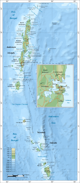
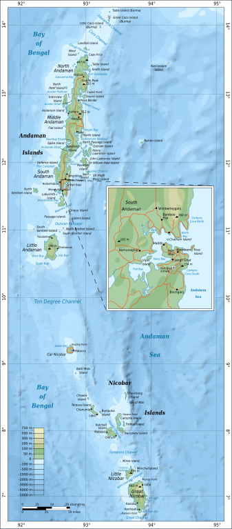
| sasa hivi | 16:24, 15 Septemba 2010 | | 906 × 2,060 (621 KB) | Mysid | {{Information |Description={{en|1=Map of the Nicobar and Andaman Islands.}} |Source={{own}}. Self-made in Inkscape. Based on the 1976 CIA Indian Ocean Atlas (File:Andaman nicobar 76.jpg); bathymetry and topography from SRTM30_PLUS. |Author=[[w:User:M |
Matumizi ya faili
Ukurasa huu umeunganishwa na faili hili:
Matumizi ya faili ulimwenguni
Wiki nyingine hutumia faili hizi:
- Matumizi kwa af.wikipedia.org
- Matumizi kwa ar.wikipedia.org
- Matumizi kwa ast.wikipedia.org
- Matumizi kwa az.wikipedia.org
- Matumizi kwa be.wikipedia.org
- Matumizi kwa br.wikipedia.org
- Matumizi kwa ca.wikipedia.org
- Matumizi kwa en.wikipedia.org
- Matumizi kwa eo.wikipedia.org
- Matumizi kwa es.wikipedia.org
- Matumizi kwa fi.wikipedia.org
- Matumizi kwa fi.wiktionary.org
- Matumizi kwa fr.wikipedia.org
- Matumizi kwa ga.wikipedia.org
- Matumizi kwa gom.wikipedia.org
- Matumizi kwa ha.wikipedia.org
- Matumizi kwa hi.wikipedia.org
- Matumizi kwa hi.wikibooks.org
- Matumizi kwa hy.wikipedia.org
- Matumizi kwa it.wikipedia.org
- Matumizi kwa ja.wikipedia.org
- Matumizi kwa mr.wikipedia.org
- Matumizi kwa oc.wikipedia.org
- Matumizi kwa pl.wikipedia.org
- Matumizi kwa pnb.wikipedia.org
- Matumizi kwa ru.wikipedia.org
- Matumizi kwa te.wikipedia.org
- Matumizi kwa tg.wikipedia.org
- Matumizi kwa uk.wikipedia.org
- Matumizi kwa ur.wikipedia.org
- Matumizi kwa www.wikidata.org
- Matumizi kwa zh.wikipedia.org