Faili:Adams bridge map.png
Adams_bridge_map.png (piseli 519 × 239, saizi ya faili: 25 KB, aina ya MIME: image/png)
| Faili hili linatoka Wikimedia Commons. Maelezo yapo kule kwenye ukurasa wake wa maelezo unaonekana hapo chini.
|
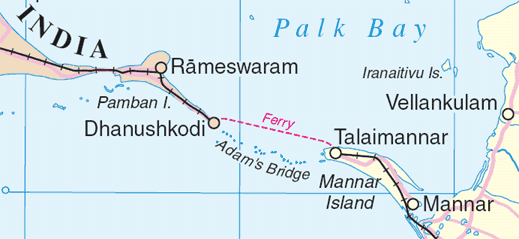
Map of en:Adam's Bridge, India/Sri Lanka
Extracted from www.un.org/Depts/Cartographic/map/profile/srilanka.pdf
| This image is a map derived from a United Nations map.
Unless stated otherwise, UN maps are to be considered in the public domain. This applies worldwide. UN maps are, in principle, open source material and you can use them in your work or for making your own map. UN requests however that you delete the UN name, logo and reference number upon any modification to the map. Content of your map will be your responsibility. You can state in your publication, if you wish, something like: based on UN map … (map name, map number, revision number and date). See: Geospatial Information Section. And: Geospatial, location data for a better world. |
 |
Historia ya faili
Bonyeza tarehe/saa kuona faili kama ilivyoonekana wakati huo.
| Tarehe/Saa | Picha ndogo | Vipimo | Mtumiaji | Maelezo | |
|---|---|---|---|---|---|
| sasa hivi | 01:55, 4 Agosti 2006 | | 519 × 239 (25 KB) | Gugganij | Map of Adam's Bridge, India/Sri Lanka Extracted from http://www.un.org/Depts/Cartographic/map/profile/srilanka.pdf {{UN map}} |
Matumizi ya faili
Ukurasa huu umeunganishwa na faili hili:
Matumizi ya faili ulimwenguni
Wiki nyingine hutumia faili hizi:
- Matumizi kwa ar.wikipedia.org
- Matumizi kwa az.wikipedia.org
- Matumizi kwa ba.wikipedia.org
- Matumizi kwa be.wikipedia.org
- Matumizi kwa bn.wikipedia.org
- Matumizi kwa cs.wikipedia.org
- Matumizi kwa de.wikipedia.org
- Matumizi kwa el.wikipedia.org
- Matumizi kwa en.wikipedia.org
- Matumizi kwa eo.wikipedia.org
- Matumizi kwa es.wikipedia.org
- Matumizi kwa et.wikipedia.org
- Matumizi kwa fi.wikipedia.org
- Matumizi kwa fr.wikipedia.org
- Matumizi kwa fy.wikipedia.org
- Matumizi kwa gl.wikipedia.org
- Matumizi kwa gu.wikipedia.org
- Matumizi kwa he.wikipedia.org
- Matumizi kwa hu.wikipedia.org
- Matumizi kwa id.wikipedia.org
- Matumizi kwa it.wikipedia.org
- Matumizi kwa ja.wikipedia.org
- Matumizi kwa kn.wikipedia.org
- Matumizi kwa ko.wikipedia.org
- Matumizi kwa la.wikipedia.org
- Matumizi kwa lt.wikipedia.org
- Matumizi kwa mai.wikipedia.org
- Matumizi kwa mk.wikipedia.org
- Matumizi kwa ml.wikipedia.org
- Matumizi kwa new.wikipedia.org
Tazama matumizi zaidi ya kimataifa ya faili hii.